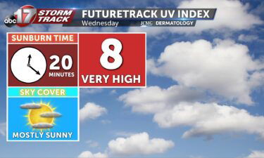
Wednesday’s UV index and pollen tracker
The UV index will be much higher on Wednesday with more sunshine as clouds exit. Pollen levels will be highest on Friday with warmer temperatures and gusty winds.
Continue Reading The UV index will be much higher on Wednesday with more sunshine as clouds exit. Pollen levels will be highest on Friday with warmer temperatures and gusty winds.
Continue Reading
Today: Scattered showers are expected to remain throughout much of Central Missouri throughout the afternoon and evening hours. The heaviest downpours are expected to remain in southwestern parts of Central Missouri exiting by 4 PM. Some areas to the south could see up to 0.75″ of additional rainfall, while most should see less than 0.5″.
Continue Reading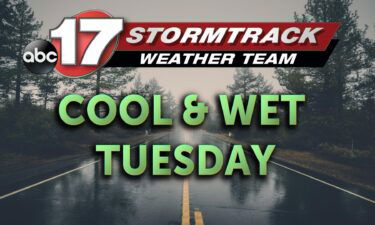
TODAY: This morning, showers and storms are ongoing along an upper level boundary draped across mid-Missouri. This boundary will slowly work south, while rain will move along the boundary in a general west to east fashion. This will bring the possibility for more than an inch of rain almost areawide. By noon, the heaviest rainfall
Continue Reading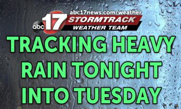
TONIGHT: Mostly cloudy with widespread rain and a few storms overnight. Lows in the mid-60s. 1-2″ rain likely by Tuesday afternoon. TOMORROW: Showers and storms likely. Rain could be heavy at times, especially in the morning. Highs near 70. EXTENDED: We’re tracking a complex of storms to the north this evening that will get enhanced
Continue Reading
The UV index will be quite low with storms in the area on Tuesday, along with pollen levels. Allergens this week will be more noticeable by Thursday and Friday.
Continue Reading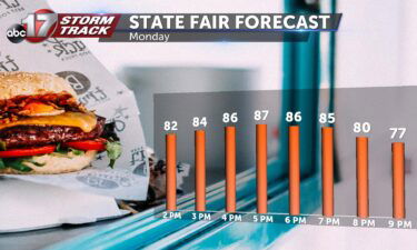
This Afternoon: Partly cloudy and cooler in the mid-80s. UV index up to 7 – sunburn possible in as little as 30 minutes. Tonight: Mostly cloudy and mild with light showers possible north of I-70 near sundown. Heavy rain arrives after midnight, becoming most widespread during the Tuesday morning commute. Extended: Subseasonal conditions have settled
Continue Reading
TODAY: Cool to start in the lower 60s. Partly cloudy skies subdue highs to the mid to low 80s. THIS EVENING: Mostly cloudy and mild with steadily falling temperatures overnight. EXTENDED: Subseasonal conditions have settled over the region today as a cold front moved through over the weekend. This frontal boundary has now stalled out
Continue Reading
TODAY: Partly to mostly cloudy with highs in the low 90s. Heat index in the upper 90s. TOMORROW: Cool to start the day with lows in the lower 60s. Northerly winds keep highs sub-seasonal in the mid to low 80s. EXTENDED: High pressure continues to hold strong to our southwest, leading to one more day
Continue Reading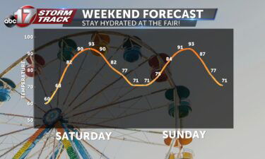
TODAY: Mostly sunny and muggy with highs in the mid-90s. Heat index from 98-100. TOMORROW: Partly cloudy and a tad cooler in the lower 90s. Feels-like in the upper 90s. EXTENDED: High pressure dominates the Southern Plains this weekend and will keep stable conditions in place over Mid-MO. A weak front will squeeze in from
Continue Reading
The rescue team was sent to Kentucky at the end of July to help with disastrous flooding.
Continue Reading
TONIGHT: Mostly clear to partly cloudy with lows in the mid-upper 60s. TOMORROW: Mostly sunny, hot, and breezy with highs in the lower to mid-90s. Heat index between 98-100. EXTENDED: . I’m tracking a small eastward advance in upper high pressure that will keep any rain out of the area tomorrow, and a warm front
Continue Reading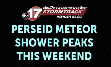
The Perseid meteor shower is expected to peak this weekend, but we may have a tough time seeing it due to a full moon brightening the sky. The Perseids peak every year from mid-July through late August. The peak will be tonight and Saturday night after dark through just before dawn. The shower is caused
Continue Reading
The UV index will be high on Saturday with plenty of sunshine. Sunburn time will be around 30 minutes. Pollen levels will be high over the weekend, but decrease next week with rain in the forecast.
Continue Reading
Today: Mostly sunny with highs in the mid-upper 80s. Tonight: Mostly clear skies with a mild start to the weekend in the low 70s. Extended: Summer heat returns this weekend as high pressure to our west moves back in our direction and winds pick up from the southwest. That will bring highs back to the
Continue Reading
TONIGHT: Increasing clouds, keeping temperatures a bit warmer overnight. Lows in the upper 60s. TOMORROW: Partly to mostly sunny with highs in the mid-upper 80s. EXTENDED: Tonight is a bit warmer as a weak front will bring a few more clouds overnight into Friday morning, keeping us in the upper 60s. Tomorrow is similar with
Continue Reading
Missouri Task Force 1 is on the way back to Columbia after they received their demobilization orders Thursday morning.
Continue Reading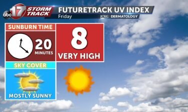
The UV index will continue to be high on Friday with a sunburn time between 20-30 minutes. Pollen levels will be highest on Sunday as temperatures rise.
Continue ReadingThis Afternoon: Another gorgeous day with seasonal highs in the upper 80s. Dewpoints will hover in the low 60s, lending to less humid conditions. Tonight: Mild and dry as winds begin to shift out of the south. Lows fall to the upper 60s. Extended: This wind shift out of the south comes as a weak
Continue Reading
DROUGHT MONITOR: The drought monitor is a product collaboratively produced by various government agencies and other organizations, to keep tabs on how dry (or not) communities are around the country. The product is updated every Thursday morning based on data collected through Tuesday morning of the same week. This means the drought monitor is updated
Continue Reading
TODAY: Thursday is starting cool, with temperatures in the low 60s to start the day. Dewpoints will remain in the low 60s, possibly even in the high 50s through the day today. This will make Thursday another pleasant feeling day. Mostly sunny skies carry us into the upper 80s to nearly 90. TONIGHT: Temperatures won’t
Continue Reading