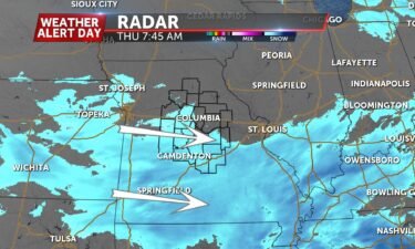
WEATHER ALERT DAY: Extreme cold settles in on Mid-Missouri
A Weather Alert Day has been issued for Thursday, with frigid temperatures and snow expected.
Continue Reading A Weather Alert Day has been issued for Thursday, with frigid temperatures and snow expected.
Continue Reading
FRIDAY: We’re starting off cold but we’ll start to turn the tide of this latest Arctic outbreak. Temperatures will only make it into the middle 20’s this afternoon but winds will start to shift out of the south. Partly cloudy skies will at least help spirits heading into the weekend. TONIGHT: Those winds will pick
Continue Reading
TONIGHT: Cold air sticks around tonight. Temperatures will drop into the single digits overnight, with a slight breeze making it feel even colder. At worst, it may feel like subzero temperatures early Friday. FRIDAY: After a cold start, temperatures will make their greatest jump in two days, with highs expected in the mid 20’s. Southerly
Continue Reading
THURSDAY: Light snow will move through this morning, primarily south of I-70. As cold as it is, slick spots will develop easily when it’s falling. Up to an inch will be possible for areas around the lake and I-44, with lesser amounts further north. Highs today will be stuck in the teens. TONIGHT: Temperatures will
Continue Reading
TONIGHT: Snow moves in tonight, around 9-10 p.m. for western most counties along and south of I-70. This is where we expect the dividing line to be for most. Folks north of 70, especially east of Hwy 63 will have the lowest chance at seeing snowfall, let alone accumulations. Temperatures turn bitterly cold late tonight.
Continue Reading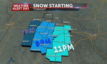
WEDNESDAY: Highs in the low 20s. Gusty winds up to 30 mph will keep wind chills in the teens and single digits. TONIGHT: Snow will move in this evening and favor areas along and south of I-70. Lows tonight will fall into the low teens. Wind chills plummet to near zero. For more details on the snow
Continue Reading
WEDNESDAY: Colder air is returning this morning. Highs this afternoon will be stuck in the 20’s for many of us with a westerly breeze to contend with. Gusts could reach 30 mph this morning. TONIGHT: Snow will move in this evening and favor areas along and south of I-70. Lows tonight will fall even further,
Continue Reading
TONIGHT: Temperatures tonight drop down into the low 20’s, if not high teen’s, by early Wednesday morning behind a dry cold front. WEDNESDAY: North flow really dominates the forecast on Wednesday. Expect temperatures to struggle Wednesday. Highs will hover around high 20’s and low 30’s with an ongoing north breeze throughout the day. Wednesday night,
Continue ReadingToday: A nice change in pace for Central Missouri weather as warm southerly flowing winds and sunshine help warm us into the mid-’40s. Winds remain gusty sustained at 15-20 mph. Tonight: A cold front slides in from the northwest late tonight helping aid a cooldown with lows back into the lower ’20s. Winds slowly shift
Continue Reading
TUESDAY: We’re off to a warmer start and some more added sunshine will help matters out this afternoon. Temperatures will top out in the 40’s later today but that breeze will pick up. Gusts out of the south up to 30 mph will be something to contend with. TONIGHT: Temperatures will stay fairly mild, in
Continue Reading
TONIGHT: Mostly clear skies this evening will persist through the night into Tuesday morning. Temperatures return to sub-freezing territory, meaning what melted today will re-freeze. TUESDAY: Temperatures climb back into the mid 40’s (a few degrees above average) on Tuesday, further thawing any lingering snow and ice. Sunshine dominates early, with added clouds returning in
Continue ReadingToday: Warm, southerly flowing winds and sunny sky conditions allow for temperatures to rebound into the upper ’30s. Tonight: Temperatures cool down once again but not nearly as cold as what we saw this past weekend. The overnight lows bottom out into the mid-’20s. Extended: Tuesday looks to be the warmest day of the week
Continue Reading
MONDAY After another frigid start this morning, we’re starting to move in the right direction this afternoon. Plenty of sunshine and winds turning more southerly will bump temperatures into the upper 30’s today. TONIGHT We’ll be left with those mostly clear skies overnight but it won’t be nearly as cold as it’s been the past
Continue Reading
Tonight: Winds continue to calm down out of the northwest at4-8 mph. The overnight low drops to the single digits at 7 degrees for Columbia with clear skies. Tomorrow: Winds slowly change back out of the southwest by the afternoon hours on Monday with highs into the upper ’30s and sunny conditions. Extended: Tuesday continues
Continue Reading
Sunday Morning Update: Icy and slick roads remain a concern this morning with temperatures in the teens and wind chills plummeting below 0 degrees. Expect poor travel conditions for the rest of the weekend and try to stay home as much as possible. Current road conditions for Mid-MO can be found here. Brutal Cold Temperatures
Continue Reading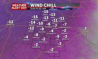
SUNDAY: A Weather Alert Day is in effect to end the weekend for dangerous cold conditions today. Snow flurries will be possible before sunrise with low temperatures falling into the single digits. Wind chills will plummet to the negative teens so stay indoors as much as possible today. Frostbite can set in in as little as
Continue Reading
TONIGHT: Snow showers will be off and on at times until midnight as temperatures continue to plummet. They’ll bottom out in the upper single-digits, but with the wind keeping up, it will feel like 15 to 20 degrees below zero. Light accumulations will be possible but roads will continue to deteriorate throughout the evening and
Continue Reading
SATURDAY: A Weather Alert Day is in effect for New Year’s Day for impacts from a winter storm. Showers are moving through southeastern Missouri, with a transition to a wintry mix along and north of I-70. Far northern counties in our area are also likely to see snow near sunrise. As temperatures continue to drop throughout
Continue Reading
TONIGHT: A big warmup has temperatures pushing upper 50’s and low 60’s this afternoon. A big influx of warmth and moisture will end us warm with a chance for showers late tonight. These are part of a strong system that will pull in cold air early Saturday that will turn showers into a wintry mix
Continue Reading