Skip to Content

Weather

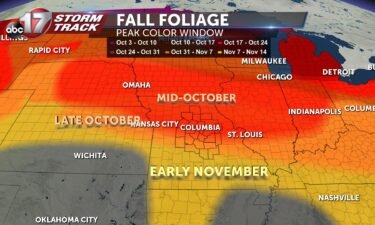
Tracking critical fire weather conditions

TODAY: The word of Thursday’s forecast is GUSTY. Winds will gradually turn from westerly to northwesterly into the afternoon, while sustained near 15-20 mph. Gusts will range from 25-35 mph this afternoon. Partner this with a relative humidity below 20% and we have a recipe for dangerous fire behavior. The National Weather Service offices in

Continue Reading

Fall foliage update

Mid-Missouri is nearing the halfway mark of October as leaves are continuing to change colors. The current foliage tracker has remained the same as the previous weeks for the peak color changing time period for Mid-Missouri. Areas along and north of I-70 are expected to see peak vibrant colors beginning October 17 lasting through October

Continue Reading

Tracking chances for measurable rain

TODAY: Monday continues our warming trend, with south wind and plenty of sunshine. Expect today to start clear, with partly cloudy skies by this afternoon. With the aforementioned southwest breeze in the 5-10 mph range, temperatures will climb to near 80 for highs. TONIGHT: Low level winds are pulling in warm air, but also more

Continue Reading

Tracking an early week warmup

Today: Chilly in the morning with lows in the upper 30s. Temperatures recover nicely with southerly winds picking up today, and highs make it all the way to the mid-70s. Wind gusts could reach up to 20 mph. Tomorrow: Southerly flow lends to a slight warmup, with highs climbing to near 80 degrees Monday afternoon.

Continue Reading
Skip to content