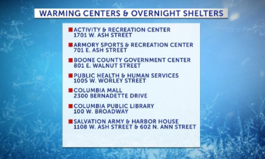
Warming shelters open as temperatures continue to drop
The Wabash bus station is the latest warming shelter to open its doors in Columbia as temperatures overnight continue to be dangerous.
Continue Reading The Wabash bus station is the latest warming shelter to open its doors in Columbia as temperatures overnight continue to be dangerous.
Continue Reading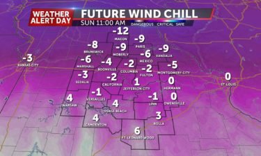
TODAY: Temperatures will warm into the lower 20s, but a wind chill factor will make it feel as if the temperature were near zero. A few clouds are possible, otherwise, we will remain sunny. TONIGHT: Frigid conditions continue with sustained winds overnight. Lows will be near single digits. EXTENDED: Even colder air is set to build in
Continue Reading
TONIGHT: It will be very cold overnight. Temperatures fall into the low teens. Wind chills will be between 0º and -5º by sunrise. SUNDAY: Cold and breezy conditions all day. Wind chills will remain in the single digits all day as temperatures will struggle to get into the upper teens and low 20s. A few
Continue Reading
TODAY: Cloud coverage decreases throughout the day, but winds increase. We will see a steady decline in temperatures until we reach the 20s by later in the day. Wind chills will make it feel as if the temperature were in the teens. TONIGHT: Overnight, cooler temperatures with strong winds will prevail. Lows in the single
Continue Reading
A line of severe winter storms that moved across mid-Missouri Friday downed trees and caused power outages. A tree in a yard of the 1300 block of Robert Ray Drive uprooted and fell on a resident’s home. Another tree in the neighborhood uprooted and split, causing a branch to fall into the street. Authorities were
Continue Reading
Boone Electric Cooperative is reporting more than 700 members without power in five separate outages.
Continue Reading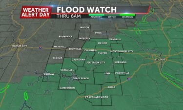
Some of us have been upgraded from a Winter Storm Watch to a Winter Weather Advisory. A Winter Storm Watch is still in effect through late Friday night for the eastern half of Mid-Missouri as winter weather is expected to impact roads Friday morning.
Continue Reading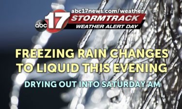
TONIGHT: Freezing rain changes to rain for the rest of the night. An additional 1″ to 1.5″ will be possible overnight. Temperatures remain steady in the mid-30s. SATURDAY: Clouds gradually decrease, but it’s breezy with gusts up to 35 mph. Temperatures fall into the 20s during the day. Wind chills in the low teens. EXTENDED:
Continue Reading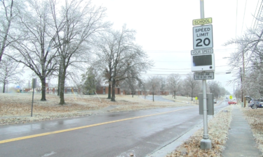
Boone County Road and Bridge said road conditions should improve by Saturday.
Continue Reading
The Missouri Department of Transportation said road conditions are worsening, contributing to slide-offs.
Continue Reading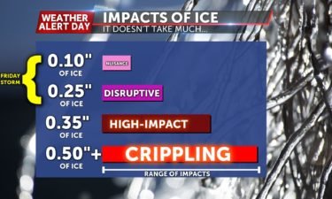
TODAY: Snow changes to freezing rain by late morning, lasting into the afternoon. A tenth to a quarter inch of ice accumulation is possible. Freezing rain changes to rain by mid-evening as temperatures rise above freezing. TONIGHT: Rain continues into early tomorrow morning. Lows in the mid 30s. EXTENDED: Windy conditions will persist after the
Continue ReadingCrews were busy pretreating roads Thursday afternoon ahead of Friday’s winter storm and the University of Missouri said its offices would be closed.
Continue Reading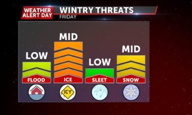
TONIGHT: Mostly cloudy, snow moves in from the southwest after midnight. Lows in the mid-upper 20s. FRIDAY: Snow changes to freezing rain by late morning, lasting into the afternoon. A tenth to a quarter inch of ice accumulation is possible. Freezing rain changes to rain by mid-evening as temperatures rise above freezing. Lows in the
Continue Reading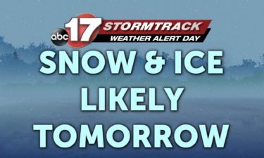
THURSDAY: Cold start to the day will be the theme throughout as temperatures only warm up to the low 30s for afternoon highs. TONIGHT: Snow pushes in after midnight, and will likely impact the roadways shortly after beginning to fall. Lows will fall into the middle 20s. EXTENDED: Eventually the snow will start to mix
Continue Reading
Freezing rain can be one of the most disruptive types of weather we can experience. It can cause havoc on roads and wipe out power over a widespread area. We’re going to show you how freezing rain forms and the impacts we can expect for Friday’s system. How we typically illustrate freezing rain This is
Continue Reading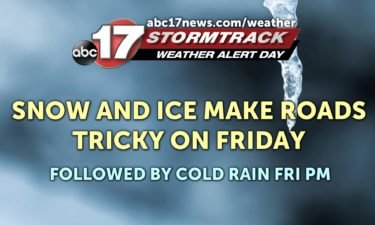
TONIGHT: Clouds gradually decrease with lows falling into the upper teens. THURSDAY: It’s much colder with highs only reaching the lower 30s. We’ll start off clear, but clouds build back in late in the day. EXTENDED: A Weather Alert Day is in place for Friday as precipitation slides in from the southwest after midnight Thursday
Continue Reading
THIS EVENING: A cold front is steadily dropping south this afternoon. Expect drizzle and falling temperatures alongside gusty north winds. You’ll need the jacket headed out this evening. TONIGHT: Under mostly clear skies temperatures fall all the way into the upper 10s, bundle up– it will be very cold into the morning. EXTENDED: With that
Continue Reading
Since the official start of winter on Dec. 21, things have been anything but winter-like in mid-Missouri. We tied our second-warmest Christmas. We also took second place for the warmest start to the season (between Dec. 21 and Jan. 13) based on average a 50.8-degree average high temperature. The only other year with a warmer
Continue Reading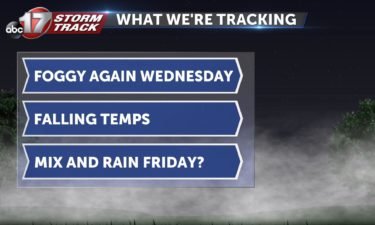
TONIGHT: Increasing clouds, patchy fog developing late. A few showers possible. Lows in the low to mid-40s. WEDNESDAY: Foggy to start with a few sprinkles early, mainly north of I-70. Partly cloudy with temperatures falling from the 50s to the 30s during the day. EXTENDED: Following a weak cold front, temperatures Thursday will be much
Continue Reading
TUESDAY: We’ll wake up to some patchy fog, but with temperatures above freezing, slick spots are not an issue like yesterday. We’ll manage some sun this afternoon as partly cloudy skies move in as highs top out in the upper 40’s to low 50’s again. TONIGHT: A cold front will move toward the region overnight,
Continue Reading