
Tracking more storm chances this morning
Another round of storms is on its way this morning.
Continue Reading Another round of storms is on its way this morning.
Continue Reading
TONIGHT: Partly to mostly cloudy with storms moving in late. Rain could be heavy at times after midnight with gusty winds. Lows in the low 70s. TOMORROW: Storms early, tapering off by late morning. Highs near 90 with a heat index in the mid-upper 90s. EXTENDED: The boundary responsible for thunderstorms the last two days
Continue Reading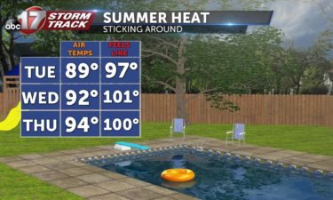
TODAY: Showers and storms have begun to push into the viewing area, and we could see some flashes of lightning and moderate rainfall as they continue to move through mid-Missouri. We are still expecting some dry time for the day, as well as some humid conditions. Actual temperatures will be in the upper 80s for the
Continue Reading
Monday Morning Update:It’s starting to look like we may have avoided the worst of the flooding threat so far. We’ll continue to monitor trends on radar, but the area of concern has shifted more into Illinois this morning. There’s still a chance we pick up some afternoon showers & storms, east of HWY 63. A
Continue Reading
TUESDAY: Showers and storms will greet some of us out the door this morning. Most of the activity should stay east of HWY 63 and north of I-70. The rest of us will be quiet with a mix of sun and clouds as temperatures make it into the upper 80’s this afternoon. TONIGHT: Some more
Continue Reading
TONIGHT: Scattered storms early, with heavy rain moving in overnight for areas along and north of I-70 through morning. Rain amounts will be between 2-4″ with the highest amounts across northeast Missouri. Lows in the low 70s. TOMORROW: Rain and storms early, becoming hot and humid with highs in the upper 80s and heat indices
Continue Reading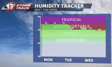
For more Weather Alert Day information, check out our blog. https://abc17news.com/news/2020/06/29/weather-alert-day-flooding-rainfall-summer-heat-to-affect-mid-missouri-this-week/ TODAY: Temperatures will be rising into the 90s for the afternoon with humidity pushing us into a heat index value in the mid 90s. There also are some chances for portions of the viewing area to see storms as we push into the afternoon and
Continue Reading
Several counties in Missouri including Boone, Moniteau, Cole, Callaway, Osage, Gasconade, Montgomery, Audrain and Monroe are in a flash flood watch.
Continue Reading
TONIGHT: Temperatures will remain warm overnight dropping into the low 70s. It will be muggy out the door in the morning. MONDAY: We’re going to stay dry for most of the day Monday. Temperatures warm right back up to near 90. Clouds will increase through the afternoon as storm system approaches from Oklahoma. Thunderstorms are possible
Continue Reading
SUNDAY: A warm front is lifting back through the area this morning. That will bring the return of the heat back to Mid-Missouri this afternoon with highs reaching the low 90’s. When factoring in the humidity, things will feel like the upper 90’s this afternoon so be sure to drink plenty of water. TONIGHT: A
Continue Reading
TONIGHT: A few storms are possible early. Temperatures remain mild in the 70s. SUNDAY: The heat and sunshine make a return tomorrow. Expect temperatures in the low 90s with heat index values between 95-100º through the afternoon. Have the water and sunscreen ready if you’re going to be spending time outdoors! EXTENDED: We look to hold
Continue Reading
SATURDAY: Storms are moving through this morning. The severe threat seems fairly tame with these having arrived a little too late overnight. We’ll be tracking some storms not only this morning but redeveloping later this afternoon and evening. There’s a slim chance one or two of these is on the strong side with some hail
Continue Reading
TONIGHT: Increasing clouds and humid with lows in the low 70s. A few storms possible late, likely before sunrise. Some could bring heavy rain and frequent lightning. TOMORROW: Showers and storms in the morning followed by partly cloudy skies. Highs in the low to mid-80s. Scattered storms possible by afternoon, with potentially isolated damaging winds
Continue Reading
The next couple of days are going to feature air that feels a bit more muggy! It’s a classic sign that we’re turning the corner out of cold, wintry weather. However, many times we confuse humidity with a “humid” atmosphere. (I know, that makes no sense– Blame the guy who came up with the calculation
Continue Reading
TODAY: Hot and humid with plenty of sunshine. Highs get into the low 90s with a heat index between 95-96. TONIGHT: Storms should stay north until sunrise. They will increase through Saturday morning. It will remain warm and muggy with temperatures near 71. EXTENDED: Saturday will feature on and off thunderstorms– this will allow us
Continue Reading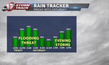
TODAY: Hot and humid with plenty of sunshine. Highs get into the low 90s with a heat index between 95-96. TONIGHT: A cold front will remain just to our north in Iowa and northern parts of Illinois. This cold front will move south across Mid-Missouri as we transition into Saturday morning. Latest model runs suggest
Continue Reading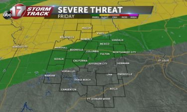
After a pleasant start to the week, the return of summer-like weather is looming with heat, humidity, and storms all in the forecast for the weekend and beyond. Moisture is beginning to creep back into the region as high pressure builds to our south in the upper levels of the atmosphere. This will allow southwesterly
Continue Reading
TONIGHT: Mostly clear and muggy with lows in the low 70s. TOMORROW: Hot and humid with plenty of sunshine. Highs get into the low 90s with a heat index between 95-96. EXTENDED: A cold front to our north Friday night will trigger a line of strong to severe thunderstorms across Iowa and northern Illinois that
Continue Reading
This week is Lightning Safety Week. It’s we head into the most active months for daily lightning across the United States which falls between late June and August. One of the things that makes lightning so dangerous is because of the misinformation and myths which surround the phenomenon. One popular myth is that if the
Continue Reading
THIS AFTERNOON: Warm and humid conditions have built into the area. Stay hydrated and pack the sunscreen if y ou have plans to be outside. Temperatures will hold near 90. A spot storm is possible south of HWY 54. TONIGHT: Staying quiet & muggy overnight with lows only falling to near 70. EXTENDED: Friday is looking to stay
Continue Reading