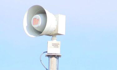
QUESTION OF THE DAY: Did you hear the warning sirens on Tuesday?
Missouri held a statewide tornado drill Tuesday with local governments, businesses and organizations participating.
Continue Reading Missouri held a statewide tornado drill Tuesday with local governments, businesses and organizations participating.
Continue Reading
Most people have all heard the familiar whining of a tornado siren. Now, this whine is meant to be heard outdoors, not indoors, and a lot of times it will not siren the entire time of a warning. To stay safe you’re going to want to make sure you stay in tune with your local
Continue Reading
TONIGHT: Rain likely overnight with gusty winds. Lows in the upper 30s. TOMORROW: Showers exiting by mid-morning. Breezy with highs in the mid-40s. EXTENDED: Showers finally start to cut through dry air by this evening, with light to moderate rain continuing overnight. I’m expecting showers to exit to the east by mid-late morning tomorrow, leaving
Continue Reading
TODAY: Tuesday is noticeably cooler than Monday, with a north breeze. Temperatures start in the 30s, and climb into the low 50s. This puts us near our average high temperature for this time of the year. Skies are partly cloudy to start the day, but clouds will increase in coverage through the day. By the
Continue Reading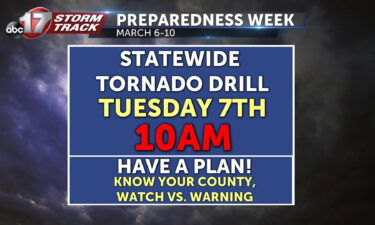
It’s Monday March 6, which means it’s the first day of Severe Weather Preparedness Week. Each day, we’re going to cover a variety of topics to help keep you ready in in the know when inclement weather comes into your area. The best way to receive information on inclement weather in your area is to
Continue Reading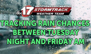
TONIGHT: Increasing clouds, breezy, and cooler with lows falling into the mid-upper 30s. TOMORROW: Mostly cloudy with evening rain showers moving in around sunset or just before. Highs in the lower 50s. EXTENDED: A cold front sliding south through the area tonight will bring clouds and cooler temperatures overnight into Tuesday. Tuesday starts off dry
Continue Reading
Today: Afternoon highs peak at or just below 70 degrees today with winds out of the northwest at 10-15 mph with gusts up to 25 mph. Skies look to remain mostly sunny. Tonight: Overnight lows cool to the mid-30s with winds remaining out of the north at 10-15 mph. Cloud cover increases to partly cloudy.
Continue Reading
TODAY: Our southwest breeze continues this morning, until around midday, when a cold front is expected to slide through the region. Temperatures will warm to near 70, with most in the upper 60s, and a few southeast of Jefferson City having a chance at 70 or more. TONIGHT: Temperatures will fall into the 50s through
Continue Reading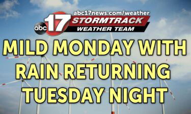
TONIGHT: Mostly clear to partly cloudy with lows in the low to mid-50s. Breezy with gusts between 20-25 mph. TOMORROW: Mostly sunny and breezy with highs in the upper 60s to around 70. Some areas may cool down from north to south as a cold front works through during the late afternoon. EXTENDED: We’re in
Continue Reading
TODAY: Patchy fog in the early morning clears out quickly as southerly winds pick up. These gusts could reach up to 30-35 mph this afternoon but fuel a dramatic warmup aided by more sunshine. Highs reach the mid to upper 60s. TOMORROW: One last day above-average as we climb near 70 degrees early Monday afternoon.
Continue Reading
TONIGHT: Skies clearing up, and calm winds spread through the area. Patches of fog could be observed later in the night, especially around rivers. TOMORROW: Clear skies are expected with winds picking up, bringing us chances for 30-35 mph gusts. With these winds, it allows us to warm up into the upper 60s for our
Continue Reading
TODAY: Fog is possible early morning around river valleys and areas that received healthy precipitation on Friday. A few sprinkles from a weak front are possible just before noon but most will just see clouds. These are expected to break away by the afternoon with highs reaching the upper 50s. TOMORROW: Winds kick up early
Continue Reading
Tonight: Overnight lows cool near or just below freezing tonight as winds remain out of the northwest at 5-10 mph. Skies look to clear throughout the overnight hours becoming mostly clear. Tomorrow: Skies look to become partly cloudy as winds switch out of the west starting the upcoming warming trend with highs reaching into the
Continue Reading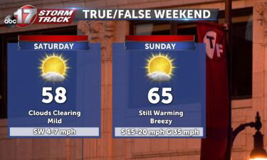
THIS AFTERNOON: Rain totals southeast of Jefferson City are approaching between 1-3″ as rain pulls out early in the afternoon. Those to the northwest are drier but expect gusty winds areawide through sundown up to 25 mph. TONIGHT: Skies mostly clear out overnight but we’ll still see clouds most of Saturday. Lows dive to the
Continue Reading
TODAY: Rain is moving through the region this morning, with temperatures cold, but not cold enough for snow; at least not to any meaningful extent. As rain continues to push northeast, and we see showers move through our coldest communities this morning, we may see a few snowflakes mix in with the rain. The best
Continue Reading
TONIGHT: Showers likely overnight into Friday morning. Gusty winds up to 30 mph. Lows in the mid-30s. TOMORROW: Rain likely with wet snow showers mixed in for areas north of Highway 24. Snow amounts will end up less than an inch in this area, and likely won’t accumulate on the roads with road temperatures above
Continue Reading
Today: Afternoon highs rise to the lower 50s with mostly cloudy skies eventually leading to widespread showers after 4 PM. Heavy downpours can be expected at times with winds out of the northwest at 5-10 mph with gust up to 25 mph. Tonight: Overnight lows cool to the mid-30s with widespread showers covering the region.
Continue Reading
UPDATE: The blog below has been updated as of 8:45 am Thursday. This update reflects a shift in track to the east from what was broadcast Wednesday. BLOG: After a spring-like week, the Stormtrack Weather Team is tracking a strong low pressure system that will move in from the southern Plains on Thursday and bring
Continue Reading
TODAY: Thursday is a nearly average day temperature-wise. Expect temperatures to approach upper 40s and low 50s from north to south, with an exception near the Lake of the Ozarks. This is where we’ve been exceptionally warm the past few days, but approaching showers and storms after the lunch hour will keep temperatures in the
Continue Reading