
Wednesday’s UV index and pollen tracker
The UV index will be very high by midday after morning clouds. Allergen levels remain high through the weekend. Ragweed, Chenopods, and Nettle are the primary allergens.
Continue Reading The UV index will be very high by midday after morning clouds. Allergen levels remain high through the weekend. Ragweed, Chenopods, and Nettle are the primary allergens.
Continue Reading
TONIGHT: Cool weather sticks around, at least for the near term. Skies will continue as high pressure nudges into the region overnight. This brings clear, calm, and cool conditions into the early morning hours Wednesday. TOMORROW: We’ll start in the 50s across much of mid-Missouri, with some river valley fog, and likely near other bodies
Continue Reading
After the hottest July recorded globally, Mid-MO cooled down early this month to near or below-average temperatures. But the summer heat is not done with us just yet as long-term forecasts trend back to warmer than normal. The next several weeks could see persistent dryness as well, adding on to drought from months past. Temperatures
Continue Reading
This Afternoon: Skies begin partly cloudy becoming mostly sunny by late this afternoon. Highs top out into the mid-70s thanks to winds at 8-12 MPH from the northwest with gusts up to 18 mph possible. Tonight: Lows cool to the upper 50s with mostly clear skies and patchy fog around the region. Winds remain out
Continue Reading
Today: Afternoon highs top out into the mid-70s thanks to winds at 8-12 MPH from the northwest with gusts up to 18 MPH possible. Skies begin partly cloudy becoming mostly sunny by later afternoon hours. Tonight: Overnight hours cool to the upper 50s with mostly clear skies and patchy fog around the region. Winds remain
Continue Reading
The UV index will be very high by midday after morning clouds. Allergen levels remain high through the weekend. Ragweed, Chenopods, and nettle are the primary allergens.
Continue Reading
TONIGHT: We’ll stay somewhat breezy this evening, as we continue to deal with the parent system from yesterday’s storms. Clouds fill in overnight, and temperatures remain in the low 60s. For these reasons, fog is unlikely overnight. TOMORROW: Clouds will slowly clear Tuesday morning. We may start mostly to partly cloudy depending on well these
Continue Reading
Rainfall early this month has already been record-setting as Columbia has recorded its third wettest August ever so far. The majority of the area is above-average on rain, with parts of Mid-Missouri receiving over three times their normal rainfall in recent weeks. Though this hasn’t been enough to break our long-term drought, and the rest
Continue Reading
Today: Skies remain partly cloudy as highs warm into the mid-70s. Winds will be noticeable out of the west at 12-18 MPH and gusts up to 32 mph are possible. Tonight: Overnight lows cool to the upper 50s as winds switch out of the north at 10-15 MPH. Skies remain partly cloudy. Extended: The second
Continue Reading
Today: Afternoon highs warm into the mid-70s as winds remain stronger out of the west sustained at 12-18 MPH with gusts up to 32 MPH possible. Skies remain partly cloudy with lingering showers south of I-70 clearing to the southeast as the day continues. Tonight: Overnight lows cool to the upper 50s as winds switch
Continue Reading
TONIGHT: It’s a Weather Alert Day for Mid-MO as another round of strong to severe storms is set to roll through in the evening and overnight hours. Trends have shown that the majority of this activity is set to appear over our southern counties, but we could see those threats sneak north if the correct
Continue Reading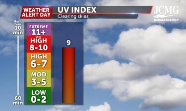
With skies clearing throughout the day tomorrow, Mid-MO will be tracking a UV index of 9. Without the protection of sunscreen that’s SPF 50 or higher, it only takes 15-25 minutes to receive a sunburn. With rain chances exiting tomorrow, Mid-MO will be seeing pollen levels staying at a medium for the majority of the
Continue Reading
TODAY: An ABC 17 Stormtrack Weather Alert Day is in effect Sunday for several rounds of storms possible. Rain will first move in early this morning, with a low chance for severe storms for the first part of the day. Conditions briefly dry up late this afternoon and evening, allowing the atmosphere to destabilize ahead
Continue Reading
SETUP: An upper level disturbance digs into the Upper Plains on Sunday, with its associated low pressure and fronts sweeping through the Midwest today. If a warm front can make it into Mid-Missouri, our severe chances will increase heavy-handedly. South of the warm front will be an environment rich in storm energy and shear. These
Continue Reading
TONIGHT: I’m tracking mostly dry conditions with the exception of the small chance of isolated rain showers. Temperatures will be dropping into the low 70s. TOMORROW: I’m tracking strong to severe storms throughout the majority of the day, which is why the Stormtrack Weather team has issued a Weather Alert Day from 4 AM until
Continue Reading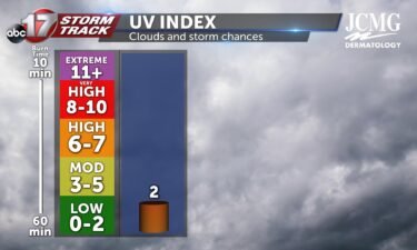
Tomorrow I’m tracking a UV index of 2 because of rain/storm chances throughout the whole day. This of course comes with plenty of cloud cover, not allowing nearly as many sun rays to reach the ground. Pollen levels will be staying at a medium level throughout next week with the help of rainfall tomorrow.
Continue Reading
MEXICO, Mo. (KMIZ)Around 3:30 am Saturday morning, the Mexico Public Safety Department found at least 25 locations in the area where tree limbs, utility lines are debris were blocking the roads. There are no reports of injuries from the storm. A press release from the department says that the department used equipment to remove parts
Continue Reading
TODAY: Scattered showers and storms are possible through the early morning, but hot conditions are still expected to follow. Highs climb to the upper 80s as rain shifts south this afternoon. TOMORROW: Storms return much of Sunday, possibly stronger to severe at times. Timing is still highly variable, but the first round of stronger storms
Continue Reading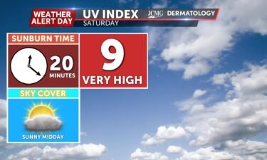
The UV index will be high by midday after morning showers and storms. Allergen levels remain moderate through the weekend. Grass, plantain, and nettle are the primary allergens.
Continue Reading
SETUP: Heat is building Friday afternoon as excess moisture flows into the region. This combination is destabilizing the atmosphere as a cold front approaches from the northwest, which could lead to strong storm development this evening. Enough energy and shear is present in the atmosphere to support organized strong to severe storms across the region
Continue Reading