Weather

Tracking more nuisance showers this morning
FRIDAY: Showers are still sticking around this morning but will try to shift south throughout the day. These scattered showers will stick around for the first part of the day, but into the afternoon will start that transition. Another day of rain chances and cloud cover will keep temperatures near 80. TONIGHT: Areas near I-44
Continue Reading
Heavy rain leaves behind some flooding in Cole County
Cole County Public Works Director, Larry Benz said the county saw five inches of rain Thursday night leaving behind flooding in parts of Brazito.
Continue Reading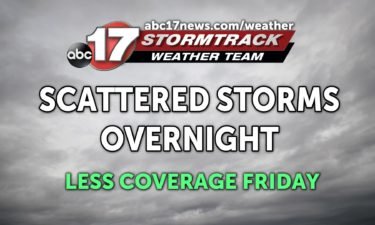
Tracking scattered storms tonight and Friday, continued cool pattern
TONIGHT: Mostly cloudy with scattered showers and a few rumbles of thunder. Mostly cloudy with lows in the upper 60s to around 70. TOMORROW: Mostly cloudy with a chance for showers and storms, especially south of Highway 50. Highs in the upper 70s to around 80. EXTENDED: Low pressure moves east Friday into Saturday, taking
Continue Reading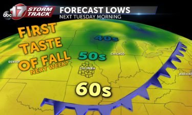
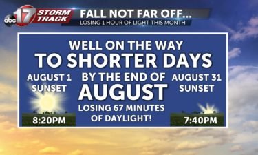
Taste of fall looks likely next week
We’ve gotten a break from the 90s this week but the humid, muggy weather has held on strong. That’s set to change as a strong cold front is set to burst south through mid-Missouri Sunday night. Much drier air will help us cool off into the 70s for highs with lows into the mid-to-upper 50s–
Continue Reading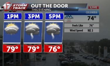
More rain Thursday, no heat in sight
THIS AFTERNOON: Continuing to track the potential of thunderstorm development along I-70 through the afternoon. Storms should become a little more widespread by the evening commute. Temperatures will remain in the upper 70s. TONIGHT: Scattered showers and a few rumbles of thunder will linger into the overnight hours. Lows will dip into the upper 60’s. EXTENDED: Things
Continue Reading
Tracking another soggy start
THURSDAY: Scattered showers and thunderstorms look to continue throughout the day. Another inch or two is expected with this round, which could be enough to cause some localized flooding. The rain and cloud cover will keep things cool again this afternoon, with highs in the upper 70’s and low 80’s. Want to peek at the
Continue Reading
Tracking drenching rain with scattered storms the next few days
TONIGHT: Cloudy and humid with ongoing scattered showers and thunderstorms. Some storms may bring heavy rain. Lows in the low 70s. TOMORROW: Mostly cloudy with scattered showers and storms. Additional rainfall between 1-2″. Highs in the upper 70s to low 80s. EXTENDED: Low level moisture continues to stream into the area tomorrow night, but the
Continue Reading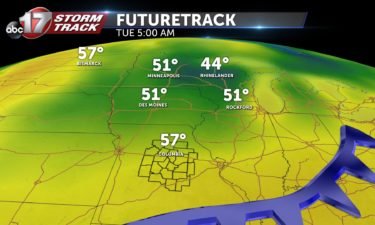
Stormier weather expected the next few days
THIS AFTERNOON: Storms have remained fairly scattered so far this morning– we’re expecting more coverage to develop as we progress through this evening. Thunder, lightning, and heavy downpours are the main threats. TONIGHT: Showers and storms still be coming and going throughout the night. Lows will fall to near 70. EXTENDED: More showers and storms will be
Continue Reading
Tracking showers and storms moving back in
WEDNESDAY: Our morning is looking dry initially, but showers and storms will return around midday. That rain will be off and on throughout the day, which will keep highs in the low to mid 80’s. TONIGHT: Showers and storms still be coming and going throughout the night. Lows will fall to near 70. EXTENDED:
Continue Reading
Tracking rounds of showers and storms, heavy rain possible
TONIGHT: Partly cloudy and mild with lows in the upper 60s. TOMORROW: Increasing clouds, chance of showers and thunderstorms increases through the day. Highs in the low to mid-80s. EXTENDED: After a gorgeous Tuesday, the chance for rain returns as a front slides back north across the southern third of the state on Wednesday. Temperatures
Continue Reading
Tracking a beautiful Tuesday
TODAY: A dry day looks to be in store for most of us. A stray shower or two is possible close to the I-44 corridor, down around the Lake of the Ozarks. Most of us will be on the drier side of this boundary, so highs in the mid to upper 80’s will feel a bit
Continue Reading
Tracking some pleasant weather by July standards
TUESDAY: A dry day looks to be in store for most of us. A stray shower or two is possible close to the I-44 corridor, down around the Lake of the Ozarks. Most of us will be on the drier side of this boundary, so highs in the mid to upper 80’s will feel a
Continue Reading
Tracking lower humidity Tuesday, heavy rainfall possible this week
TONIGHT: Scattered showers and storms early, becoming mostly cloudy. Lows in the low to mid-60s. TOMORROW: Partly to mostly sunny and less humid. Highs in the mid-80s. EXTENDED: We’re in for an unsettled week with an upper level trough or dip in the jet stream moving over us, along with several waves of energy sliding
Continue Reading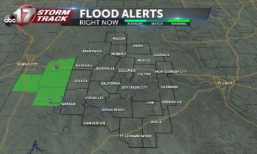
Tracking daytime showers and storms
TODAY: Showers and thunderstorms will stick around throughout the day but will be off and on. Highs will only top out in the low to mid 80’s thanks to rain-cooled air and plenty of cloud cover. TONIGHT: There are small chances for some showers to linger into the evening, but many of us will remain dry heading
Continue Reading
Tracking the return of some cool weather finally
MONDAY: Showers and thunderstorms have made a return this morning. These look like they’ll stick around throughout the day but will be off and on. Highs will only top out in the low to mid 80’s thanks to rain-cooled air and plenty of cloud cover. TONIGHT: Rain chances will stick around tonight, but won’t be
Continue Reading
Cold front bring rain and much cooler air Monday
TONIGHT: Rain and thunderstorm activity will increase towards morning. Temperatures drop into the low 70s. MONDAY: Scattered rain showers can be expected in the early morning because more widespread by 10am. A few rumbles of thunder are possible into the afternoon, with rain slowly decreasing into the evening hours. EXTENDED: The front will stall out to our
Continue Reading
Tracking one last hot day for a while
SUNDAY: Another warm one in store this afternoon. Temperatures will push back into the low 90’s, with the typical humidity keeping heat index values in the low 100’s. Some more afternoon spotty storms will be possible, but will be isolated in nature. TONIGHT: Storm chances stick around especially after midnight. Overnight lows fall into the
Continue Reading
Hot weekend leads to a cooldown next week
TONIGHT: Mostly clear and muggy. Lows in the low to mid-70s. SUNDAY: We can expect more of the same tomorrow. Temperatures will top out in the low 90s with dew points into the low 70s. Feels like temperatures will be in the 98-103º range. A spot shower or storm isn’t out of the question in
Continue Reading