Skip to Content

Weather

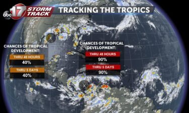
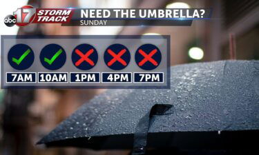
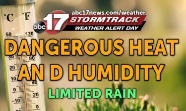
Tracking dangerous heat the next few days

TONIGHT: Mostly clear and muggy with lows in the upper 70s. TOMORROW: Hot and humid with highs in the upper 90s. Heat index between 104-107. EXTENDED: Intense heat continues most of this week with a heat index topping 105 tomorrow and getting close again on Wednesday. There’s a chance we may need to extend the WAD into Thursday, but

Continue Reading

Tracking weekend showers and storms

Today: Temperatures will continue to climb back into the lower 90’s this afternoon with winds returning out of the southwest at 10 mph. Skies remain mostly clear. Tonight: Temperatures continue the warming trend as the overnight lows top out near 70 degrees. Skies remain mostly clear. Extended: Heading into Friday, Central Missouri sees a stark

Continue Reading

Tracking a cool start to the week

Tonight: Winds will remain breezy out of the north overnight at 10-15 mph. Overnight lows will cool to the upper 50’s and lower 60’s. Skies remain partly cloudy. Tomorrow: Skies remain partly cloudy with winds out of the northeast helping aid our cooler afternoon highs into the lower 80’s once again. Extended: Tuesday Central Missouri

Continue Reading

Tracking a cooldown behind weekend showers

TODAY: Scattered showers and storms possible through midmorning. Northerly winds and clouds this afternoon keep highs in the low 80s. TOMORROW: Partly cloudy with winds continuing to flow in from the north. Highs top out in the mid-80s. EXTENDED: Below-average temperatures are in store through midweek thanks to a cold front currently digging south. Be

Continue Reading