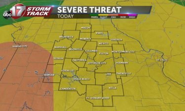
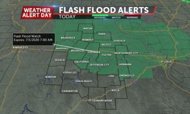
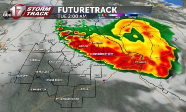
THE SCIENCE BEHIND: “Donut holes” on radar this morning
A meteorologist’s biggest fear when forecasting snowfall can be the effects that dry air can have on evaporating snowflakes before they reach the ground.
Continue ReadingA meteorologist’s biggest fear when forecasting snowfall can be the effects that dry air can have on evaporating snowflakes before they reach the ground.
Continue ReadingWatch a Wednesday afternoon update on weather conditions from Chief Meteorologist Jessica Quick in the player below SYNOPSIS Precipitation continues to ride up a stationary boundary bringing heavy snow to the Midwest and several other precipitation types furth south and east. PRECIP BREAKDOWN/TIMINGS Precipitation is starting to slow down to our west and that should
Continue ReadingHere's #KansasCity erupting in celebration, as detected by our radar! 🎉🎇🎆🏈 pic.twitter.com/IlfG82gxl6— NWS Kansas City (@NWSKansasCity) February 3, 2020 The National Weather Service in Kansas City posted a radar loop of a brief burst in their signal around the time the Chiefs were named Super Bowl champions. This can be a bit tough to see
Continue ReadingWe were off to such a good start… The end of 2019 and start of 2020 was one of the warmest stretches of weather to start the winter season ever in Mid-Missouri. This was coupled with plenty of sunshine, with many of us asking if winter was going to make a return after its quick
Continue ReadingBig changes are on the way after a week of cool, cloudy weather.
Continue ReadingMORNING UPDATE: Snow has been falling throughout the morning. The more consistent of the snow has been falling south of I-70, with a fairly impressive band along the Callaway-Osage county line. Radar estimates of snowfall amouts so far this morning. Let us know what you’re seeing where you are today through the share tab! Add
Continue ReadingIt’s fairly obvious that sunlight provides us warmth during the day. But, even in the heart of a snowstorm, with thick cloud cover and snow falling, it can have a dramatic effect on how snow accumulates.
Continue ReadingWinter Weather Advisories go into effect for the counties shaded in purple from 6pm this evening until 12pm. Synopsis A potent upper-level trough, which has already dropped 8-13″ of snow across the south-central plains is kicking eastward towards mid-Missouri this afternoon. Precipitation is expected to remain fairly light but steady overnight– higher accumulations are expected
Continue ReadingWinter weather advisories continue through 6 p.m. for our eastern counties. Light snow is expected to fall between 3 and 7 p.m. No additional accumulation is expected.
Continue ReadingSome of us have been upgraded from a Winter Storm Watch to a Winter Weather Advisory. A Winter Storm Watch is still in effect through late Friday night for the eastern half of Mid-Missouri as winter weather is expected to impact roads Friday morning.
Continue ReadingFreezing rain can be one of the most disruptive types of weather we can experience. It can cause havoc on roads and wipe out power over a widespread area. We’re going to show you how freezing rain forms and the impacts we can expect for Friday’s system. How we typically illustrate freezing rain This is
Continue ReadingSince the official start of winter on Dec. 21, things have been anything but winter-like in mid-Missouri. We tied our second-warmest Christmas. We also took second place for the warmest start to the season (between Dec. 21 and Jan. 13) based on average a 50.8-degree average high temperature. The only other year with a warmer
Continue ReadingSYNOPSIS: Snow continues to rotate out of mid-Missouri this evening. Most snowfall will exit our eastern counties by 7pm. Snow will continue to taper off with most of the area seeing 1-3″ total storm accumulation by sundown. In addition to the snowfall, temperatures stay below freezing with winds gusting up to 30 mph at times.
Continue ReadingEarlier this afternoon, the Army Corps of Engineers and National Weather Service Meteorologists met to discuss the latest flooding potentials and status on levee repairs. The meeting started out by outlining current conditions within the Missouri River Basin. Precipitation within the last month has been slightly above average across the forecast area. Thankfully, no major
Continue ReadingThe weather pattern will begin to take a turn late this week as a deep trough digs across the western half of the country Thursday. Southwest flow aloft will bring rich moisture into the Mississippi and Ohio River Valleys for an extended amount of time, setting us up for rounds of precipitation. A cold front
Continue ReadingIt’s no doubt been a mild start to the winter season. After snow and bitter cold on Veteran’s Day along with a 2 day marathon of snowfall in mid December. Since the start of winter on December 21st, high temperatures have averaged 57º! This is the 11th warmest start to winter (up to January 5th)
Continue ReadingEvery summer, Australia deals with wildfires due to westerly winds which draw desert air from the center of the nation. These “westerlies” are cause by a phenomenon called the Indian Ocean Dipole or “IOD.” The IOD is defined by a distribution of water temperatures across the Indian Ocean. The IOD can either be in positive,
Continue ReadingIf you have any whether questions, don’t hesitate to ask! luke.victor@kmiz.com or weather@kmiz.com I got a question in an e-mail on Tuesday– a viewer asked why river flood warnings get issued, and it may not come up in a news story or our weather forecasts. This viewer wondered if damaged levees were to blame. While
Continue ReadingA significant December thaw is underway across mid-Missouri with temperatures soaring into the mid 50s with plenty of sunshine Saturday. Another day of mild weather is on tap Sunday. A potent upper-level trough is expected to develop across the western United States this week. This will lead to strong southwesterly flow developing on top of
Continue ReadingAfter a wintry start to this week, the snow continues to melt, and it will feel more like spring across Mid-Missouri and much of the country through early next week. Locally, we have a quiet weekend for travel with clouds moving out by Saturday morning, and temperatures rising into the mid-50s by Sunday. Across the
Continue Reading