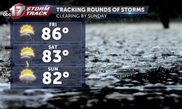
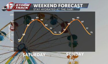
Skip to Content

Daily Forecast

Tracking one last cool day

THURSDAY: We’re getting off to the coldest start we’ve felt in a few weeks. High pressure is settling overhead, which will settle the winds down today, but won’t bring some warm air back until tomorrow. Highs today will top out in the upper 40’s and low 50’s again, even with a healthy dose of sunshine. TONIGHT: Those

Continue Reading

Tracking cooler air moving in

TUESDAY: We’ll wake up to more sunshine, but things will start changing by this afternoon. Clouds will start to increase as winds flip northwesterly behind the passage of a cold front early this afternoon. That will hold us in place, in the low 60’s today. Clouds will increase, but it’s looking like the rain holds off

Continue Reading

Tracking windy conditions

MONDAY: Another breezy afternoon will kick off a new week. Gusts as highs as 40 mph will be possible, and with plenty of dry fuels around, any fires outside could get out of hand fast. Try to avoid any outdoor burning today. Those winds will help push temperatures into the low-mid 70’s this afternoon. TONIGHT: Mostly clear

Continue Reading

Tracking a mostly clear weekend

TODAY: Many of us will see clear skies and a breeze with highs reaching the 70s this afternoon. A disturbance will slide by to the north in the morning that could bring showers but conditions will clear by the early afternoon. THIS EVENING: Unfortunately this warmth is gearing up ahead of a front moving through the SE

Continue Reading

Tracking an overall pleasant weekend

TONIGHT: A disturbance will move just to our north overnight. A few showers will be possible for a brief period north of I-70 in the predawn hours of Saturday but otherwise quiet. Lows will fall into the upper 40’s. TOMORROW: Saturday itself will be a gorgeous day for most of us, with a steady breeze and temperatures

Continue Reading
Skip to content