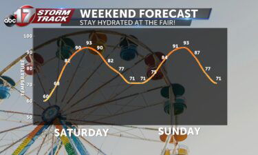
Skip to Content

Weather

Tracking summer-like conditions

TODAY: Mostly sunny and breezy with south wind gusts up to 30-35 mph. Highs in the low 80s. TONIGHT: Those winds will lighten up slightly, but you’ll want to keep the trashcan in the garage overnight. Lows will fall into the low 60s. EXTENDED: A warm front settling to our north to start the week

Continue Reading

Tracking a rainy end to the week

TODAY: Spot rain showers will be with us as we wake up this morning. We’re tracking the potential for some dry time around lunch, but showers and storms will move back in during the afternoon and evening. High temperatures will be in the mid-50s. TONIGHT: After those thunderstorms roll through, widespread rain is expected to

Continue Reading

Tracking the return of rain overnight

TONIGHT: Clouds will continue to increase ahead of our next rain chance moving in this evening. Showers will be possible anytime after sunset, but look more widespread overnight. Lows will be held in the middle 40’s. FRIDAY: Those showers will become more isolated during the morning commute, but return by the afternoon. A southerly breeze

Continue Reading

Tracking a chilly, yet pleasant day

TODAY: Morning frost followed by afternoon sunshine. Clouds return late in the day as winds shift southwest, bringing more moisture into the area. Highs in the upper 50s. TONIGHT: Low temperatures will fall into the lower 40s. Rain showers are possible from the late evening throughout the night. EXTENDED: A stronger low pressure system to

Continue Reading

Tracking a rare late April snow

MONDAY: A terrific start to the week! Temperatures will make it into the middle 60’s early this afternoon before backing up into the 50’s by the evening commute. We’ll be cloud-free to start but they’ll increase heading into the afternoon as a cold front moves through. Winds will turn northwesterly and could gust up to

Continue Reading
Skip to content