WINTER WEATHER BLOG: Snow and frigid temps make for tricky travel Sunday
Check back here Sunday for updates on Mid-Missouri conditions.
Continue Reading Check back here Sunday for updates on Mid-Missouri conditions.
Continue Reading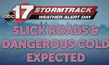
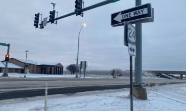
Sunday Morning Update: Icy and slick roads remain a concern this morning with temperatures in the teens and wind chills plummeting below 0 degrees. Expect poor travel conditions for the rest of the weekend and try to stay home as much as possible. Current road conditions for Mid-MO can be found here. Brutal Cold Temperatures
Continue Reading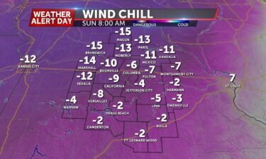
SUNDAY: A Weather Alert Day is in effect to end the weekend for dangerous cold conditions today. Snow flurries will be possible before sunrise with low temperatures falling into the single digits. Wind chills will plummet to the negative teens so stay indoors as much as possible today. Frostbite can set in in as little as
Continue Reading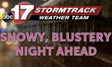
TONIGHT: Snow showers will be off and on at times until midnight as temperatures continue to plummet. They’ll bottom out in the upper single-digits, but with the wind keeping up, it will feel like 15 to 20 degrees below zero. Light accumulations will be possible but roads will continue to deteriorate throughout the evening and
Continue Reading
Officials are reporting roads and power outages are being impacted by winter weather across Mid-Missouri.
Continue Reading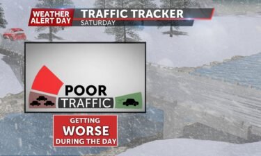
SATURDAY: A Weather Alert Day is in effect for New Year’s Day for impacts from a winter storm. Showers are moving through southeastern Missouri, with a transition to a wintry mix along and north of I-70. Far northern counties in our area are also likely to see snow near sunrise. As temperatures continue to drop throughout
Continue Reading
Emergency first responder crews are starting to prepare for the potential of severe weather on Saturday. According to Policy.net, about 900 people are killed in the US every year in vehicle crashes due to snow
Continue Reading
TONIGHT: A big warmup has temperatures pushing upper 50’s and low 60’s this afternoon. A big influx of warmth and moisture will end us warm with a chance for showers late tonight. These are part of a strong system that will pull in cold air early Saturday that will turn showers into a wintry mix
Continue Reading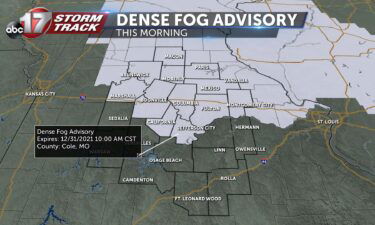
FRIDAY: A Dense Fog Advisory is in effect for the northern half of the area through midmorning. Visibility is reduced to less than 1/4 of a mile for some. A big warmup is in store for the final day of 2021; more sunshine today will boost highs to the upper 50s. SATURDAY: A Weather Alert Day
Continue Reading
TONIGHT: Partly cloudy skies remain this evening as some of the cloud cover from today tries to break apart. Temperatures drop into the middle 30’s. FRIDAY: Our next system approaches Friday, and we warm up big ahead of it. Partly cloudy skies and south winds jump temperatures into the high 50’s. Some may even see
Continue Reading
THURSDAY: Light fog is still persisting for the early afternoon but will fade out as temperatures warm up. Highs top out in the mid-40s. TONIGHT: Partly to mostly cloudy. A bit warmer with lows in the low 30s. EXTENDED: We get more sunshine to help out tomorrow, boosting temperatures into the 50’s to end 2021. Starting 2022 will
Continue Reading
COLUMBIA, Mo. (KMIZ) Columbia Public Works and Boone County Road & Bridge are preparing Wednesday for the wintry weather expected this weekend. The city and county could see snow, ice and freezing rain on New Year’s day. John Ogan, with Columbia Public Works, said they prepared to take the wintry mix on. “We’re ready for whatever
Continue Reading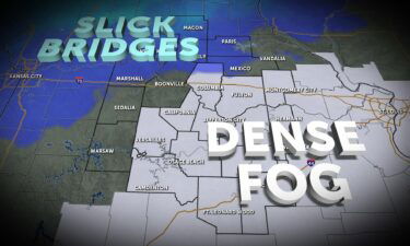
THURSDAY: Some patchy fog will cause some delays this morning, especially along and south of I-70. A few slick spots will be possible on bridges north of the interstate, so no matter where you’re headed this morning, build in some extra time. Temperatures will struggle to warm up as much this afternoon, only reaching the
Continue Reading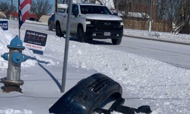
A winter storm is expected to hit the region this weekend, bringing chances for snow and ice along with brutal winter cold, forecasters say.
Continue Reading
TONIGHT: Ongoing showers and flurries will come to an end this evening as moisture shifts to the east tonight. Temperatures will linger in the 30’s through the night into early Thursday. THURSDAY: Drier conditions are in store for Thursday, but clouds stick around in some respect. Still some sunshine will make Thursday overall brighter with
Continue Reading WEDNESDAY Many of us are still working on drying out but we’re tracking another round of showers on the way. Timing will be towards the mid to late morning through the afternoon hours, but should generally stay south of I-70. Temperatures will be stuck in the 30’s for much of the day, topping out near
Continue Reading
WEDNESDAY Many of us are still working on drying out but we’re tracking another round of showers on the way. Timing will be towards the mid to late morning through the afternoon hours, but should generally stay south of I-70. Temperatures will be stuck in the 30’s for much of the day, topping out near
Continue Reading
TONIGHT: Mostly cloudy with lows in the lower 30s. Gusty west winds up to 25 mph. TOMORROW: Chance of showers south of I-70, with mostly cloudy skies. Highs in the lower 40s. EXTENDED: A low pressure system sliding to our south Wednesday will bring the threat of showers to our southern counties into Wednesday afternoon
Continue Reading
TUESDAY: Showers and a few rumbles of thunder will be with us throughout the morning. A good, soaking rain will leave us with around an inch of rain before departing this afternoon. Sunshine will even try to visit after the rain, bumping temperatures into the middle 50’s. TONIGHT: Clouds will increase tonight ahead of our
Continue Reading
TONIGHT: Mostly cloudy with showers possible well after midnight. Lows in the upper 30s. TOMORROW: Showers likely through mid-late afternoon with highs in the low to mid-50s. Rain amounts between 1-1.5″ for much of the area. Breezy, with wind gusts between 25-30 mph. EXTENDED: Rain showers will likely begin from south to north ahead of
Continue Reading