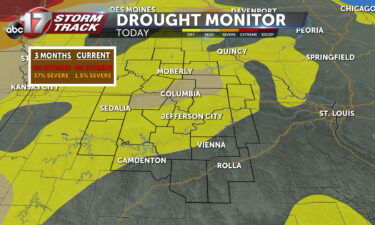
Skip to Content

Weather

Tracking chilly rain the next few days

TONIGHT: Mostly cloudy with lows near 50. Getting breezy with winds up to 30 mph out of the south. TOMORROW: Mostly cloudy and breezy with highs in the lower 60s. Rain moves in by late afternoon. EXTENDED: Clouds start moving in tonight, keeping temperatures trapped around 50 degrees overnight. Tomorrow is breezy and cloudy with rain moving in

Continue Reading

Insider Blog: Recent severe weather a reminder to always have more than one way of receiving alerts

Some Pettis County residents voiced concerns over the timeliness of tornado sirens during Sunday’s storms. The ABC 17 StormTrack Weather Team was tracking the storm that spawned two EF-0 Tornadoes on the outskirts of Sedalia on Sunday. This particular storm developed rotation rather quickly. Shortly after the storm started showing signs of rotation, the National

Continue Reading

Tracking Severe storms Sunday afternoon

Tonight: Scattered Showers and storms will continue to form along a warm front moving from southern Missouri towards northeastern Missouri. The greatest threat with these storms tonight will be heavy downpours and some isolated strong winds with lightning. Showers and storms park over northern Missouri into the late evening leading to impressive rainfall totals between

Continue Reading
Skip to content