
Wilkes Boulevard United Methodist Church to provide warming center for Columbia’s homeless
A central Columbia church will be the site of an overnight shelter for homeless people this winter.
Continue Reading A central Columbia church will be the site of an overnight shelter for homeless people this winter.
Continue Reading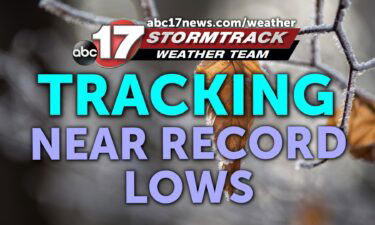
TONIGHT: Mostly clear and cold with light winds. Lows falling into the lower 20s. TOMORROW: Increasing clouds and a bit warmer with highs in the lower 50s. EXTENDED: Tonight, winds die down enough to allow temperatures to dip into the low 20s once again. I’ve dropped our forecast to 22, which would tie the record
Continue Reading
Temperatures are continuing too cool as we head deeper into the fall season. This also means the relative humidity will also decrease on average as the days continue. Throughout summer, increased levels of moisture in the atmosphere allow for charges to be dissipated more regularly from the human body. This means excess positive protons are
Continue Reading
Today: Temperatures remain nearly 20 degrees below average this afternoon as highs increase slightly to the upper 40s. Skies remain mostly sunny with winds gusting up to 22 mph. Tonight: Temperatures continue to fall dramatically as winds remain out of the northwest. Overnight lows cool to the lower 20s with mostly clear skies. Extended: Temperatures
Continue Reading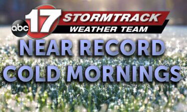
TODAY: Tuesday is a bitterly cold start with morning lows near record territory in the 20s and afternoon highs climbing into the upper 40s. Generally, winds are from the north, sustained around 10-15 mph, gusting to 20 mph. Skies remain clear. TONIGHT: Skies stay clear overnight, and winds relax to around 5 mph. We’ll start
Continue Reading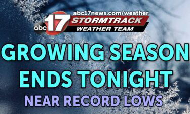
TONIGHT: Mostly clear and breezy with temperatures in the mid-20s. TOMORROW: Mostly sunny and chilly with highs in the upper 40s. EXTENDED: Tonight, winds will die down a bit, but even the 10 mph breeze will bring wind chills down into the mid-upper teens by daybreak. Overnight lows could get close to records with the
Continue Reading Temperatures are looking to cool into the mid to lower 20’s throughout all of Mid-Missouri the next two nights leading to a freeze warning being issued by the National Weather Service offices throughout Missouri. A freeze warning typically only occurs once during the fall due to below freezing temperatures for a prolonged amount of time.
Continue Reading Today: Temperatures continue to remain well below average as afternoon highs top out into the upper 40s. Winds remain out of the northwest sustained at 10-15 mph with gusts up to 25 mph. Skies remain mostly clear. A Red Flag Warning remains in effect for the southern half of the viewing area due to dangerous
Continue Reading
TODAY: Monday starts the week on a cooler note. With winds from the north, sustained near 10-15 mph and gusting in as high as 20-25, temperatures will struggle to get out of the 40s despite abundant sunshine. With wind chill, it feels like low 40s at best. TONIGHT: Winds will relax, but maintain a breeze
Continue Reading Tonight: Winds remain gusty out of the northwest up 20 mph as overnight lows cool to the lower 30s. Skies remain mostly clear. Tomorrow: Monday begins the week with afternoon highs well below average near 50 degrees. Winds remain out of the northwest at 8-12 mpg with gust up to 24 mph. Skies remain mostly
Continue Reading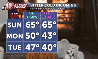
Today: Breezy and seasonable with temperatures starting out in the lower 40s. Despite northerly winds, we’ll still climb to the upper 60s this afternoon. Wind gusts reach up to 20 mph. Tomorrow: Early morning temperatures in the 30s; gusty conditions push the wind chill down to the lower 20s. Highs struggle to reach the upper
Continue Reading Tonight: Winds switch back out of the northwest past midnight tonight as overnight lows cool to the upper 40s. Tomorrow: Temperatures remain into the mid-60s as winds gust up to 20 mph from the northwest. Skies remain mostly sunny. Extended: A steep cooldown is in store beginning Sunday night. Strong winds out of the northwest
Continue Reading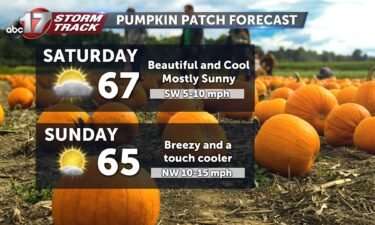
Today: Macon and Monroe counties are in a Frost Advisory through 8 AM Saturday morning, and farther south we’ll dip into the upper 30s by daybreak. Mostly sunny to start with increasing clouds through the afternoon. Highs in the upper 60s. Tomorrow: Breezy and cooler as highs drop to the mid-60s. Wind gusts up to
Continue Reading
TONIGHT: Becoming mostly clear and cold with lows in the upper 30s. TOMORROW: Mostly sunny to start with increasing clouds through the afternoon. Highs in the upper 60s. EXTENDED: We’re tracking a disturbance that is trying to bring a few showers to areas north of I-70, but we have such dry air in place that
Continue Reading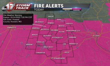
TODAY: Friday is another dry and windy day, with sustained winds in the 15-20 mph range, and gusts as high as 30 mph. Steady sunshine will lower humidity enough that critical fire weather will again be in place for most. Read more on that here. By the late afternoon, a boundary slides in from the north
Continue Reading
TODAY: Friday is another dry and windy day, with sustained winds in the 15-20 mph range, and gusts as high as 30 mph. Sunshine early in the day will help lower humidity enough that critical fire weather may again be in place for most. Read more about that here. By noon, a boundary slides in
Continue Reading
UPDATES FRIDAY MORNING UPDATE: As of early Friday morning, Red Flag Warnings have been put in place just about areawide. The only county outside of today’s Red Flag Warnings is Macon, where burning may still be dangerous, but incoming clouds may be enough to keep relative humidity out of critical territory. BLOG FIRE ALERTS: Fire
Continue Reading
TONIGHT: Mostly clear and breezy, lows in the upper 30s. TOMORROW: Mostly sunny and windy, highs in the lower 70s. EXTENDED: Dangerous fire weather conditions developed across much of the state with wind gusts this afternoon reaching 30-35 mph along with very low dew points. Avoid any outdoor burning again tomorrow as winds are expected
Continue Reading
TODAY: The word of Thursday’s forecast is GUSTY. Winds will gradually turn from westerly to northwesterly into the afternoon, while sustained near 15-20 mph. Gusts will range from 25-35 mph this afternoon. Partner this with a relative humidity below 20% and we have a recipe for dangerous fire behavior. The National Weather Service offices in
Continue Reading
TONIGHT: Passing clouds with cooler temperatures settling in. Gusty winds up to 20 mph will help drop temperatures into the lower 40s. TOMORROW: Mostly sunny and breezy with highs in the mid-60s. EXTENDED: A few clouds slide by tonight with a weaker, dry front moving in overnight. That will help drop temperatures to the low
Continue Reading