
Weather Alert Day: Severe storms with hail, wind and tornadoes possible Friday; tornado watch in effect
Mid-Missouri is now under a tornado watch through 8 p.m.
Continue Reading Mid-Missouri is now under a tornado watch through 8 p.m.
Continue Reading
TONIGHT: Clearing and colder as storms exit. Strong winds could gust up to 45 mph at times. Lows in the upper 30s. TOMORROW: Partly sunny and breezy with highs in the mid-50s. Gusts up to 30 mph possible early in the day. EXTENDED: Storms exit Mid-Missouri early this evening, but temperatures decrease into the upper
Continue Reading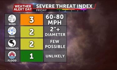
TODAY: Friday is a Weather Alert Day for the threat of severe storms bringing multiple hazards to Mid-MO. For a detailed write-up on this system, click here to read our Weather Alert Day Blog. We’ll climb into the 70s through the early afternoon and with this warmth comes thunderstorms chances. Spotty showers and storms will likely
Continue Reading
TODAY: Friday is a Weather Alert Day. Temperatures are starting in the 50s this morning, with breezy conditions amid a wind from the south. This south wind will serve to keep us warming quickly again today. We’ll climb into the 70s through the early afternoon. This warmth comes with thunderstorms chances. Spotty showers and storms
Continue Reading
TONIGHT: Mostly cloudy and breezy with a chance for a few spotty storms overnight. Lows in the upper 50s. TOMORROW: Mostly cloudy to start, with strong storms potentially developing west to east by mid-afternoon. Storms will bring the potential of damaging winds, large hail, and a few tornadoes. Highs reach the mid-70s. A Wind Advisory
Continue Reading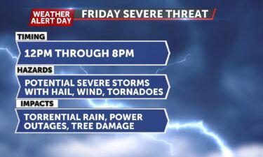
TODAY: Clouds will slowly fill in this afternoon as temperatures rise to the 60s. With the clouds come scattered showers and storms arriving in our southwest counties around mid-afternoon. TONIGHT: Clouds fill in overnight, and so do scattered showers and storms. Not much rainfall is expected but hit-and-miss activity persists through the morning. Temperatures hardly
Continue Reading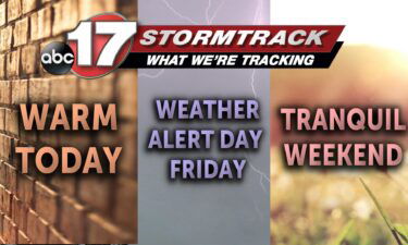
TODAY: A warm front is lifting through the region this morning, with warmer air following quickly behind it. We’ll start with sunshine this morning, with more cloud cover arriving later this afternoon. With the clouds, comes scattered showers and storms. These arrive in our southwest counties, meaning the lake area around mid afternoon, so be
Continue Reading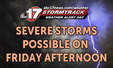
TONIGHT: Partly cloudy with lows in the upper 30s to around 40. TOMORROW: Partly sunny and breezy with highs in the upper 60s to near 70. Winds could gust to 25 mph. EXTENDED: Strong south winds help increase moisture across the region as a warm front lifts to our north. Temperatures reach into the upper
Continue Reading
TODAY: A stationary front overhead is barely noticeable with abundant sunshine this afternoon. As we’re on this boundary’s southern, warmer side, highs will rebound into the upper 50s today.TONIGHT: Skies remain partly cloudy overnight, with variable winds at the surface. Those who keep south winds in the southern half of the region will stay near
Continue Reading
TODAY: Temperatures near freezing this morning will warm into the upper 50s with partly cloudy skies and an increasingly south wind through the day. A stationary front will wobble nearby, just north of I-70 through the day, bringing a brief wind shift for some this afternoon from the north. This will keep some in the
Continue Reading
TONIGHT: Mostly clear and cold with lows in the upper 20s to lower 30s. TOMORROW: Partly sunny and warmer with highs in the upper 50s. EXTENDED: Clouds gradually clear out as rain has exited to our east today, with high pressure building in overnight into Wednesday. As that slides south, winds will shift back to
Continue Reading
TODAY: Showers early on Tuesday will start to exit the region to the east after bringing light rain and a few snowflakes, by sunrise. Everyone will be dry by around noon. Clouds will clear behind this rain, and leave us with sunshine this afternoon. This should be just enough to push our temperatures into the
Continue Reading
We’re entering the prime time of year for severe weather in this part of the country.
Continue Reading
TONIGHT: Increasing clouds and chilly with lows falling into the upper 30s. Scattered showers developing late and continuing into early morning. TOMORROW: Morning showers moving out before midday, sunshine returning with highs in the lower 50s. EXTENDED: As showers exit on Tuesday morning, we’ll be left with decreasing clouds during the day. High pressure returns
Continue Reading
Often you hear meteorologist talking about high pressure systems and low pressure systems, but what do these systems actually do to our local weather? Looking at the ABC 17 Stormtrack Radar, southwestern portions of United States you’ll see a blue H, that’s going to be an indicator for high pressure. The radar also indicates a
Continue Reading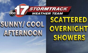
TODAY: Monday is another mild and bright day. Clouds and rain showers are exiting east this morning, leaving some low clouds and a northerly breeze. Any remaining clouds will break up and clear out early today. Temperatures land in the low 50s, with a continued north breeze keeping us from warming under a late March
Continue Reading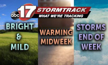
TODAY: Monday is another mild and bright day. Clouds and rain showers are exiting east this morning, leaving some low clouds and a northerly breeze. Any remaining clouds will break up and clear out early today. Temperatures land in the low 50s, with a continued north breeze keeping us from warming under a late March
Continue Reading
TONIGHT: Mostly cloudy and chilly with a few showers near I-44. Lows falling into the lower 30s. TOMORROW: Partly sunny and cooler with highs in the lower 50s. EXTENDED: A weak front to our north will help shove a fast moving disturbance through Mid-Missouri tomorrow night, bringing a chance for a few showers Monday night
Continue Reading
TODAY: Highs are mild again in the upper 50s with a few added clouds from a passing cold front. This disturbance won’t be able to produce rainfall until near sundown, with light showers mostly confined southeast of Hwy 54. Trace to a few tenths of an inch of rain is possible with rain exiting before
Continue Reading
TONIGHT: Temperatures dropping back down into the low 40s by the end of the night, with possibilities for light showers. These chances are extended into early tomorrow morning. TOMORROW: Temperatures warming back up into the higher 50s with partly cloudy skies. Winds at 10-15 mph from the WSW. Tomorrow night the area could also see
Continue Reading