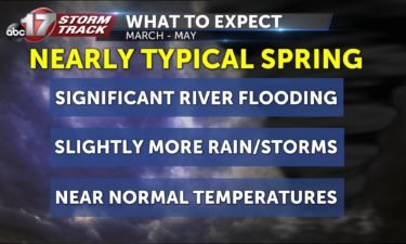
Active weather expected along with significant river flooding this spring
The newest data shows an increased potential of moderate flooding in many Mid-Missouri locations.
Continue Reading The newest data shows an increased potential of moderate flooding in many Mid-Missouri locations.
Continue Reading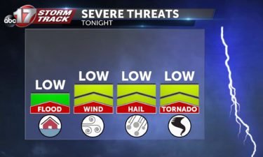
TONIGHT: Scattered thunderstorms. Some could be strong with gusty winds and isolated large hail. Storms clear out by midnight. Lows in the upper 30s. TUESDAY: Partly to mostly sunny, highs in the mid-50s. EXTENDED: Another low pressure system to our south slides by Tuesday night into Wednesday, bringing the potential of steady rainfall and embedded
Continue Reading
Year-round standard time in Missouri would lead to sunrises as early as 4:43 a.m.
Continue Reading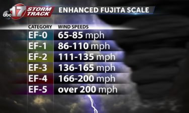
You know tornadoes are categorized using “EF,” but what does that mean?
Continue Reading
THIS AFTERNOON: Rain chances will slowly diminish this afternoon, but a line of thunderstorms is expected to develop after 6:00pm near HWY 65 and move east across mid-Missouri. Expect a chance of storms between 6:00-10:00pm tonight. A gusty wind or small hail is possible. Severe threat is low, but non-zero. TONIGHT: Rain & storms end from
Continue Reading
MONDAY: Showers will greet us out the door and will stay with us throughout the day. A few rumbles of thunder look to be possible as the front makes its move through the area toward this afternoon with highs nearing 60. It will be breezy again with gusts up near 35 mph. TONIGHT: Rain ends
Continue Reading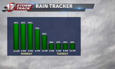
TONIGHT: Clouds will begin moving into the area during the evening,and rain will follow soon after. Overnight lows will be in the lower 50s. TOMORROW: Rain continues all day long, and we are tracking the possibility for some thunderstorms to develop in the afternoon. These storms do not look to be severe, but we’ll be tracking
Continue Reading
The ABC 17 Stormtrack Severe Weather Special airs Tuesday, March 10th at 6:30 p.m. on ABC 17, KMIZ. It will re-air on FOX 22, KQFX at 9:30 p.m. on that same day. In the special, the Stormtrack Weather Team will break down how they issue Weather Alert Days for severe weather. We’ll also be going
Continue Reading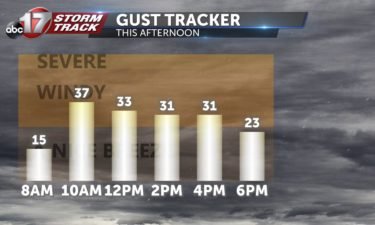
SUNDAY: Another warm and sunny day is in store with sunny skies and highs in the upper 60’s. It will be quite breezy with winds from the south gusting up to 30 mph. Due to the breezy and dry conditions, we will be under another Red Flag Warning (or potential fire hazard warning) meaning you
Continue Reading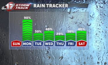
TONIGHT: Partly cloudy with lows in the low 40’s. A southerly breeze will persist throughout the night at about 10-15 mph. TOMORROW: Warmth continues with high temperatures near 70 degrees across mid-Missouri. Clouds will stay out of the area until late Sunday night, but then the first of many rain chances for this week is presented.
Continue Reading
SATURDAY: Mostly sunny with highs in the middle 60’s. SATURDAY NIGHT: Partly cloudy with lows in the low 40’s. EXTENDED: Sunday will be another gorgeous day that may make waking up an hour early not so bad! We will be sunny again and have our high temperatures possibly reach 70 degrees. However, after all the
Continue Reading
TONIGHT: Mostly clear and chilly with lows in the low 30s. SATURDAY: Mostly sunny and breezy with highs in the low 60s. EXTENDED: The nice weather continues through Sunday as winds and clouds increase. Temperatures rise into the upper 60s to around 70 for highs. With gusty winds and low humidity, the potential for fire
Continue Reading
Based on feedback I figured I'd alter some possible answers! Questions remains the same– To DST or not to DST…— Luke Victor 🌨️🌨️📈 (@LukeVictorWx) March 6, 2020 Prepare your clocks (and your eyelids) for the time change incoming this weekend. Daylight saving time will shift clocks forward one hour– that’s happening early Sunday morning. Don’t
Continue Reading
FRIDAY: Mostly sunny skies look to stick around through this afternoon. Highs will be a bit cooler, in the low 50’s but winds won’t be as breezy today. TONIGHT: Mostly clear skies overhead will help get temperatures into the low 30’s. EXTENDED: Winds will swing out of a more southerly direction into Saturday, which will
Continue Reading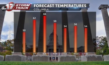
TONIGHT: Mostly clear and breezy with lows in the low 30s. FRIDAY: Mostly sunny and breezy with highs in the upper 40s to around 50. EXTENDED: High pressure keeping things cooler on Friday will slide southeast, leaving us with winds shifting back to the south for the weekend. Temperatures top in the low 60s on
Continue Reading
Red flag warnings expired across mid-Missouri this evening at 6:00 pm, but the dry and very windy conditions help fuel fire dangers across the region this afternoon. You may be wondering, especially with how wet this winter was, how we could possibly be dry enough to see brush fire dangers. Even when we consider elevated
Continue Reading
THIS AFTERNOON: A cold front will move in along with gusts in the 30-40 mph range. These windy conditions along with dry Winter vegetation will lead to dangerous fire conditions today. TONIGHT: Those winds stick around overnight, pushing in some cooler air as lows fall into the low to mid 30s. EXTENDED: Cooler air settles in for Friday
Continue Reading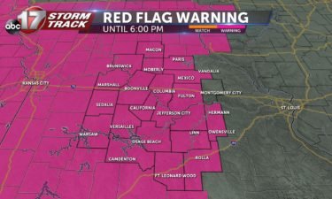
THURSDAY: Clouds will finish up thinning out this morning, bringing us a return to sunny skies that should last throughout the day. Highs will reach into the upper 50’s and low 60’s again, but it will be windy. A cold front will move in along with gusts in the 30-40 mph range. These windy conditions
Continue Reading
TONIGHT: Decreasing clouds, chilly. Lows in the upper 30s. THURSDAY: Breezy and brighter. Winds gusting up to 30mph from the northwest. Highs reaching near 60. EXTENDED: Canadian high pressure begins to settle in on Thursday into Friday, bringing high temperatures down about 10 degrees on Friday afternoon. We’ll still have ample sunshine but it’s a
Continue Reading
With dual-polarization radar coming about in the early 2010s, we can now confirm when a tornado is doing damage. This helps out tremendously when tracking nighttime tornadoes.
Continue Reading