
Wednesday’s UV index and pollen tracker
The UV index will shoot back up to a level 8 with sunburn times between 20-30 minutes. Pollen levels will be sky high, with mold being the primary allergen.
Continue Reading The UV index will shoot back up to a level 8 with sunburn times between 20-30 minutes. Pollen levels will be sky high, with mold being the primary allergen.
Continue Reading
Tonight: Two rounds of showers and storms will continue to make their way through Central Missouri tonight. The main threats will be strong winds up to 60 mph and hail up to 1″ in diameter. Strong downpours will also be associated with tonight’s storms. The driving force for tonight’s storm will be a cold front
Continue Reading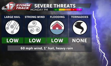
This Afternoon: A cold front is currently pulling southerly winds into Mid-MO, ramping up the heat and humidity. The feels-like dwells in the mid-90s while pop-up storms fire up all afternoon. The strongest of these will carry a risk of small hail and wind gusts above 50 mph – the severe threat is overall low,
Continue Reading
TODAY: Similar to Sunday morning, Monday starts in the 70s, with a muggy feel to the air. Monday presents as a slightly warmer day overall, with another round of scattered thunderstorms expected this evening. The first half of the day looks dry under partly cloudy skies. Temperatures climb to near 90 before storm chances increase
Continue Reading Tonight: Showers and storms will continue to push to the southeast with a few isolated showers remaining along or south of I-44. Overnight lows cool to just above 70 degrees with winds out of the southwest. Tomorrow: A few isolated storms will begin to the southeast of I-44 by the early morning hours. As noon
Continue Reading
Today: Dry at sunrise but storms approach from the west by midmorning. Take a lot of caution heading to the Lake of the Ozarks with a widespread round of storms tracking through the area from late morning to midafternoon. Storms mostly exit east by 4-5 pm with more scattered showers around I-44 overnight. Highs reach
Continue Reading Tonight: Isolated storms remain throughout Mid-Missouri the first half of the night. The main threats will be brief downpours and some lightning. Overnight lows cool to the lower 70’s as winds remain out of the south at 5-10 mph. Tomorrow: The morning and early afternoon hours of Sunday look to become partly cloudy with highs
Continue Reading
Today: Hotter than much of the past week with highs near 90. Humidity stacked on top of the heat will keep the feels-like in the lower 90s. Widely isolated storms are possible during the afternoon, becoming more scattered approaching sundown. Tomorrow: Lingering showers in the early morning and a mild start near 70 degrees. Depending
Continue Reading
This Afternoon: Similar to the past few days, partly cloudy with highs in the upper 80s. Tonight: A few passing clouds, otherwise perfect to head to the football field! More mild overnight with lows in the upper 60s. Extended: Plenty of dry time is in store Saturday, and temperatures climb to near 90. Humidity does
Continue Reading
TODAY: Friday starts mostly clear with temperatures in the 60s. Today feels not much different than yesterday, with the exception of a north wind that has us feeling a few degrees cooler. Overall, Friday is partly cloudy, with highs in the upper 80s. TONIGHT: Low level cumulus clouds will dissipate, but high clouds move in
Continue Reading
TONIGHT: Isolated shower or storm through about sunset, partly cloudy otherwise. Lows in the mid-upper 60s. TOMORROW: Partly to mostly sunny with highs in the upper 80s. EXTENDED: A cold front is draped across the northern half of the state and could trigger a few isolated showers or storms through sunset. Outside of that, we
Continue Reading
TODAY: We’re waking up to another familiar start this morning. Temperatures in the mid 60s under mostly clear skies to start will give way to a warm up to near 90 this afternoon. Clouds will increase throughout the day. A field of low to mid level cumulus clouds will likely develop, but also a cold
Continue Reading
DROUGHT MONITOR: The drought monitor is a product collaboratively produced by various government agencies and other organizations, to keep tabs on how dry (or not) communities are around the country. The product is updated every Thursday morning based on data collected through Tuesday morning of the same week. This means the drought monitor is updated
Continue Reading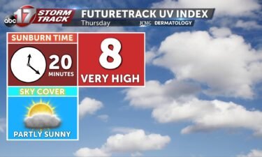
The UV index will be high, with sunburn times between 20-30 minutes. Pollen levels will continue to be high through the weekend, with mold being one of the predominant allergens.
Continue Reading
TONIGHT: Mostly clear with lows falling into the mid-60s. TOMORROW: Partly sunny with a few showers and storms possible by afternoon north of I-70. Highs in the upper 80s to around 90. EXTENDED: Winds will begin shifting to the southwest tomorrow, bringing heat and humidity back to Mid-Missouri for the next few days. A cold
Continue Reading
THIS AFTERNOON: Another beautiful day with partly cloudy skies and highs in the mid-upper 80s. TONIGHT: Skies clear overnight, with temperatures falling into the mid-60s. EXTENDED: Remnant thunderstorms out of a cold front to our north may brush into Mid-Missouri early Thursday but much of the day is expected to be dry. As this front
Continue Reading
TODAY: Another copy and paste day for Wednesday with very similar weather to Monday and Tuesday. Expect partly cloudy skies with highs in the mid-80s this afternoon. TONIGHT: Skies clear overnight, with temperatures falling into the mid-60s. EXTENDED: By early Thursday morning, clouds are starting to move in from the north, along with the possibility
Continue Reading
TONIGHT: Mostly clear and comfortable with lows in the low to mid-60s. TOMORROW: Partly to mostly sunny with highs in the mid-upper 80s. EXTENDED: A few clouds will roll in tonight, but it’s still a nice night with lows falling into the lower 60s. Tomorrow is another nice day with highs near our seasonal average
Continue Reading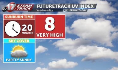
Tomorrow’s UV index will be high with a few clouds in the forecast. The pollen levels will be very high this week as ragweed counts spike.
Continue Reading Today: Temperatures look to continue to rise into the mid-80’s this afternoon with skies remaining partly cloudy. Pollen levels look to remain very high with weed pollen being the primary allergen. Winds vary but remain calm at 5 mph. Tonight: Temperatures look to fall into the mid to low 60’s as skies remain partly cloudy.
Continue Reading