
Friday’s UV index and pollen tracker
The UV index will be high with plenty of sunshine on Friday. Pollen levels will be high all weekend and drop slightly on Monday with rain in the forecast. in
Continue Reading The UV index will be high with plenty of sunshine on Friday. Pollen levels will be high all weekend and drop slightly on Monday with rain in the forecast. in
Continue Reading
This Afternoon: Partly cloudy skies with a pop-up storm possible near the I-44 corridor. Heat index in the mid-90s. Tonight: Temperatures falling to the low 70s. Patchy fog is possible early Friday again in the coolest areas. Extended: Southerly winds take over on Friday, and with clear skies, this will bump temperatures back into the
Continue Reading
DROUGHT MONITOR: The drought monitor is a product collaboratively produced by various government agencies and other organizations, to keep tabs on how dry (or not) communities are around the country. The product is updated every Thursday morning based on data collected through Tuesday morning of the same week. This means the drought monitor is updated
Continue Reading
TODAY: Rain ongoing this morning across the southern third of our counties will continue to push south during the pre-dawn hours. Most will find themselves dry by sunrise, but not before receiving copious amounts of rainfall. There may also be some patchy dense fog across the region with still and moist air sitting at the
Continue Reading
The Stormtrack Weather Team has issued a Weather Alert Day through late tonight for the threat of severe storms and potential flash flooding. A Severe Thunderstorm Watch is in effect for much of Mid-Missouri through 9:00 p.m., and a Flood Watch is in effect until 10:00 a.m. Thursday for areas along and south of I-70.
Continue Reading
The UV index will continue to be high Thursday as rain exits the area early. Pollen levels will be lower on Thursday, but rebound as winds and temperatures increase into the end of the week.
Continue Reading
TONIGHT: Scattered storms with heavy rain and gusty winds. Rain amounts between 2-4″ possible. Lows in the lower 70s. TOMORROW: Patchy fog in the morning with sunshine returning for the afternoon. Highs in the upper 80s to around 90 with a heat index in the upper 90s. EXTENDED: A slow moving cold front will trigger
Continue Reading
A Weather Alert Day is in effect through Wednesday evening as dangerous heat continues to be a problem. Heat index values could reach 105 this afternoon and yet again on Wednesday afternoon. We’re on the edge of a dome of high pressure at the upper levels of the atmosphere. This, for the most part is
Continue Reading
TODAY: Starting in the mid-70s, warm temperatures will be a theme again today. Today is a Weather Alert Day as feels like temperatures reach as high as 105 today. A Heat Advisory is in place through this evening. A cold front will move in this afternoon, bringing widespread chances for storms, but it won’t arrive
Continue Reading
TONIGHT: Mostly clear and muggy with lows in the upper 70s. TOMORROW: Mostly sunny early with heat indices between 103-106. Scattered showers and storms moving in by late afternoon. A few storms may be severe with strong winds and heavy rain. EXTENDED: Heat and humidity hold on through Wednesday as winds from the south push
Continue Reading
The UV index continues to be high on Wednesday with sunburn times between 20-30 minutes. Pollen levels will be high through the end of the week with little rain in the forecast after today.
Continue Reading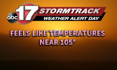
TODAY: Tuesday is another heat related Weather Alert Day. We have temperatures this afternoon, expected in the high 90’s. This partnered with dewpoints still near 70 for some, will result in heat index values close to, if not greater than 105. Some will miss out where there is lesser humidity (near the lake), but almost
Continue Reading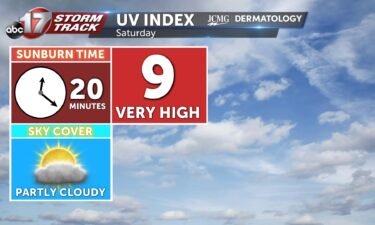
The UV index will increase Tuesday afternoon with less cloud cover. Pollen levels will rise this week with the lack of rain and windier conditions.
Continue Reading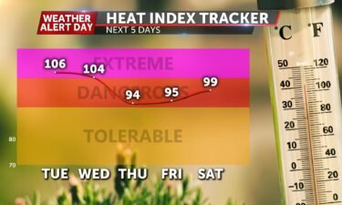
Tonight: Temperatures will slowly fall to the mid-70’s for the overnight low. Skies look to become partly cloudy with winds out of the southwest. Tomorrow: A Weather Alert Day has been issued beginning at 5 AM lasting through 7 PM Tuesday due to high heat index values between 105-107 degrees across much of Mid-Missouri. Early
Continue Reading
TODAY: Heat returns Monday, as temperatures soar into the mid 90s. Thanks to a south wind both at the surface, and further up in the atmosphere, a big influx of warm air will leave us feeling considerably warmer than Sunday. With temperatures in the mid 90s, and dewpoints near 70, heat index values will likely
Continue Reading Tonight: Skies remain partly cloudy tonight as winds return back out of the southwest at 4-8 mph. Overnight lows drop to the lower 70’s. Tomorrow: With help from mostly sunny sky conditions and winds out of the southwest, highs increase back to the mid-90’s Monday as the heat index tops out near the 100 degree
Continue Reading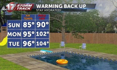
TODAY: Isolated showers and storms are possible across the southern half of the area early in the day. Skies clear up in the afternoon with highs in the mid to upper 80s. TOMORROW: Summer heat returns quickly as highs jump to the mid-90s. Low chance for storms in the late afternoon. EXTENDED: High pressure building
Continue Reading Tonight: Scattered showers will continue across the southern half of Central Missouri. Areas along and south of highway 70 will see light showers as overnight lows cool to the upper 60’s. Winds remain out of the southeast at 4-8 mph. Tomorrow: Isolated storms and scattered showers will re-flare up across the southern half of the
Continue Reading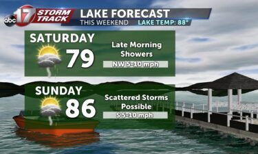
TODAY: Partly cloudy with a chance for afternoon showers near the Lake of the Ozarks. Highs in the lower 80s. TOMORROW: Isolated showers possible throughout the day with highs warming slightly to the mid-80s. EXTENDED: By Monday, heat sets back in as a warm front lifts north of us and upper high pressure builds overhead.
Continue Reading Tuesday morning the 26th would see record breaking flooding in the St. Louis region thanks to a stationary front stalling strong showers and storms overhead. Totals would surpass a foot in some areas leading to two deaths. This same system that brought so much rainfall to Missouri has now moved to the southeast causing more
Continue Reading