
Tipton storm damages homes, takes out electricity
Storms ripped through Tipton in the early morning hours Friday leaving residents to wake up to damage.
Continue Reading Storms ripped through Tipton in the early morning hours Friday leaving residents to wake up to damage.
Continue Reading
TODAY: Temperatures are starting warm again Friday. Rain ongoing across the area earlier this morning, will add to any humid feeling at the surface. At the same time, behind the rainfall, winds will generally shift more northerly, lending to an overall cooling effect today. Expect highs in the upper 80s to low 90s from north
Continue Reading
Despite morning storms, the UV index will recover and register at a 9 on Friday, meaning the sunburn time will be between 20-30 minutes. Pollen levels will continue to be low through early next week as winds will shift to the north.
Continue Reading
TONIGHT: Mostly cloudy with scattered showers and thunderstorms after sunset. A few storms may become severe with the potential of strong winds, heavy rain, and large hail. TOMORROW: Mostly cloudy with a few storms possible. Highs in the upper 80s to around 90. EXTENDED: As a disturbance rolls along a stalled front draped across Mid-Missouri tonight,
Continue Reading
BLOG: The ABC 17 Stormtrack Weather Team has issued a Weather Alert Day through late tonight as the threat for severe storms increases this evening. Storms with the potential of producing large hail, damaging winds, and the threat of an isolated tornado. SETUP: An active upper pattern has developed rounds of storms across the upper
Continue Reading Today: The heat index is set to surpass 100 degrees once again in the southern third of Central Missouri with dewpoints into the lower 70’s. The northern 2/3’s of the viewing areas has seen morning showers and cloud cover enabling cooler temperatures. The afternoon high in Columbia is set to top out at 90 degrees.
Continue Reading
TODAY: Showers and thunderstorms are moving into mid-Missouri early this morning. Heavy rain, lightning, and thunder will persist well into the daylight hours as this complex of storms pushes through. This round looks to largely favor communities along and north of I-70. This will likely have a big impact on temperatures today, keeping those north
Continue Reading
TONIGHT: Partly cloudy with a spot storm possible. Lows in the upper 80s. TOMORROW: Morning showers and storms possible north of Highway 24. Highs in the mid-upper 90s. Heat index between 104-108. EXTENDED: Showers and storms are expected to redevelop just to our north tonight into Thursday morning along the edge of high pressure, and
Continue Reading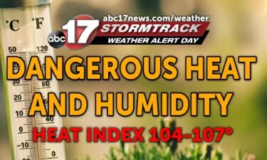
UPDATE: Wednesday Evening Update: This blog has an updated forecast video and heat index tracker through Friday. BLOG: The ABC 17 Stormtrack Weather Team has issued a Weather Alert Day through Thursday as dangerous heat is expected to impact much of the country, including Mid-Missouri. Heat index values could be in excess of 105 degrees,
Continue Reading
TODAY: This morning is another warm and humid start. Temperatures on Wednesday will climb back to near 100 degrees. Expect feels like temperatures in the triple digits. After some light shower activity this morning, isolated storms are possible this afternoon. These will only bring mild relief to some. TONIGHT: Late tonight, showers and storms become
Continue Reading
TODAY: Warm and muggy is one way to describe Monday morning. Temperatures will climb from the low 70s, into the mid-90s by Monday afternoon. Dewpoints in the low 70s will make it feel like low triple digit heat, so we’ve issued a Weather Alert Day for dangerous heat. Be wary of heat related illnesses today.
Continue Reading
TONIGHT: Muggy and hot, increasing clouds. Lows in the upper 70s. TOMORROW: Partly cloudy, hot, and humid with highs near 100. Heat index between 105-107. Scattered storms possible by late afternoon or evening north of I-70. EXTENDED: The Weather Alert Day has been extended through Thursday night with another day of high temperatures in the
Continue Reading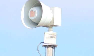
The commission approved more than $172,000 to spend on the project during its regular meeting Tuesday, according to commission documents.
Continue Reading Today: Temperatures will top out into the triple digits this afternoon as the heat index could reach 107 degrees in some areas across Central Missouri. Winds remain out of the southwest at 5-10 mph with mostly sunny sky conditions. Tonight: Temperatures slowly cool to the upper 70’s for tonight’s overnight low with mostly clear skies.
Continue Reading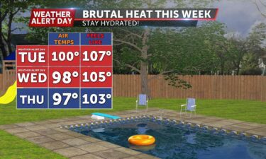
TODAY: Temperatures soar to triple digits this afternoon with the heat index breaching 105 degrees for some. Mostly clear with wind gusts up to 20 mph today. TOMORROW: Highs again reach near triple digits with the heat index soaring to near 105. EXTENDED: With all the heat and humidity building up across the region we
Continue Reading 4Th of July: Skies look to remain mostly clear tonight allowing for great firework viewing conditions. High humidity will make the actual temperatures feel warmer. Tonight’s lows cool to the upper 70’s keeping us well above average. Tomorrow: Temperatures will soar to triple digits tomorrow with the heat index expected to surpass 105 degrees in
Continue Reading
TONIGHT: Mostly clear and muggy with lows in the upper 70s. TOMORROW: Hot and humid with highs in the upper 90s. Heat index between 104-107. EXTENDED: Intense heat continues most of this week with a heat index topping 105 tomorrow and getting close again on Wednesday. There’s a chance we may need to extend the WAD into Thursday, but
Continue Reading Tonight: A few isolated storms will push through Central Missouri bringing brief downpours and lightning. These will begin to dissipate into the overnight hours leading for a great opportunity to watch some fireworks. Overnight lows cool to the lower 70’s. 4TH of July: Temperatures heat up quickly with increased humidity leading to dangerously high temperatures
Continue Reading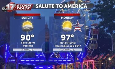
SUNDAY: Isolated showers possible before noon. Mostly cloudy with highs nearing 90 degrees. Another round of scattered storms is possible near dinnertime but will clear up in time for fireworks tonight. 4TH OF JULY: Dry and hot with highs jumping to the mid-90s. High humidity will send the heat index to 105+ degrees. Skies stay
Continue Reading Tonight: Scattered showers and storms will continue to move through Central Missouri thanks to a stalled cold front hovering over the I-70 corridor. The main threat will be lightning with some heavy isolated downpours as the overnight lows bottom out around 70 degrees. Tomorrow: Scattered showers and storms will continue to form along the stalled
Continue Reading