
Energy companies share ways customers can save money and energy
Boone Electric Cooperative is asking members to conserve energy Thursday and Friday due to high temperatures.
Continue Reading Boone Electric Cooperative is asking members to conserve energy Thursday and Friday due to high temperatures.
Continue Reading
TONIGHT: Storms developing along a cold front north of I-70. Some storms could be strong to severe after sunset through about midnight with damaging winds and hail. Lows in the mid-70s. TOMORROW: Hot and humid with highs in the mid-90s and heat indices in the low 100s. Storms move back in after sunset. EXTENDED: A
Continue Reading
TODAY: Hot and breezy with highs in the mid-90s. Heat indices from 98-100 degrees. Storms are likely near sundown, particularly north of I-70. TOMORROW: A hot summer day with highs in the mid to low 90s. Another round of late evening storms is possible. EXTENDED: A slow-moving cold front to our north triggered storms across
Continue Reading
The ABC 17 Stormtrack Weather Team has issued a Weather Alert Day through Tuesday as dangerous heat is expected to plague the area. Heat index values could be in excess of 105 degrees, making it tough to complete any work or exercise outdoors. SETUP: Upper level high pressure begins to force the jet stream north,
Continue Reading
TONIGHT: Mostly clear and muggy with lows in the upper 70s. TOMORROW: Breezy and hot with highs in the mid-90s. Heat index between 98-100. Storms possible around sunset, especially north of I-70. EXTENDED: We’ll fall once again into the upper 70s tonight with gusty south winds expected Wednesday. Highs on Wednesday reach the mid-90s with a heat
Continue Reading
Temperatures across the Midwest have been well above average this past week with the heat index surpassing 100 degrees the past few days with one more day expected. Trends are currently highlighting an extended period of warmer temperatures throughout the next 10 days or more. With such high temperatures you might know how to keep
Continue Reading Today: Highs will continue to the upper 90’s as the heat index will surpass the 100 degree mark once again possibly reaching 103 degrees in some areas. Skies remain sunny as winds continue to pull out of the southwest at 10-5 mph. Tonight: Temperatures remain well above average as the overnight lows fall to the
Continue Reading
TODAY: Tuesday brings more sunshine than Monday. Skies are starting clear, and will stay that way through the day. This will allow for temperatures to warm quickly today, perhaps a little warmer than yesterday. Despite temperatures being similar to Monday, dewpoints will be a tick lower, lending to a slightly cooler feeling day. Still, with
Continue Reading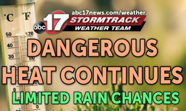
TONIGHT: Mostly clear and stuffy with temperatures remaining in the upper 70s. TOMORROW: Mostly sunny and breezy with highs in the mid-upper 90s. Heat index values between 102-106. EXTENDED: The Weather Alert Day will continue into tomorrow with heat indices between 102-106. We won’t have much relief other than a strong southwest breeze, but it’s hard to
Continue Reading TODAY: Temperatures start incredibly warm this morning; in the upper 70s, with dewpoints in the 70s. This warm and muggy start will give us a head start on a run at triple digits this afternoon. Midday cloud cover, and a spot shower or two may keep temperatures from breaking 100, but upper 90s are likely.
Continue Reading Tonight: Light isolated showers will begin to dissipate late tonight leading to partly cloudy overnight conditions. The overnight lows bottom out into the mid to upper 70’s. Tomorrow: Scattered early morning showers and storms will pull through Central Missouri before exiting by noon. Temperatures will quickly begin to rise by the early afternoon hours to
Continue Reading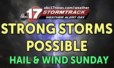
The ABC 17 Stormtrack Weather Team has issued a Weather Alert Day for the potential of strong storms on Sunday. A complex of storms moving out of Nebraska will dive into Mid-Missouri early Sunday afternoon and bring the possibility of damaging winds and hail. SETUP: Hot and humid conditions across the region have ushered in
Continue Reading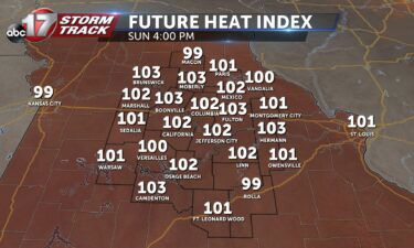
TODAY: An isolated shower or two possible early with lingering cloud cover by the afternoon. Highs reach the mid-90s and increasing moisture will push the heat index to the triple digits. TOMORROW: A lack of clouds opens Mid-MO up to even more intense heat; highs reach the upper 90s and heat indices will likely breach
Continue Reading Tonight: Scattered showers and storms will move into northwestern parts of Central Missouri leading to increased chances to see strong to severe storms north of highway 70 tonight from 8 PM- 2AM. Strong winds and damaging hail will be the main threats tonight. The overnight lows bottoms out into the lower 70’s. Tomorrow: Early morning
Continue Reading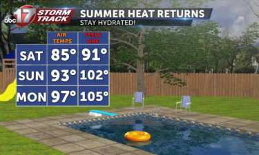
TODAY: Patchy fog early; temperatures rise to the mid to upper 80s under mostly sunny skies. Storms are possible in the evening, particularly to the north and west. TOMORROW: Summer heat arrives with highs in the low 90s and heat indices approaching triple digits. EXTENDED: Storms on Saturday evening could potentially form into an isolated
Continue Reading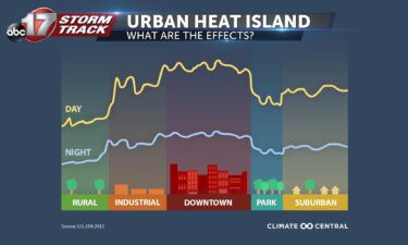
With a cooler start to June, conditions are soon expected to change. A high-pressure ridge is expected to build overhead Central Missouri next week leading to dryer and well above average temperatures. On average, Columbia typically sees 10 days a year where the heat index surpasses 100 degrees. Columbia Missouri is ranked as the fourth
Continue Reading
TONIGHT: Partly cloudy with isolated storms diminishing with sunset. Patchy fog developing overnight. Lows in the low 60s. TOMORROW: Mostly sunny and warmer with highs in the low to mid-80s. A few storms possible across northern portions of the area by evening. EXTENDED: We’ll see isolated showers and a few storms possible through sunset, with
Continue Reading Today: Temperatures will top out just below 80 degrees before afternoon isolated storms roll through Central Missouri. The majority of Mid-Missouri looks to stay dry, but some areas will see small celled storms bring the potential for brief heavy downpours and smaller hail. Tonight: Skies remain partly cloudy with overnight lows hitting the average mark
Continue Reading
TODAY: Showers and storms will continue throughout Friday morning, with the most widespread activity expected in the morning. We will likely see rain on radar this afternoon, but it will be very isolated, with much more dry time, especially along and north of I-70. Some sunshine may peak through the clouds through the late morning
Continue Reading
TONIGHT: Increasing clouds with rain moving in late. Lows in the upper 50s to low 60s. TOMORROW: Mostly cloudy with scattered showers and storms. Highs in the mid-upper 70s. EXTENDED: It’s been a gorgeous Thursday with lower humidity and plenty of sunshine, but clouds start to thicken tonight ahead of our next complex of storms
Continue Reading