
Weather Alert Day: Severe threat winding down this afternoon
Storms expected to spread into Mid-Missouri by early afternoon.
Continue Reading Storms expected to spread into Mid-Missouri by early afternoon.
Continue Reading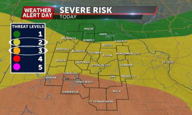
TODAY: A Weather Alert Day is in effect for potentially severe storms Sunday – read more details here. A cold front arrives midmorning, bringing thunderstorms into Chariton, Saline, and Macon counties from the northwest. Initially heavy downpours will be the main threat before storms possibly strengthen as they head south. Those south of I-70 will
Continue Reading
Officials from departments such as MODOT, are reminding drivers on how to stay prepared for driving severe weather, as Missouri is expected to see significant storms.
Continue Reading
TONIGHT: Isolated pop up storms are expected again this evening, without severe potential. Still, lightning will be a concern with these. Most thunderstorm activity will be confined to an area south of I-70, with a focus towards I-44. Otherwise, most stay dry overnight, with temperatures dropping into the low 60s by sunrise. TOMORROW: Speaking of
Continue Reading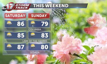
TODAY: Storms exit early and skies clear by the afternoon. Highs in the mid-80s. An isolated storm is possible late afternoon. TOMORROW: Showers and storms in the morning, some potentially severe. Highs in the upper 70s. EXTENDED: Saturday is largely dry with the exception of a pop-up storm or two in the heat of the
Continue Reading
UPDATE: 4PM FRIDAY Storms are expected to fire up along and east of Highway 63 after 6:00 p.m., and will maintain intensity through about 10:00 or 11:00 p.m. Storms will have the capability of producing large hail and damaging winds, along with heavy rain. Updated below are the severe risk map and latest Futuretrack with
Continue Reading
TONIGHT: Scattered showers and storms, some could be strong with damaging winds east of Highway 63 before midnight. Lows in the low to mid-60s. TOMORROW: Storms exit early, becoming mostly sunny. Highs in the mid-upper 80s. EXTENDED: Clusters of storms with the potential of damaging winds up to 60 mph and small hail (pea to
Continue Reading
Today: Temperatures will continue to rise before this afternoons approaching storms up to 90 degrees. After four this afternoon, storms will begin to develop across Central Missouri beginning scattered, then transitioning to more widespread by this evening. The main risk with these storms will be winds up to 60 MPH and hail up to 1″
Continue Reading
TODAY: A Weather Alert Day has been issued for Friday, as severe storms are expected for some this afternoon. The heat and humidity has been allowed to build for the last week, but a cold front moves through this afternoon to bring an end to that. The front is to our west this morning and
Continue Reading
April through July are the peak months for hail in Missouri according to the National Weather Center.
Continue Reading
TONIGHT: Partly cloudy with lows in the upper 60s. TOMORROW: Partly to mostly cloudy and hot with highs in the upper 80s. Storms developing by late afternoon into early evening could become severe with damaging winds and hail. A Weather Alert Day is in effect through late Friday night. EXTENDED: Near-record heat will come to
Continue Reading
TODAY: Another copy and paste forecast is in store today, with more hot and humid weather expected Thursday. Highs will reach low 90s again with sunny skies and a consistent southerly breeze. It may feel more like upper 90s with the added humidity. TONIGHT: Despite clouds to our west inching closer, most will stay mostly
Continue Reading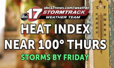
TONIGHT: Mostly clear, mild, and muggy with lows in the lower 70s. TOMORROW: Mostly sunny and hot with highs in the low to mid-90s. Heat index in the upper 90s. EXTENDED: Another muggy evening is in store with lows in the lower 70s. Tomorrow’s record of 93 degrees will also be in jeopardy with a forecast
Continue Reading Today: Temperatures continue to rise to just above 90 degrees with the heat index topping out into the upper ’90s. Winds remain out of the south at 4-8 mph. Tonight: Skies remain partly cloudy with winds remaining out of the south at 4-8 mph. The overnight low cools to around 70 degrees. Extended: Thursday we
Continue Reading
TODAY: Wednesday starts warm much like Tuesday. With temperatures starting in the low 70s and upper 60s, we have another setup for a summer-like day. Expect some cloud cover in our skies today, but not enough to cool us off. We likely climb to around 92 under partly cloudy skies. Dew points near 70 will
Continue Reading
TONIGHT: Partly cloudy and muggy with lows in the lower 70s. TOMORROW: Partly to mostly sunny with highs in the lower 90s. Heat index values between 98-100. EXTENDED: It’s muggy and warm again tonight with a spot shower possible around sunset, but not expecting much more than that with the bulk of today’s storm action yet again across
Continue Reading
TODAY: Temperatures this morning are about 5 to 10 degrees warmer than they were 24 hours ago. This will give today a very good chance of outpacing yesterdays temperatures by a few degrees. With a largely similar forecast, temperatures will climb faster and farther than Monday. Expect highs in the low to mid 90s Tuesday
Continue Reading
TONIGHT: Mostly clear and breezy with lows in the upper 60s to around 70. Wind gusts up to 25 mph. TOMORROW: Mostly sunny and hot. Highs in the low 90s with a heat index near 100 degrees. EXTENDED: We’ll continue our streak of near record neat through Thursday as forecast highs reach the low 90s. This isn’t
Continue Reading Today: Temperatures soar to near 90 degrees with the heat index around the mid-90s. Skies remain mostly clear with gusts of up to 32 mph possible. Tonight: The overnight low bottoms out into the mid-60s putting Central Missouri nearly 15 degrees above normal for the start of May. Skies remain mostly clear with winds remaining
Continue Reading
TODAY: After some clouds this morning, more overall sunshine and clear skies is expected Monday. This and more south wind will jump temperatures nearly another 10 degrees over yesterday. Expect possibly record breaking heat today, with highs climbing into the low 90s. Today will be hot, but also breezy. Winds will be sustained out of
Continue Reading