Comparing winter precipitation types and their threats
You’ll likely hear about many different types of winter precipitation such as freezing rain, sleet and snow, but what are these exactly and what risks do they pose?
Continue Reading You’ll likely hear about many different types of winter precipitation such as freezing rain, sleet and snow, but what are these exactly and what risks do they pose?
Continue Reading
We’ve all heard thunder and seen lightning during thunderstorms that we associate with warmer months, but have you ever heard thunder during a snowstorm? If so, you’ve encountered a rare event. The last recorded occurrence was captured by the National Weather Service’s St. Louis Office when a lightning flash was documented as snow fell in
Continue Reading
The salt you use on your sidewalk each winter is, at its base, the same as what the Missouri Department of Transportation uses to clear our roads. With that said, their methods can be a bit more complex.
Continue Reading
Decades of evidence proves that the Earth is warming, but to what extent and what does that mean for Mid-Missouri winters?
Continue Reading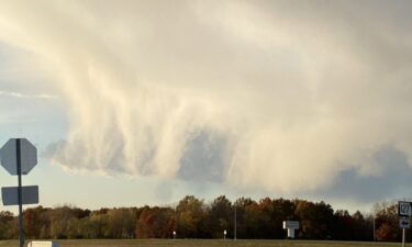
A cold front worked through Mid-Missouri last night, bringing gusty winds and temperatures back into the low 50s this afternoon. We were expecting a cool down, but how did some areas end up with what looked like snow showers when we were above freezing? It’s an interesting phenomenon that can happen when there are varying
Continue Reading
Coastal communities dealt with flood waters over the weekend that have a complicated origin story. One of the underlying causes of this weekend’s flooding is the ocean’s tide. The highest of the year — the tide behind the rising water is often called a king tide. It comes when the position of the earth, moon,
Continue Reading
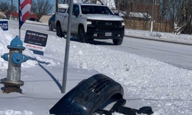
Temperature swings can be uncomfortable, but they can also be hard on roads and highways around mid-Missouri. That is, if the swing spans across the freezing mark. “The more freeze/thaw cycles you have, the more likely you are to see potholes,” says MODOT District Engineer, Jason Schafer. Repetitive freezing and thawing highlights pre-existing imperfections in
Continue Reading
Many of us are familiar with the northern lights, the green glow in the night sky that we typically don’t see around here. The scientific name for this phenomena is the aurora borealis. When solar energy reaches earth’s magnetic field, it is channeled to the poles. When this energy collides with gasses in our atmosphere,
Continue Reading
We’ve been talking about frost in the forecast all week, but what is the science behind the forecast? High pressure sliding in out of the north tonight might just provide the right set up to leave frost across portions of the area early Wednesday morning. This high will provide some of us with two things;
Continue Reading
Those who don’t enjoy winter should’ve enjoyed Monday’s cold and rainy weather. After all, at least it’s not snow, right? The same can’t be said for those just down the road in Kansas City. Flakes could be seen falling across the city, including on our camera at Legends Field. The temperature reading around this time
Continue Reading
This week’s storms were a reminder, for one local EMA Director, of how vulnerable their residents are to severe weather. “We are physically a larger county, and our population is spread out.” Samantha Henley, Director of Emergency Management for Camden County, says the rural nature of her county is just one of the reasons residents
Continue Reading
You’ve probably already noticed that leaves in our area are changing quickly. It’s beautiful, and it has been for the past week. Leaves are near their peak color here in mid-Missouri, which may have you wondering what it is that creates all this beauty. As we get further into autumn, days get shorter and night get
Continue Reading
While we have our own storm system to talk about close to home, we’re also tracking a nor’easter just off the east coast. Named for the harsh northeast winds they often bring to the coast, nor’easter’s can be costly; bringing wind and flood damage with them. The storm we are talking about tonight has already
Continue Reading
Some Pettis County residents voiced concerns over the timeliness of tornado sirens during Sunday’s storms. The ABC 17 StormTrack Weather Team was tracking the storm that spawned two EF-0 Tornadoes on the outskirts of Sedalia on Sunday. This particular storm developed rotation rather quickly. Shortly after the storm started showing signs of rotation, the National
Continue Reading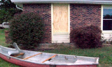
Sunday’s storms caused damage across the state of Missouri, with the most impactful damage in mid-Missouri coming just outside of Sedalia.
Continue Reading
Watch live coverage of storms in the player below. SUNDAY AFTERNOON UPDATE: Storms are starting to fire up along the cold front in western Missouri, and will quickly become severe as they move east into Mid-Missouri. A Tornado Watch has been issued for the entire area until 10PM. Watch a 3 p.m. update from the
Continue Reading
This time last year, the Storm Track Weather Team was talking about the first snow of the season. Now, we’re discussing severe storms. While spring may be our traditional severe weather season, favorable set ups for severe weather can also be found here in autumn. The Jetstream plays a large role in this. In fall,
Continue Reading
After a hot weekend in Mid-Missouri, we’ve started off the week on a wet note with a strong low pressure working its way through the Plains and Midwest over the last 24 hours. We’ll continue to be cool overnight in its wake, as lows Monday night drop into the low 50s. Clouds clear out and
Continue Reading
Welcome to Autumn! Mother Nature’s feeling festive this year and brought us some classic fall-like weather to start the season. Cool mornings and mild afternoons have us looking ahead to what’s in store for the Autumn season. WHAT IS AUTUMN Sunlight gives us weather but the tilt of the earth gives us the seasons. That
Continue Reading
If you’ve been patiently awaiting fall-like temperatures to catch up with the calendar, we’re finally getting a break from the heat after a cold front moves through tonight. Temperatures across the mountain west and upper Plains have dipped into the 60s for highs on Monday, a sharp contrast of what we have seen the last
Continue Reading