Interstate 70 bridge near Rocheport reopens
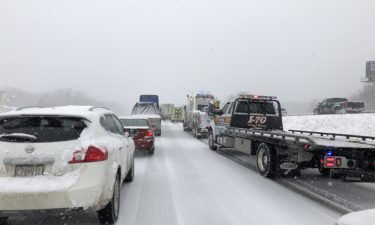
Parts of Interstate 70 were closed to drivers west of Columbia on Wednesday afternoon.
Continue Reading Parts of Interstate 70 were closed to drivers west of Columbia on Wednesday afternoon.
Continue Reading
Mid-Missouri roads became covered on Wednesday morning as heavy snow began to fall throughout the area.
Continue Reading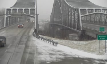
The Missouri Department of Transportation Central District says it is looking into buying more salt after using more than half of its supply this winter.
Continue Reading
WEDNESDAY: While thing may be quiet upon waking up, it doesn’t look to last long. Snow will push back into the area toward the mid to late morning hours and stays with us all day. New snow accumulations will be in the neighborhood of 3-7”. To see where the snow is at throughout the day
Continue Reading
Jefferson City Public Works and MoDOT Central District officials are urging drivers to be cautious if they are headed to the Chiefs’ Super Bowl victory parade Wednesday
Continue Reading
COLUMBIA, Mo. (KMIZ) Columbia Public Schools canceled classes Wednesday ahead of expected snow. The ABC 17 Stormtrack Weather Team issued a Weather Alert Day for the expected winter weather. District spokeswoman Michele Baumstark cited the impending weather and timing of the snow in an email sent after 5 p.m. “The safety of our students and
Continue Reading
The Missouri Department of Transportation is keeping an eye on the weather as a wintry mix starts to fall on Mid-Missouri with more in the forecast.
Continue Reading
Columbia Public Works and Boone County Road and Bridge were working Tuesday morning on plans for pretreating and removing snow from roads.
Continue Reading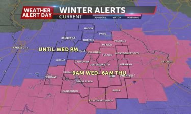
*A Weather Alert Day is in effect through Wednesday night for wintry weather* TONIGHT: Mostly cloudy with scattered freezing rain and sleet. Isolated slick spots are possible. Precipitation ends before midnight. Lows in the upper 20s. WEDNESDAY: The last round of precipitation arrives as snow by mid-morning, lasting all day. Temperatures remain steady around 30
Continue Reading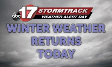
TUESDAY: Light rain chances will start to ramp up into the early afternoon. As they do, a wintry mix will begin to work in. A light glaze of ice and sleet could lead to elevated surfaces becoming slick by this afternoon and evening commute. Temperatures will start out in the middle 30s and will trim
Continue Reading
Here's #KansasCity erupting in celebration, as detected by our radar! 🎉🎇🎆🏈 pic.twitter.com/IlfG82gxl6— NWS Kansas City (@NWSKansasCity) February 3, 2020 The National Weather Service in Kansas City posted a radar loop of a brief burst in their signal around the time the Chiefs were named Super Bowl champions. This can be a bit tough to see
Continue Reading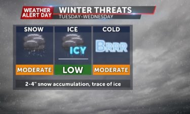
*A Weather Alert Day is in effect from Tuesday through Wednesday night* TONIGHT: Mostly cloudy, showers possible south of Highway 54. Lows in the mid-30s. TUESDAY: Mostly cloudy with showers by afternoon, changing over to mainly sleet as temperatures dip below freezing. Sleet eventually changes to snow briefly on Tuesday night. Highs near 35, but
Continue Reading
MONDAY: Quiet, warm weather sticks around one last day as temperatures get into the low to mid 60s despite cloud cover increasing. Rain chances are held to the evening. TONIGHT: Scattered showers push in as a front slides through. Temperatures will come back to reality overnight with lows fall into the middle 30s. EXTENDED: That’s
Continue Reading
TONIGHT: Partly cloudy to mostly clear. Mild with lows in the upper 30s to low 40s. MONDAY: Increasing clouds but still nice through most of the day. Highs in the low 60s. EXTENDED: A slow moving cold front will approach the area on Monday from the north. This slowly slides across the region over the
Continue Reading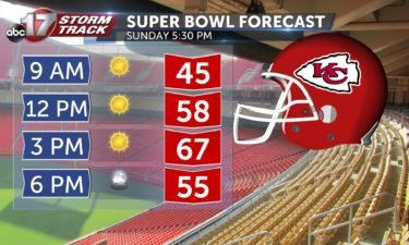
SUPER BOWL SUNDAY: Warm and sunny with highs in the mid to upper 60’s. SUNDAY NIGHT: Increasing cloud cover but staying warm. Lows in the low 40’s. EXTENDED: Monday will continue to be warm to start off the workweek with highs in the low 60’s but will be mostly cloudy. The clouds will linger but
Continue Reading
TONIGHT: Mostly clear with a low in the upper 30’s. SUPERBOWL SUNDAY: We don’t need to travel to Miami to experience some warmer temperatures for the game! Tomorrow temperatures will rise into the mid to upper 60s by kickoff. We’ll be seeing lots of sunshine throughout the day, and we may even break the record high temperature.
Continue Reading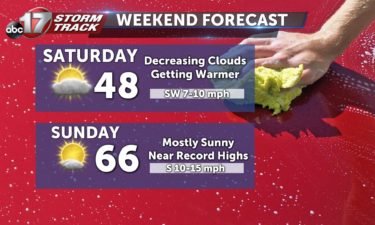
SATURDAY: We will start the day off partly cloudy but will see those clouds move out and leave us mostly sunny by the afternoon. Highs are in the upper 40’s and near 50 degrees. SATURDAY NIGHT: Mostly clear with a low in the upper 30’s. SUPERBOWL SUNDAY: We will be feeling like Miami here in
Continue Reading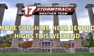
TONIGHT: Mostly cloudy with a few sprinkles or flurries. Lows in the low 30s. TOMORROW: Patchy fog with clouds gradually decreasing. Highs reach the mid-upper 40s. EXTENDED: Warm winds and southwest upper flow will bring in much warmer temperatures for Sunday, and clear out the clouds for the day. Highs will reach the mid-60s, and
Continue Reading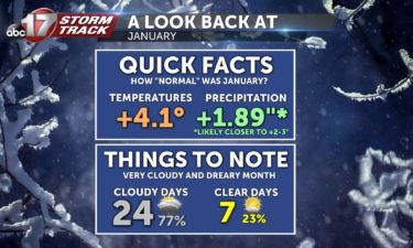
We were off to such a good start… The end of 2019 and start of 2020 was one of the warmest stretches of weather to start the winter season ever in Mid-Missouri. This was coupled with plenty of sunshine, with many of us asking if winter was going to make a return after its quick
Continue Reading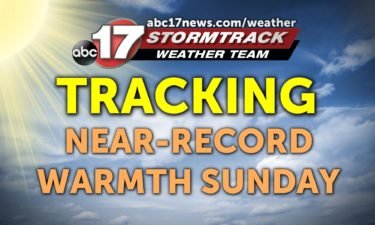
THIS AFTERNOON: Clouds continue to hold strong but peeks of sunshine are expected. Temperatures will remain in the low 40s. TONIGHT: Another chilly evening is expected. Temperatures fall into the low 30s. EXTENDED: Saturday, clouds are expected to clear out by late in the morning leading to partly cloudy skies into the afternoon. Temperatures jump into the
Continue Reading