
Weather

Tracking gorgeous weather on Election Day
TUESDAY: Absolutely gorgeous weather will be the story going forward this week. Temperatures will reach the upper 60’s and low 70’s today with plenty of sunshine. Try to get out and enjoy it! TONIGHT: Mostly clear skies will linger overnight with lows falling into the upper 40’s and low 50’s. EXTENDED: We’re tracking a weak
Continue Reading
Defining the “Indian summer” & stats for November warm spells
Defining “Indian summer” The phrase “Indian summer” is likely a bit dated. Especially since we know Columbus didn’t land in India in 1492. The expression is defined in the weather community as a period of abnormally warm weather in Autumn or early winter. It’s most commonly used following an areas first killing frost. Temperatures across
Continue Reading
Tracking a mild Election Day, beautiful weather this week
TONIGHT: Mostly clear and cool. Lows in the low 40s. TOMORROW: Mostly sunny and nice with highs in the upper 60s to around 70. EXTENDED: We’re in for a gorgeous week with just a few clouds thrown into the mix Wednesday night and Thursday as a disturbance slides by to our north. The jet stream
Continue Reading
Indian Summer pattern taking over this week
TONIGHT: We’ll hold onto clear skies into this evening. Expected temperatures to fall through the 50s and upper 40s by 10pm. We’ll be waking up to the low 40s out the door in the morning. ELECTION DAY: With a cool start tomorrow, you’ll probably want the jacket, especially if you have to stand outside at your
Continue Reading
Tracking a week of tranquil weather
MONDAY: More sunshine looks to be in store this afternoon! Highs will work into the upper 50’s and low 60’s with a southwesterly breeze helping out matters. TONIGHT: Mostly clear night in store, but won’t be quite a chilly to start off tomorrow. Overnight lows will fall to near 40. EXTENDED: It will be slightly
Continue Reading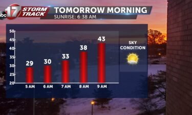
Tracking a chilly start to the workweek
TONIGHT: We are tracking cool conditions overnight tonight, so if you still have some tomato plants, you may want to cover them as frost is a possibility. Lows will fall into upper 20s and lower 30s. TOMORROW: If you’re still looking for a taste of fall, Mother Nature has some good news for you. Temperatures will
Continue Reading
Tracking a breezy start to November
TODAY: A cold front that passed through last night will push temperatures into the upper 40s for most of the day. Some clouds may try to pop up throughout the day but conditions will stay favorable. Breezes will continue with wind gusts as high as 30 mph. MONDAY: Temperatures will rebound into the beginning of the workweek.
Continue Reading
Tracking less than spooky Halloween conditions
TONIGHT: While conditions are comfortable for trick or treaters tonight, a cold front will be moving into mid-Missouri as we approach Sunday morning. Lows will fall into the upper 30s. TOMORROW: This cold front will drop high temperatures into the upper 40s to close out the weekend. Low moisture in the area means no storms
Continue Reading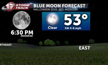
Rare Blue Moon on Halloween arrives Saturday evening
It was a very active week across mid-Missouri, but things are expected to quiet down as we head into Halloween. It will make a perfect evening to view the Blue Moon as it rises in the east-northeast sky around 6:30pm. You can get more info on the history of Blue Moons on Halloween at this
Continue Reading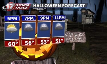
Warm and windy conditions to start the weekend
TODAY: We’re in luck today as those spooky, cloudy skies we saw for much of this past week will hold off. Temperatures will start off in the 40s throughout the morning and reach the 50s by noon. These will continue to rise into the later afternoon with highs in the low 60s. By this evening,
Continue Reading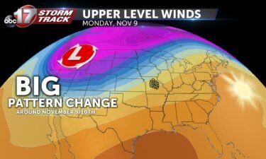
October’s wild ride of weather, and what’s ahead for November
October’s Wild Ride! It’s typical for fall to bring lots of up and down temperature swings. October 2020 was no expection for mid-Missouri. Temperatures as a whole were pretty cool on average. Even with tomorrow’s trend towards warmer weather to close out the month, we’ll likely see temperatures run about 1.6º below normal. Precipitation continues
Continue Reading
Tracking big temperature swings this weekend
TONIGHT: Mostly clear and chilly with lows in the upper 30s to around 40. TOMORROW: Breezy and warm with south wind gusts between 20-30 mph. Mostly sunny with highs in the low to mid-60s. EXTENDED: After a warm and windy Halloween, a cold front slides through Mid-Missouri Saturday night, bringing a wind shift and much
Continue Reading
Tracking some much-deserved sunshine
FRIDAY: After a frosty start, plenty of sunshine will help us close out the week in style. Temperatures will make it back into the upper 50’s-easily the warmest they’ve been all week. TONIGHT: Those mostly clear skies stay overhead, but with winds staying out of a southerly direction, won’t be as cold. Overnight lows will
Continue Reading
Tracking a cold start to Friday followed by beautiful Halloween
TONIGHT: Becoming mostly clear with diminishing winds. Lows in the low 30s. Patchy frost possible. TOMORROW: Mostly sunny and warmer with highs in the mid-50s. EXTENDED: We’ll start the weekend off on a gorgeous note with plenty of sunshine on Saturday and highs in the low 60s. It’s quiet and clear for any outdoor Halloween
Continue Reading
Cold night ahead, Warming through the weekend
THURSDAY: Showers are continuing to work through the area. You’ll want to keep the umbrella handy through this morning, but should be able to set it down finally this afternoon. A breeze out of the north will keep us from getting back to 50 today, even with a little late day sunshine. TONIGHT: With clear
Continue Reading
Speedy Hurricane Zeta breaks several hurricane records Wednesday evening
Records Broken By Zeta #Zeta is the record-setting 5th named storm (NS) to make landfall in Louisiana in 2020, eclipsing the old record of 4 Louisiana landfalling NS set in 2002. 2020 LA NS landfalls to date: Cristobal, Marco, Laura, Delta, #Zeta 2002 LA NS landfalls: Bertha, Hanna, Isidore, Lili pic.twitter.com/qblG00HQl0— Philip Klotzbach (@philklotzbach) October
Continue Reading
Tracking showers overnight into Thursday
TONIGHT: Cloudy with rain likely overnight into Thursday. Lows in the upper 30s to around 40. TOMORROW: Showers likely early, tapering off by late afternoon. Highs in the upper 40s to around 50. Rainfall totals between 0.5″ and 1.5″. EXTENDED: Showers exit on Thursday evening, allowing much cooler air to filter in from the north.
Continue Reading
Tracking another round of rain this evening
THIS AFTERNOON: It’s a gloomy overcast start to the afternoon. Steady rainfall is continuing to work northward. Have the umbrella ready for the evening commute, especially if you’re in and south of Jefferson City. TONIGHT: That steady rain will carry us through tonight. Lows will fall into the upper 30’s. EXTENDED: Rain will start to
Continue Reading
Mother Nature brings extreme weather to close out October
MID-MISSOURI’S FIRST SNOW Light snow fell across parts of mid-Missouri yesterday. The main rain/snow line as from Mexico through Sedalia. The official total at Columbia Regional Airport was 0.4″– a combination of snow and sleet. Some reports near Columbia were as high as 1″, especially on the north side of town. 1" of snow measured
Continue Reading