
Highway patrol: Slow down and look ahead in slick conditions
Missouri State Highway Patrol troopers were sent to 59 crashes Wednesday — more than in any of the four previous winter weather events this year.
Continue Reading Missouri State Highway Patrol troopers were sent to 59 crashes Wednesday — more than in any of the four previous winter weather events this year.
Continue Reading
This week, for me personally, has been a sniffly, sneezy and eye-burning fiasco. Okay, that’s perhaps a little dramatic– but it seemed to be affecting others in our newsroom too. While we’re definitely in the height of cold and flu season, we’re actually probably seeing that compounded by an early start to allergy season too.
Continue Reading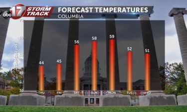
TONIGHT: Few flurries early, clearing up overnight. Lows falling into the upper teens to low 20s. THURSDAY: Increasing clouds, chance of sprinkles or flurries late into the day through evening. Highs in the mid-40s. EXTENDED: A clipper system will bring a chance for precipitation through early Friday, mainly in the form of scattered light rain
Continue Reading
THIS AFTERNOON: A few flurries or sprinkles are possible this afternoon. No impacts are expected. Temperatures will remain chilly. TONIGHT: With those clouds having left us, overnight lows will fall to near 20 degrees. Wind chills will be in the teens tomorrow morning, so you’ll want the heavy coat again. EXTENDED: Sunshine will pop again tomorrow morning, with
Continue Reading
WEDNESDAY: Snow will slowly exit the area later this morning. Here’s a way to check the radar before heading out in the morning. It will be chilly throughout the day with afternoon highs only managing the middle 30s. A steady northwest wind will drop feels like temperatures into the low to mid 20s. We’ll manage
Continue Reading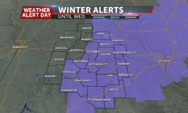
Synopsis: The ABC 17 Stormtrack Weather team has issued a Weather Alert Day into Wednesday morning. Light snow accumulation is expected overnight, especially for locations east of Highway 63. A Winter Weather Advisory is in effect for parts of Mid-Missouri through Wednesday morning. Impacts/Timing: Snow is expected to taper off by mid-morning Wednesday, and temperatures
Continue Reading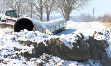
Flooding in the Spring of 2019 caused hundreds of thousands of dollars in damage and forced some people to evacuate their homes.
Continue Reading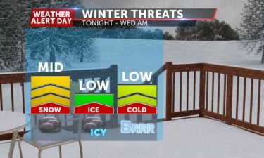
TONIGHT: Mostly cloudy with light snow showers. Most areas end up with a trace to 2″, with the highest amounts north of I-70. Lows in the upper 20s. WEDNESDAY: Snow showers taper off from west to east in the morning, leaving us with cloudy skies during the day. Highs in the low 30s. EXTENDED: The
Continue Reading
The amount of water being released into the Missouri River from Gavins Point Dam will be increased again to free up more space in the reservoirs upstream before spring.
Continue Reading
Officials are considering a new protocol to sound sirens throughout a severe weather event.
Continue Reading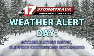
TUESDAY: Light rain will linger into the early parts of the day, becoming a bit steadier this afternoon. We may try to mix in a few snowflakes throughout the day, but accumulations don’t look to be a problem until this evening. Highs top out in the upper 30s. TONIGHT: As that rain/snow mix transitions over
Continue Reading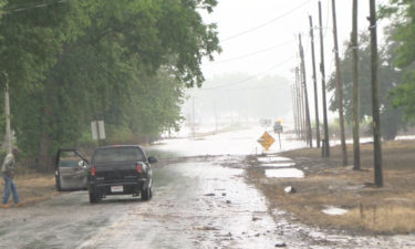
The spring outlook for 2020 is showing flooding can be expected again. Some experts even hint that it could be worse than last year.
Continue ReadingAmeren Missouri installed an underground smart grid system in downtown Jefferson City that aims to reduce the length of power outages.
Continue Reading
TONIGHT: Mostly cloudy with scattered showers. Lows in the mid-30s. TUESDAY: Scattered showers and chilly. Highs in the upper 30s. Rain changes to snow by early evening. Most areas will see about an inch or less of accumulation. EXTENDED: Snow showers taper off from west to east early Wednesday morning, leaving a coating of snow
Continue Reading
THIS AFTERNOON: Rain showers will continue on and off through about 5pm before shutting off for the evening. Northerly winds will filter in colder air through sundown. TONIGHT: Sprinkles and showers are likely, especially north of I-70 overnight. Snow could be possible near Macon, but we’re not expecting impacts. EXTENDED: Another area of low pressure will fill
Continue Reading
MONDAY: Rain has pushed in this morning and will stick around for much of the day. Highs will be in the middle 40s today with that umbrella getting a workout. TONIGHT: Rain chances will thin a bit in coverage, but stick around. We’ll try to mix in a few snowflakes closer toward daybreak with lows
Continue Reading
TONIGHT: Rain builds into mid-Missouri overnight. The rain could be heavy at times and there could be a few rumbles of thunder– especially south of I-70. A flood watch is in effect for counties along and south of HWY 50. Ponding on roadways is possible. Remember to never try to cross a flooded roadway! No
Continue Reading
SUNDAY: Most of us are starting the day off dry and mostly cloudy but rain will move in towards the evening hours. Since we will see some sun through the clouds before the rain, we will be able to get into the middle 50’s for our high. SUNDAY NIGHT: Rain intensity starts to pick up
Continue Reading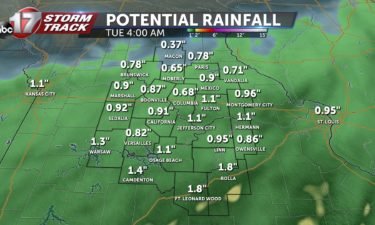
TONIGHT: Clouds begin increasing as we move through the evening into the overnight hours. Lows will be in the mid-30s. TOMORROW: Temperatures will be similar to what we saw today, however cloud coverage will continue ahead of rain showers. Light rain will move in from the south and move north throughout the afternoon. A FLOOD
Continue Reading
SATURDAY: Clear skies and warmth will dominate today with highs in the middle 50’s with a breeze out of the south. SATURDAY NIGHT: Clouds will be on the increase as we will have rain moving in from the south and starting to fall early morning on Sunday. Lows in the middle 30’s. EXTENDED: Rain will
Continue Reading