
Tomorrow’s UV index and pollen tracker
The UV index continues to be high on Wednesday with sunburn times around 20 minutes. Pollen levels are a bit more elevated this week as conditions remain drier than average.
Continue Reading The UV index continues to be high on Wednesday with sunburn times around 20 minutes. Pollen levels are a bit more elevated this week as conditions remain drier than average.
Continue Reading Today: Temperatures look to continue to climb to the upper 90’s this afternoon as the heat index will surpass the 100 degree mark. Winds remain out of the south at 5-10 mph as skies remain mostly clear. Tonight: Temperatures cool to the lower 70’s thanks to a overnight cold front passing through Central Missouri from
Continue Reading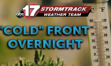
TODAY: Much like Monday, Tuesday starts in the upper 60s with abundant sunshine. With more of a south wind element in today’s forecast, expect temperatures to climb 5 to 10 degrees warmer. Officially, today’s forecast for Columbia sits at 97. TONIGHT: Late Tuesday night cloud cover will increase, and a wind shift will occur as
Continue Reading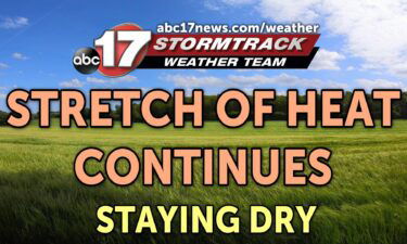
TONIGHT: Mostly clear and warm with lows in the upper 60s to around 70. TOMORROW: Mostly sunny and hot with highs in the upper 90s. Heat index between 100-102. EXTENDED: Dew points remain in the mid-upper 60s the next few days, so while our temperatures will be 7-10 degrees warmer than normal every day, the
Continue Reading
TODAY: Monday marks the return of a sunnier forecast, after weekend rain. After some picked up more than half an inch, little rain looks to populate the next 7 days. High pressure keeps sunshine in the forecast Monday, with a high near 90. TONIGHT: High pressure is slowly exiting overnight, but it keeps conditions ripe
Continue Reading Tonight: Showers and storms will push out of Central Missouri by 10 PM tonight as a cold front pushes to the southeast. Skies become partly cloudy as lows cool to the upper 60’s. Tomorrow: Temperatures warm near 90 degrees Monday with mostly clear skies. Winds remain out of the north at 5 mph as the
Continue Reading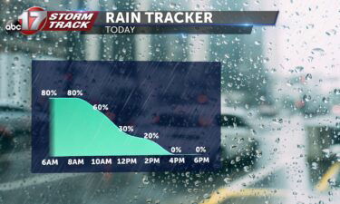
TODAY: Widespread showers and storms throughout the morning and early afternoon. Heavy downpours and lightning are possible before rain exits midday. Areas east of highway 63 will see the greatest rainfall totals Sunday between 0.5″-1″. Highs fall to seasonable levels in the mid to upper 80s. TOMORROW: Mostly sunny with near-average highs in the low
Continue Reading Tonight: Scattered showers and storms will continue throughout Saturday night as temperatures cool to the lower 70’s. Lightning and some strong downpours will be possible. Tomorrow: Showers and storms will become more widespread by Sunday morning aiding in diminishing short term drought conditions. Areas east of highway 63 will see greatest rainfall totals between 0.5″-1″.
Continue Reading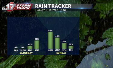
TODAY: Mostly sunny with increasing clouds. Highs in the mid-90s with a chance for storms by the evening. TOMORROW: Showers and storms diminish in coverage throughout the day. Highs reach the upper 80s under partly cloudy skies. EXTENDED: A push of more widespread rain and storms ahead of a cold front will move into Mid-Missouri
Continue Reading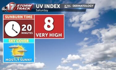
Saturday’s UV index will be higher due to more sunshine. Sunburn time will be between 20-30 minutes. Pollen levels continue to be low over the weekend. her
Continue Reading
TONIGHT: Mostly clear with lows in the low 70s. TOMORROW: Mostly sunny with increasing clouds. Highs in the mid-90s with storms developing by early evening. EXTENDED: Most of tonight stays dry and clear with the next complex of storms just clipping us to the east overnight. We’re off to a hot start to the weekend with sunshine
Continue Reading
TODAY: Showers with a few rumbles of thunder will arrive in our northwestern most counties around sunrise. Throughout the morning, these showers will continue to weaken, bringing light to moderate rainfall primarily across the northern half of mid-Missouri. Generally less than a tenth of an inch is expected, with most of us picking up near
Continue Reading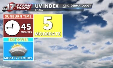
The UV index will be lower tomorrow due to the potential of rain and cloud cover. Grasses, plantain, and nettle levels continue to be low through the weekend.
Continue Reading
Dr. Anthony Lupo and Joseph Renken lead the way along with Caleb Brown, Grace Kennedy, Jacques Mainguy, Nicholas Wergelas into research connecting severe weather outbreaks in the United States and the Pacific tropics. This research ties information produced out of the Southern Oscillation Index to the upper level jetstream. The Southern Oscillation collects data depicting
Continue Reading
TONIGHT: Mostly clear early with increasing clouds overnight. Lows in the lower 70s. TOMORROW: Scattered showers and storms for much of the day, highs in the lower 90s. EXTENDED: Tonight, we’ll remain dry with increasing clouds overnight as showers and storms move in from the north by mid-morning. Scattered showers and storms will continue through
Continue Reading Today: Temperatures look to continue to increase into the mid-90’s while the humidity increases making for warmer conditions. Winds remain out of the south at 5-10 mph. Tonight: Skies remain mostly clear tonight as the overnight lows cool to the lower 70’s. Winds remain out of the south at 5-10 mph. Extended: A low pressure
Continue Reading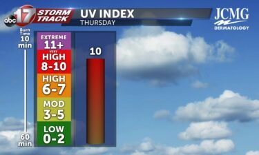
Skies remain mostly sunny Thursday with the UV Index at 10
Continue Reading
TODAY: Starting in the upper 60s this morning and landing in the 90s this afternoon, Thursday is shaping up very similar to Wednesday, just a few degrees warmer. Mostly sunny skies, and highs in the mid-90s are expected with a south breeze this afternoon. TONIGHT: Skies stay clear through the evening, before beginning to cloud
Continue Reading Tonight: Skies remain clear overnight with temperatures cooling to the upper 60’s. Winds begin out of the northeast and slow switch from the southeast at around 5 mph. Tomorrow: Skies remain mostly sunny as temperatures increase above Wednesday’s highs into the mid-90’s. Winds remain out of the south at 5-10 mph as conditions remain dry.
Continue Reading
TODAY: A clear and calm start this morning has us starting in the low 60s Wednesday morning. Skies stay clear today, and warm us into the low 90s this afternoon. With dew point values in the 50’s this afternoon, today’s heat should be relatively tolerable. TONIGHT: With surface high pressure near by, it will be
Continue Reading