
Drought conditions continue in Mid-Missouri despite severe storms
Although several areas throughout Mid-Missouri got some much-needed rainfall Tuesday, over half of the state is still experiencing a drought.
Continue Reading Although several areas throughout Mid-Missouri got some much-needed rainfall Tuesday, over half of the state is still experiencing a drought.
Continue Reading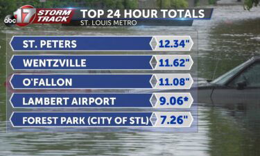
Showers and storms have calmed down this afternoon across Mid-Missouri, but more stronger downpours and storms are expected once again overnight. When it comes to driving in flash floods, it really doesn’t take much to sweep a car off of its path and leave you stranded. Strong and prolonged showers and storms waned down across
Continue Reading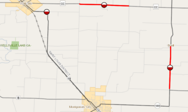
Part of Business 54 in Mexico was closed Tuesday afternoon because of continued flooding from overnight and morning rains.
Continue Reading
TONIGHT: Mostly cloudy with rain and storms moving in late, 72. Additional rain between 1-1.5″. TOMORROW: Morning showers and storms subside with partly cloudy skies by late afternoon. Highs in the mid-80s with a chance of an isolated storm. EXTENDED: Unfortunately, this morning’s heavy rain won’t be the last for the week, but the good
Continue Reading
ST. CHARLES, Mo. (KMIZ) Record rainfall led to water rescues and closed roads Tuesday morning in the St. Louis area. The rainfall closed major roads including part of Interstate 70 in St. Charles County and led to rescuers evacuating residents in boats in some areas. Lanes were closed in both directions near Mid Rivers Mall
Continue Reading
The UV index will be a bit higher with more sunshine expected between clouds Wednesday afternoon. Pollen levels get higher toward the end of the week as clouds clear out.
Continue Reading
TODAY: After heavy rain created flooding concerns for folks along and north of I-70, scattered showers and storms will continue Tuesday. Heavy rain will remain a concern for folks north of I-70 through mid-morning. A lull in precipitation will com through mid-day. Some light shower activity is possible through the early afternoon, but by the
Continue Reading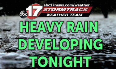
TONIGHT: Scattered showers and storms becoming more widespread north of I-70 overnight. Lows in the upper 60s. TOMORROW: Scattered showers and storms with dry time in between. Highs near 90. EXTENDED: Light showers continue to thin out the next few hours, but the lull won’t last all night with another round of heavy rain developing
Continue Reading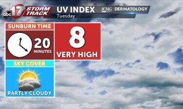
The UV index will be a bit higher on Tuesday with heavy rain exiting early. Pollen levels will be a bit higher on Wednesday and Friday with less rain during the day.
Continue Reading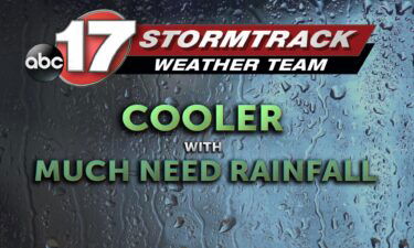
TODAY: After a brief stint of rainfall on Sunday, a better chance for rain comes area wide with scattered showers and storms throughout the day. A stationary boundary has storms ongoing near the lake and I-44 this morning. Rain chances will lift to the north through the morning. By this afternoon, a better chance for
Continue Reading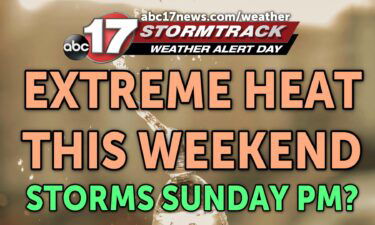
TONIGHT: Mostly clear and warm with lows in the mid-70s. TOMORROW: Hot and humid with highs near or just above 100. Heat index between 103-109. EXTENDED: The Weather Alert Day has been extended through Sunday with highs near 100 and a heat index from 103-106. Thankfully, we’re tracking a pattern change into next week as
Continue Reading
After an extremely warm week across Mid-Missouri and much of the country, we’re finally seeing a big pattern change this week with cooler temperatures and daily chances of much needed rain. Rain could be heavy at times tonight into Tuesday, and a Flood Watch is in effect until Tuesday morning at 9:00 for areas along
Continue Reading
TONIGHT: Showers and storms developing overnight, increasing in coverage by daybreak. Lows in the upper 60s to around 70. TOMORROW: Showers and storms likely. Highs in the upper 70s to around 80. EXTENDED: We’re tracking a slow-moving front that has triggered a few spotty showers and storms, t widespread development isn’t expected until late tonight
Continue Reading
The ABC 17 Stormtrack Weather Team has issued a Weather Alert Day through Sunday as dangerous heat continues to impact much of the country, including Mid-Missouri. Heat index values could reach 105-110 degrees, making it tough to complete any work or exercise outdoors. A Heat Advisory is in effect for the entire area through 7:00
Continue Reading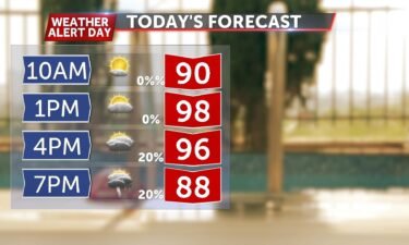
TODAY: Building clouds, summery with highs in the upper 90s. Heat index from 102-106. Scattered storms are possible throughout the late afternoon. TOMORROW: Widespread showers and storms during the morning becoming more isolated late in the day. Highs plummet to below average in the low 80s. EXTENDED: A few afternoon storms could produce high winds
Continue Reading
TONIGHT: Mostly clear and hot with lows falling into the upper 70s to around 80. TOMORROW: Increasing clouds, hot and humid with highs in the upper 90s. Heat index between 103-106. Storms develop by late afternoon and could bring heavy rain and strong winds through sunset. EXTENDED: We’ll stay quite warm this evening with lows
Continue Reading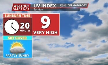
Sunday’s UV index will be slightly lower with clouds moving in early in the day. Pollen levels drop off a lot next week with rain in the forecast almost each day.
Continue Reading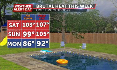
TODAY: Dangerously hot and humid with highs above 100 degrees. Heat index from 103-110. TOMORROW: Another muggy start with highs close to triple digits and a heat index from 103-106. EXTENDED: Weather Alert Days are in effect all weekend so stay prepared for the sizzling conditions! Thankfully, we’re tracking a pattern change into next week
Continue Reading
With dangerous heat making another return to much of the Midwest, the cost of keeping cool has skyrocketed. Forecasted highs are expected into the triple digits with the heat index in some areas reaching possibly 108 degrees for Saturday. Currently winds in the lower jet stream are surging out of the southwest. This means winds
Continue Reading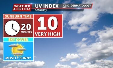
The UV index continues to be high on Saturday with a sunburn time of 20 minutes. Pollen levels drop a bit on Monday with rain and storms in the area.
Continue Reading