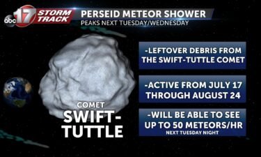
VIDEO: What to know about the Perseid meteor shower
NASA’s in-depth article on the 2020 Perseid meteor shower
Continue Reading NASA’s in-depth article on the 2020 Perseid meteor shower
Continue Reading
TODAY: A few clouds are passing through the area with a weak storm system. Temperatures continue to remain comfortable in the low 80s. TONIGHT: Rain and thunderstorms are a possibility in the early morning hours as we transition into Friday. Lows will fall into the mid 60s. EXTENDED: A warm front will continue pushing through
Continue Reading
TONIGHT: Partly cloudy to mostly clear with lows in the upper 50s to around 60. TOMORROW: Partly cloudy and warmer with highs in the low 80s. A few storms possible well after midnight going into Friday. EXTENDED: After a gorgeous few days to start the week, the upper level pattern will undergo some major changes
Continue Reading
THIS AFTERNOON: Gorgeous weather! Temperatures remain in the 70s with lots of sunshine! Enjoy it! A pleasant evening will follow. TONIGHT: Mostly clear skies overhead will lead to another cool night. Overnight lows fall into the upper 50’s and low 60’s. EXTENDED: Temperatures start to creep up along with the humidity Thursday into the low 80’s. That warming
Continue Reading
WEDNESDAY: Another spectacular afternoon lining up with highs in the mid to upper 70’s. A mix of sun and clouds looks to be the case once again this afternoon with a southerly wind between 5-10 mph. TONIGHT: Mostly clear skies overhead will lead to another cool night. Overnight lows fall into the upper 50’s and
Continue Reading
TONIGHT: Becoming mostly clear with light winds. Lows in the low to mid-50s. TOMORROW: Patchy fog early, east of Highway 63. Partly to mostly sunny with highs in the upper 70s. EXTENDED: The upper level pattern begins to shift by the end of the week with upper high pressure moving east over the Midwest by
Continue Reading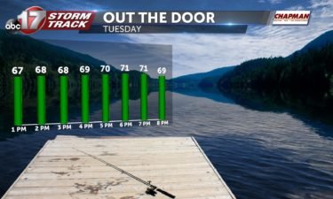
TUESDAY: We’ll get another treat this afternoon with highs in the middle 70’s! Some clouds will linger through the day, but we’ll be staying dry for our Tuesday. TONIGHT: Another cool night under mostly clear skies. Lows will fall into the upper 50’s. EXTENDED: Sunshine will dominate for Wednesday, but things will begin to change on Thursday. Temperatures
Continue Reading
TUESDAY: We’ll get another treat this afternoon with highs in the middle 70’s! No humidity problems to speak of but we will be in and out of the clouds throughout the day. Remember the sunscreen with a high August sun can still burn quick, when it is out. TONIGHT: Another cool night under mostly clear
Continue Reading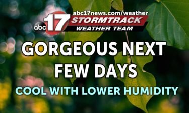
TONIGHT: Partly cloudy and cool with lows in the mid-upper 50s. TOMORROW: Increasing clouds with low humidity and highs in the mid-upper 70s. EXTENDED: Upper level high pressure keeps us cooler than average for much of this week as dew points stay in the 50s. By the end of the week, the jet stream begins
Continue Reading
MONDAY: A frontal boundary is in the process of moving through this morning. This could be just enough to get a shower or two going down near I-44 but most will stay dry. Temperatures this afternoon will be pleasant, in the low to mid 70’s. TONIGHT: One of the cooler nights we’ve seen in a
Continue Reading
TONIGHT: Rain chances increase throughout the early evening hours as a cold front leaves the area. Conditions begin to clear out around 9 PM. Temperatures tonight will fall into the low 60s. MONDAY: Scattered rain showers may be possible throughout the early morning hours, but these will dissipate as you make your way out the
Continue Reading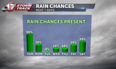
TODAY: Morning showers are continuing to push through the viewing area. This afternoon we’ll see more widespread storms across mid-Missouri, and temperatures will remain in the upper 70s to lower 80s. TONIGHT: Rain showers may linger into the early morning hours on Monday, but conditions will begin to dry out. Lows will be in the
Continue Reading
TONIGHT: Conditions remain calm and cool as temperatures fall into the mid 60s. SUNDAY: Things staying dry for the AM hours. A cold front will begin making its way through Missouri, giving us the possibility for some showers after lunchtime. As the front makes its way out of the area, things will start calming down
Continue Reading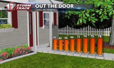
TODAY: This morning we are tracking some showers, especially in our eastern counties, but conditions should begin to dry out as we push toward the afternoon. Mostly cloudy skies will be the story with temperatures in the low 80s. TONIGHT: Conditions remain calm and cool as temperatures fall into the mid 60s. EXTENDED: An upper
Continue Reading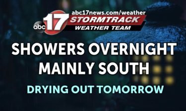
TONIGHT: Scattered showers will be slow to move out of the southern half of the state this evening, giving us an additional 0.5″ to 1″ for areas near the Lake of the Ozarks and I-44. Lows fall into the low to mid-60s. TOMORROW: Mostly cloudy with a few sprinkles to start, becoming partly sunny. Highs
Continue Reading

FRIDAY: Showers are still sticking around this morning but will try to shift south throughout the day. These scattered showers will stick around for the first part of the day, but into the afternoon will start that transition. Another day of rain chances and cloud cover will keep temperatures near 80. TONIGHT: Areas near I-44
Continue Reading
Cole County Public Works Director, Larry Benz said the county saw five inches of rain Thursday night leaving behind flooding in parts of Brazito.
Continue Reading
TONIGHT: Mostly cloudy with scattered showers and a few rumbles of thunder. Mostly cloudy with lows in the upper 60s to around 70. TOMORROW: Mostly cloudy with a chance for showers and storms, especially south of Highway 50. Highs in the upper 70s to around 80. EXTENDED: Low pressure moves east Friday into Saturday, taking
Continue Reading
We’ve gotten a break from the 90s this week but the humid, muggy weather has held on strong. That’s set to change as a strong cold front is set to burst south through mid-Missouri Sunday night. Much drier air will help us cool off into the 70s for highs with lows into the mid-to-upper 50s–
Continue Reading