
MODOT reminds drivers to travel safely this winter
The Missouri Department of Travel’s website has guidance for drivers as winter weather creeps into Mid-Missouri.
Continue Reading The Missouri Department of Travel’s website has guidance for drivers as winter weather creeps into Mid-Missouri.
Continue Reading
OSAGE BEACH, Mo. (KMIZ) Storms caused severe damage in Osage Beach according to the Missouri State Highway Patrol. Troop F said in a tweet people should avoid the area at this time. More pictures coming in. Please avoid the area. pic.twitter.com/l6aICTeJpO— MSHP Troop F (@MSHPTrooperF) November 15, 2020 MSHP said no injuries are reported at
Continue Reading
Get a live update on storms moving into Mid-Missouri.
Continue Reading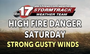
A Weather Alert Day has been issued ahead of strong, potentially damaging winds today. Despite expected warmer temperatures this afternoon, it will be tough to spend much time outside with strong gusty winds expected out of the southwest. A deep area of low pressure to our northwest will battle with high pressure to our southeast,
Continue Reading
The Jefferson City Council unanimously approved a demolition project for a building on East Capitol Avenue during its Monday night meeting.
Continue Reading
Cole County Public Works Director, Larry Benz said the county saw five inches of rain Thursday night leaving behind flooding in parts of Brazito.
Continue Reading
The Jefferson City Fire Department responded to at least 25 incident Sunday as a severe thunderstorm swept through the area.
Continue Reading
A line of severe thunderstorms blossomed across the Highway 50 corridor this evening. It brought extremely heavy rainfall to Moniteau and Cole Counties. Flooding was reported on several roadways near creeks and streams in Jefferson City. A flash flood warning remains in effect until 11:15pm for Moniteau, Cole and Southern Callaway Counties. Radar indicated rainfall
Continue Reading
Col. William Hannan, commander of the Kansas City District, gave an update on levee rehab across the state and said that Jefferson City is further along than most.
Continue Reading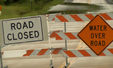
Roads across Boone County remained flooded Wednesday morning after rain plagued mid-Missouri Tuesday.
Continue Reading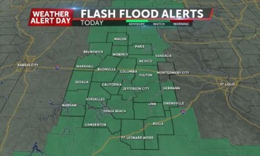
The ABC 17 Stormtrack Weather Team has issued a Weather Alert Day for the threat of severe storms through Thursday morning. MIDNIGHT UPDATE: Strong storms have been training across the eastern half of Mid-Missouri this evening, bringing anywhere from 2-4″+ rainfall to parts of Audrain, Callaway, Boone, Monroe, and Randolph counties. These storms will continue
Continue Reading
Scattered thunderstorms brought heavy rain and flash flooding to parts of Mid-Missouri on Monday night, along with a brief tornado in northern Chariton County. A brief tornado touched down after 6:00 PM on Monday, May 25, 2020. Photos courtesy of Riley Young. Minor structural damage was found near Mendon at the intersection of Mike Rd.
Continue ReadingJefferson City and Eldon continue to recover one year after a devastating EF-3 tornado hit on May 22, 2019.
Continue Reading
Just before 11 p.m. on May 22, 2019, a small town in northern Miller county just off Highway 54 would hear the sounds of sirens.
Continue Reading
On the one-year anniversary of the tornado that touched down in Jefferson City, the city held a ceremony to celebrate the first wall being put up for a home going to a victim’s family.
Continue Reading
Stubborn clouds have plagued Mid-Missouri over the last several days thanks to slow moving low pressure that has drifted to our southeast. We begin to see a change in our weather pattern by Friday with this low affecting us less as we approach the weekend. Our upper level pattern with shift with southwest wind flow,
Continue Reading
The track of the storm on May 22, 2019, was long enough to give Jefferson City a chance to get ready.
Continue Reading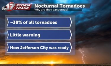
Nocturnal tornadoes, or tornadoes that come at night, make up roughly 38 percent of all tornadoes in the United States.
Continue Reading
Thursday Night Update: A line of strong storms capable of producing damaging winds is pushing into our far northern counties along Highway 36 and will continue to pose a damaging wind and large hail threat into the overnight hours. A Severe Thunderstorm Watch is in effect until 5AM for areas along and west of Highway
Continue Reading
TONIGHT: Scattered strong storms early, with a line of damaging winds and heavy rain expected late into the overnight hours. Rainfall could amount to 2-3″. Lows remain in the lower 60s. TOMORROW: Mostly cloudy with a few spot showers or storms. Highs in the upper 70s. EXTENDED: The wavering cold front will retreat back north
Continue Reading