
Reports of icy conditions in Boone County on Monday morning
Boone County first responders said five vehicles were involved in a weather-related crash near Sturgeon.
Continue Reading Boone County first responders said five vehicles were involved in a weather-related crash near Sturgeon.
Continue Reading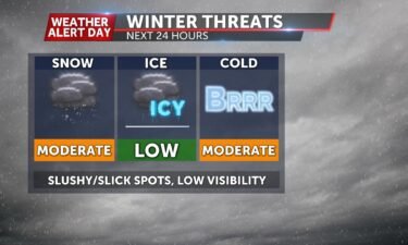
TONIGHT: Mostly cloudy and chilly with lows in the mid-upper 30s. Breezy with winds from the northwest between 10-20 mph. TOMORROW: A Weather Alert Day is in effect for the threat of light snow accumulation and moderate road impacts. Snowfall will be most likely west of Highway 63 and north of I-70. Amounts range between
Continue Reading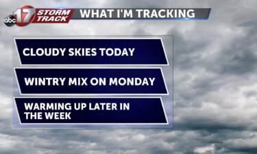
TODAY: Cloudy skies will stick around as temperatures stay in the upper 40s. There’s a chance for spot showers beginning this afternoon and continuing into the evening. MONDAY: Rain begins in the morning hours and continues throughout the day. This could become mixed with some snow in some counties along I-70. To the north, small snow
Continue Reading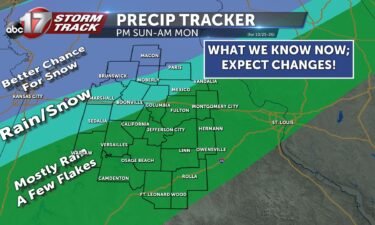
TONIGHT: Cool and calm conditions will continue as lows fall into the upper 30s and lower 40s. SUNDAY: Spot showers will begin moving in through the afternoon and keep temperatures in the upper 40s for a chilly and wet end to the weekend. EXTENDED: Rain will continue and become more widespread into Monday as cold
Continue Reading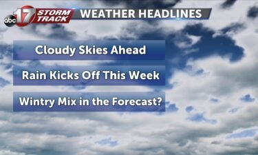
TODAY: Clouds will stick around for most of today as temperatures rise into the low 50s. SUNDAY: Another chance for showers will start the week off. These start moving in through the afternoon and keep temperatures in the low 50s for a chilly and wet end to the weekend. EXTENDED: Rain will continue into Monday
Continue Reading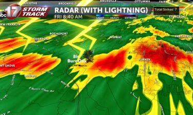
Texas A&M Forestry Study on Tree Strikes
Continue Reading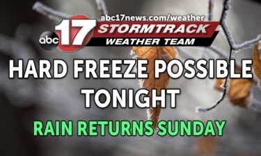
TONIGHT: Partly cloudy and breezy early with lows falling into the low 30s. A hard freeze is possible for areas north of Highway 24 and along Highway 65. TOMORROW: Decreasing clouds with temperatures rising into the low 50s. EXTENDED: Clouds return overnight into Sunday, keeping temperatures in the upper 30s to around 40 by Sunday
Continue Reading
FRIDAY: Showers and storms will move through this morning. Nothing strong or severe is expected, but a few rumbles of thunder will greet some of us out the door. These storms will slide southeast of the area toward midday. Temperatures will fall back into the 40’s, where they’ll stay even into this afternoon with a
Continue Reading
TONIGHT: Increasing clouds and mild early. Lows in the mid-40s by tomorrow morning. Storm chances increase after midnight with heavy rain at times. TOMORROW: Showers and thunderstorms in the morning followed by a chilly northwest breeze. Highs in the mid-upper 40s. EXTENDED: As the front clears out of Mid-Missouri, temperatures rapidly drop Friday night into
Continue Reading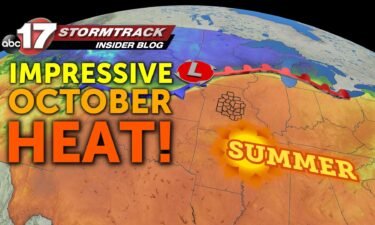
Today’s near-record heat The official high at Columbia Regional Airport was 84º. This was just shy of the record of 88º set back in 1899. Most of our feels like temperatures were pretty close to this today, though. Hot and steamy weather took off today with a warm front pushing off to the north. The
Continue Reading
THIS AFTERNOON: Summer making a cameo appearance this afternoon. Impressive warmth and humidity for late October! Expect that warmth to continue through the evening, no jacket needed if you’re heading out. We’ll see clear skies. TONIGHT: Cold front quickly approaches from the northwest and will push through after midnight. Expect quickly dropping temperatures and storms
Continue Reading
THURSDAY: A warm front brought us some fog overnight but that’s on it’s way out this morning. We’ll be left with some much-needed sunshine after a pretty gloomy week so far. Winds will pick up out of the south, with gusts up around 30-35 mph expected. That will push temperatures into the low to mid
Continue Reading
The peak of this meteor shower actually occurred early this morning, but clouds and rainfall kept mid-Missouri from view. Tonight, with clouds expected to lift to the north, we should clear out enough to see this celestial phenomenon. The Orionids get their name due to their proximity to the Orion constellation. Up to 10 meteors
Continue Reading
TONIGHT: Partly to mostly cloudy and cool with temperatures increasing into the upper 50s to around 60 overnight. Showers stay mainly north. TOMORROW: Mostly sunny and breezy with highs in the low to mid-80s. Record high temperatures will be in jeopardy. Wind gusts reach 25 mph from the south/southwest. EXTENDED: A cold front to our
Continue Reading
THIS AFTERNOON: Spotty showers and a few thunderstorms (which could produce pea-sized hail) continue to lift ENE across mid-Missouri this afternoon. We’re not tracking any severe storms, but locally heavy downpours and lightning are the main threats. TONIGHT: Clouds look to stick around long enough and winds will start to swing out of the south. Both of
Continue Reading
WEDNESDAY: Spotty showers will dot the radar again today. Much like yesterday, they won’t be terribly organized or large, but can bring a quick downpour. The favored area for those will slide north of I-70 this afternoon before exiting the viewing area that direction tonight. With clouds sticking around, temperatures look to top out in
Continue Reading
TONIGHT: Mostly cloudy and chilly with lows in the low 40s. A few showers possible south of Highway 50. Patchy fog developing overnight. TOMORROW: Partly to mostly cloudy and a bit warmer with highs in the lower 60s. A few showers or storms will be possible near a warm front, especially for the northern half
Continue Reading
We’re still a ways away… Heavy snow fell across Iowa yesterday… and today, more early-season snow across Minnesota. Now, it’s not uncommon these places see flakes fly this early, but to have major accumulations this early is impressive. Some locations broke all-time October records! Minneapolis with record-setting snow today… https://t.co/KarXBeVpQj— Capital Weather Gang (@capitalweather) October
Continue Reading
THIS AFTERNOON: Drizzle and light rain showers are expected to continue through the afternoon. The heavier rainfall, with embedded thunder will be more likely closer to the I-44 corridor. Temperatures will be variable– in the 50s along and north of I-70 and in the low to mid 60s further to the south. TONIGHT: Our better shot at
Continue Reading
TUESDAY: Rain chances look to move back in later this morning and will be hit-and-miss into the evening. More widespread activity looks to favor the evening, after temperatures top out in the upper 50’s to low 60’s. TONIGHT: Our better shot at picking up some meaningful rain looks to be after sunset, with even a
Continue Reading