Skip to Content

Weather

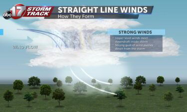
Tracking a blustery Monday

TODAY: After storms overnight, the remnants of this system will still have windy implications for us the rest of the day. Winds will be sustained around 15-25 mph, and potentially gust as high as 50 mph at times through the afternoon. Clouds will break shortly this morning, before they fill back in from the north.

Continue Reading

Tracking storms with severe potential

TODAY: Wednesday is a Weather Alert Day, as storms this morning and afternoon may pack a severe punch. While damaging winds are the most likely threat from this system, all severe types are possible, including the possibility of tornadoes. For more detail, read our latest blog. Otherwise, Wednesday will be warm, with temperatures approaching low-to-mid

Continue Reading

Tracking strong storms with heavy rain and wind early Wednesday

TONIGHT: Increasing clouds with warming temperatures overnight. Morning temperatures reaching the upper 50s to around 60. TOMORROW: Strong storms with heavy rain and potentially damaging winds through early afternoon. Highs reaching the mid-60s. Rain amounts between 1-1.5″. EXTENDED: A strong low pressure system is moving across the Plains tonight, bringing a warm front north across

Continue Reading