
Weather

Tracking fleeting warm weather
WEDNESDAY: Another toasty afternoon on tap once again. Just about the only saving grace we might find will be a spot shower. Most of that activity will once again be around the I-44 corridor, however. The rest of us will see highs in the low 90’s with a heat index in the upper 90’s. TONIGHT:
Continue Reading
Inside the Storm: How hurricane hunters stay safe flying through storms
Follow @TheAstroNick and @NHC_Atlantic on Twitter for lots of cool Hurricane Hunter updates! Today I installed a Turbulence Indicator (it's a dropsonde ribbon wrapped around a dropsonde cap and tied to the ceiling) to try to better illustrate the bouncing around. I think it works, personally.#Laura was a hurricane by this point but I hadn't
Continue Reading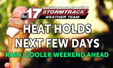
Tracking hot and humid next few days, late week rain
TONIGHT: Mostly clear and muggy with lows in the low 70s. TOMORROW: Mostly sunny and hot with highs in the low 90s. Heat index in the upper 90s to around 100. EXTENDED: Heat and humidity will be the rule over the next couple of days with upper high pressure centered over the Midwest. We’ll see
Continue Reading
Heat & humidity hold on for now…
THIS AFTERNOON: It’s a toasty one out there… most of the area will top out around 93/94. Hazy skies from wildfires and maybe a bit of a smoky smell certainly possible too. Clear weather will continue this evening, will be a good one for grilling on the patio! TONIGHT: Mostly clear skies stick around tonight with lows
Continue Reading
Tracking another sweltering afternoon
TUESDAY: Another hot and humid afternoon lining up. Highs will top out in the low to mid 90’s with heat index values in the vicinity of 100. Be sure to drink plenty of water and take breaks in the shade if you plan on any strenuous activities outdoors. TONIGHT: Mostly clear skies stick around tonight
Continue Reading
Tracking brutal heat and possible tropical rain this week
TONIGHT: Mostly clear and muggy with lows near 70. TOMORROW: Mostly sunny and hot with highs in the mid-90s. Humidity allows the heat index to rise to near 100 degrees. EXTENDED: The heat and humidity continues this week with an upper level ridge over us. Highs will be in the low to mid-90s through Friday,
Continue Reading
VIDEO: Stormtrack Weather Team explains how hurricanes form
NOAA article on hurricane formation and how they’re named
Continue Reading
Mother natures bring the heat this week!
THIS AFTERNOON: It’s a hot one out there right now. Temperatures will remain in the upper 80s through 7pm. We should remain mostly sunny this evening. Should be a good one to get out on the patio. TONIGHT: Things will be quiet overnight under mostly clear skies. Lows will back off into the upper 60’s by daybreak.
Continue Reading
Tracking a steamy start to the school year
MONDAY: It’s going to be another hot one as many head off to school today. Highs will top out in the low to mid 90’s with a heat index in the upper 90’s. One or two of us might pick up a stray shower this afternoon, but most of that will stay south of I-44.
Continue Reading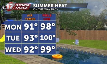
Tracking a warm start to the workweek
TONIGHT: Conditions will remain relatively clear and calm as we head into Monday. Temperatures will fall into the upper 60s. TOMORROW: Monday will be a tad bit humid in comparison to the past week, but still has potential to be comfortable with highs warming into the lower 90s. Grab that sunscreen and enjoy the plentiful
Continue Reading
Summer-like conditions for this workweek
TODAY: Stable conditions we saw the past few days will continue. Some portions of mid-Missouri will see mostly cloudy skies for the early AM hours but these thin out as the afternoon approaches. Temperatures will be slightly warmer with a high around 91. The humidity has also made a return; however, dew points look to be
Continue Reading
Another blast of summer on the way this week
TONIGHT: We’re tracking quiet conditions through this evening with clouds beginning to increase after midnight. A weak storm system could bring a few sprinkles to our northwestern counties around sunrise but most of that will dry up quickly after sunrise. SUNDAY: Once clouds thin out around lunchtime, expect the heat to crank up into the afternoon. Temperatures
Continue Reading Tracking an increase in heat and humidity
TODAY: Mostly clear with highs in the 80s. Humidity begins to rise. SUNDAY: Conditions similar to Saturday; temperatures begin to rise into the low 90s. The humidity will stay relatively comfortable but may aid in pushing the heat index up a few degrees. Very slight rain chances occur in the afternoon. EXTENDED: Things will remain stable in mid-Missouri
Continue Reading
Tracking the heat and humidity creeping back into mid-Missouri
TONIGHT: Mostly clear overnight with lows in the low to mid 60’s. SATURDAY: Expect another sunny, warm day tomorrow. Humidity will be tolerable, but definitely not as nice as most of the past week was. Expect temperatures to bubble up into the 80s by lunch to near 90 by the later afternoon hours. Clouds will
Continue Reading
Tracking a slightly warmer weekend moving in
FRIDAY: Another nice day to round out the week! Highs will be slightly warmer than we’ve experienced these last few days, in the middle 80’s. Humidity still not much of a problem, but there will be plenty of sunshine, so be ready for that. TONIGHT: Mostly clear overnight with lows in the low to mid
Continue Reading
Two tropical systems to strike at once? Historic tropical event possible next week
What we know now Tropical depression 13 and 14 continue to churn in the Atlantic basin Thursday afternoon. Both are expected to become named storms (winds of 39 mph or greater) within the next 24 hours. They would be Laura and Marco. Official tracks from the National Hurricane Center indicate both storms posing a threat
Continue Reading
Tracking a warm up for this weekend
TONIGHT: Mostly clear and comfortable with lows in the upper 50s to around 60. TOMORROW: Slightly warmer with continued low humidity. Highs in the mid-80s with sunshine. EXTENDED: The low dew points continue through Friday with low humidity, giving us another gorgeous day. An upper ridge moves east over the weekend, bringing temperatures back into
Continue Reading
Let the good times roll! Beautiful weather sticks around
THURSDAY: Sunny skies with highs in the low 80s can be expected this afternoon. Get out and enjoy the evening! TONIGHT: Mostly clear overnight with another cool one lining up. Lows will back off into the upper 50’s and low 60’s. EXTENDED: We’re tracking some slightly warmer weather tomorrow, with temperatures running into the middle
Continue Reading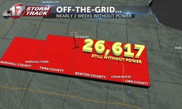
VIDEO: Nearly 30,000 Iowans still without power two weeks after derecho
⬇️Help our neighbors to the north⬇️ Greater Cedar Rapids Community Foundation GoFundMe for Individual Families Affected
Continue Reading