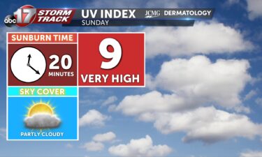
Sunday’s UV Index and Pollen Tracker
Sunday’s UV Index is a 9, meaning it will only take 20 minutes to receive a sunburn without the proper protection. Pollen levels will be high throughout the start of next week.
Continue Reading Sunday’s UV Index is a 9, meaning it will only take 20 minutes to receive a sunburn without the proper protection. Pollen levels will be high throughout the start of next week.
Continue Reading
TODAY: Temperatures remain hot today with mostly sunny skies. Highs reach the upper 80s. TOMORROW: Sunday feels better in the lower 80s with more clouds in the afternoon. Rain is expected to stay out to our southwest. EXTENDED: Quiet weather stretches into next week where rain holds off until at least midweek. The longer term
Continue Reading
TONIGHT: A few isolated storms remain possible with moderate downpours being the primary focus. Storms eventually cool as lows fall into the upper 60s. TOMORROW: Saturday sees highs into the upper 80s with mostly sunny skies. EXTENDED: A mild and quiet weekend is expected with sunshine and highs in the 80s. Dew points in the
Continue Reading
Almost three in four Americans drink a cup of coffee every morning but this popular pick-me-up could be getting more expensive. The global appeal of coffee makes it susceptible to worldwide changes in supply and demand and weather also plays a large role in how coffee is grown and transported. Coffee is grown in the
Continue Reading
THIS AFTERNOON: Partly cloudy with rain tracking by to our southwest. Isolated showers are possible in Sedalia and the Lake of the Ozarks this evening. Temperatures are still hot with highs reaching 90, feeling like upper 90s. TONIGHT: We cool down as a front slides south overnight. Lows fall to the upper 60s. EXTENDED: A
Continue Reading
TODAY: Partly Cloudy skies form by this afternoon as a wave passes by to our southwest. Some may see showers and thunderstorms from this wave. The greatest chance for rain will be from Sedalia to the Lake of the Qzarks and west. Temperatures are not as hot today, but still warm, with highs reaching 90,
Continue Reading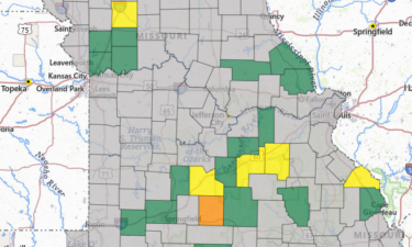
Hundreds of electric cooperative members lost power as storms moved through parts of mid-Missouri on Thursday night.
Continue Reading
TONIGHT: Strong to severe storms surge ahead of an incoming cold front lasting throughout the first half of the night. Winds up to 70 mph, hail up to 1.5″, and a low but not zero tornado chance remains possible tonight. Lows cool near 70 degrees. TOMORROW: Friday welcomes partly cloudy skies with highs up to
Continue Reading
THURSDAY AFTERNOON UPDATE: Little has changed in the forecast for Thursday night, other than the fact that we now have some added clarity of where and when the best chances for storms will be. We’ll have two primary rounds of storms. Our first window for sever weather will come with development in the south that
Continue Reading
TODAY: Thursday is an ABC17 Stormtrack Weather Alert Day. We’ll have a chance for severe storms including the chance for hail, damaging winds, and a possible tornado from 3 p.m. to around midnight. Additionally, it will be hot and humid, with highs ranging from high 80s in the north to mid-90s in the south. Some
Continue Reading
Thunderstorms in Mid-Missouri recently brought heavy rain and some incidents of flooding to the area. These storms have been efficient rainfall producers thanks to heavy moisture in the atmosphere, some storms hit rain rates up to 6″ at times. But this rate of rainfall isn’t the same as what is observed in rain gauges. The
Continue Reading
TONIGHT: Temperatures overnight cool into the lower 70s as winds continue out of the southeast at 5-10 mph. A few isolated showers/ storms remain possible with lightening and moderate downpours. TOMORROW: Thursday is an ABC 17 Stormtrack Weather Alert Day as two rounds of showers and storms push into the area. Early Thursday morning, a
Continue Reading
Heavy rainfall in Columbia led to flash flooding on some roads Wednesday.
Continue Reading
TODAY: Showers and storms are forecast this morning through the early afternoon. With efficient rainfall rates and potential for repetitive rain, we will have some potential for flooding. We are warmer today, but with rain and clouds, we still expect highs to be below average, in the low 80s. TONIGHT: Rain lets up this afternoon,
Continue Reading
CNN By Elizabeth Wolfe, Robert Shackelford and Mary Gilbert, CNN (CNN) — Hurricane Ernesto continued to unload flooding rainfall on Puerto Rico as it pulled away from the island Wednesday afternoon after its strong winds knocked out power to hundreds of thousands there and in the Virgin Islands. The Category 1 hurricane had maximum sustained
Continue Reading
TONIGHT: Scattered showers and storms remain possible overnight with lows into the upper 60s. Moderate downpours and lightening remain the main threats. Isolated flooding remains possible. TOMORROW: Wednesday morning welcomes more widespread showers and storms increasing the possibility of flooding with slower moving moderate showers. Highs increase into the mid-80s with a drier afternoon. EXTENDED:
Continue Reading
TODAY: Scattered showers and storms with moderate downpours and lighting continue across the region. Highs top out into the upper 70s. TONIGHT: Rain will taper off after sunset temporarily, but an increase in our low level winds will nudge a warm front north which will instigate widespread thunderstorms across the region. This likely fires up
Continue Reading
SETUP: A warm front will lift into the region, as our low level winds from the south ramp up behind it. This will generate storms along and parallel to the front late Tuesday night through Wednesday morning. Storms will have some motion parallel to the front thanks to a jet stream of the same orientation.
Continue Reading
TODAY: We’ll start dry with at most a few spotty showers through 7 a.m. Better shower coverage returns by 10 a.m. and persists through the afternoon into the evening. Thunder is unlikely with most rainfall, with the best chance at lightning coming near the Lake of the Ozarks in the afternoon. Temperatures will once again
Continue Reading
TONIGHT: Overnight lows cool to the mid-60s with a few isolated spotty drizzles possible. Winds remain out of the northeast at 2-5 mph. Patchy fog remains possible. TOMORROW: Tuesday sees scattered shower and storm chances into the afternoon hours. Highs remain into the upper 70s. EXTENDED: Shower and storm chances remain possible into Wednesday morning
Continue Reading