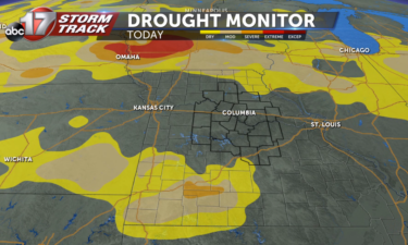
Dry weather ahead, minor drought grows toward mid-Missouri
LINK TO THE NATIONAL DROUGHT MONITOR: https://droughtmonitor.unl.edu/CurrentMap/StateDroughtMonitor.aspx?Midwest
Continue Reading LINK TO THE NATIONAL DROUGHT MONITOR: https://droughtmonitor.unl.edu/CurrentMap/StateDroughtMonitor.aspx?Midwest
Continue Reading
WEDNESDAY: Another quiet day looks to be in store. We’re tracking a disturbance that will bring a few more clouds but the sprinkles look to stay to our southeast. Highs look to top out in the low 80’s under another hazy sky. A frontal boundary will sneak through later today, but only looks to be
Continue Reading
PENSACOLA, Fla. (AP) Hurricane Sally made landfall near Gulf Shores, Alabama, as a Category 2 storm just before 5 a.m. Wednesday. The National Hurricane Center said Sally is bringing torrential rain over a coastal storm surge that will cause dangerous flooding from the Florida Panhandle to Mississippi and well inland in the days ahead. The
Continue Reading
TONIGHT: Partly cloudy to mostly clear. Lows in the upper 50s. TOMORROW: Few more clouds, but skies remain fairly hazy due to ongoing wildfires and associated smoke drifting in our direction along the jet stream. Highs in the low to mid-80s. EXTENDED: The remnants of Hurricane Sally will stay well to our south, but potentially
Continue Reading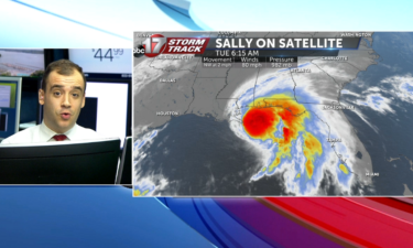

TUESDAY: Some more nice weather is in the cards today. A few more clouds will accompany us into the afternoon but sunshine looks to still be the dominant feature. Highs will warm slightly into the low 80’s. TONIGHT: Partly cloudy skies will stay with us tonight as lows back off into the upper 50’s. EXTENDED:
Continue Reading
TONIGHT: Mostly clear and cool with lows in the upper 50s. Patchy fog possible in low lying areas. TOMORROW: Mostly sunny to partly cloudy with highs in the low 80s. EXTENDED: We’re in for a beautiful week with minimal weather impacts for much of the next 7 days. By Wednesday, we’ll be watching for cloud
Continue Reading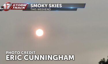
Smoke from wildfires out west has plumed towards the Midwest. This can happen from time to time as wildfire season gears up across the United States. This weekend, smoke was particularly thick and left mid-MO skies a hazy, milky grey, versus a typical clear-day blue sky. Below is a map of where smoke has spread
Continue Reading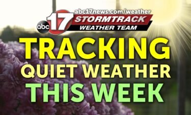
THIS AFTERNOON: Beautiful afternoon looks to be in store. Expect upper 70s/low 80s with lots of sun. Milky skies, especially along and south of I-70 is upper-level smoke that continues to filter into the area from wildfires out west. We’re expecting to stay dry. TONIGHT: Mostly clear skies overhead will lead to a cool night again, with
Continue Reading
MONDAY: Some low-lying areas could wake up to fog this morning, but that will lift by 10 AM. Sunshine will be the dominant feature today again, with highs in the upper 70’s and low 80’s. Humidity will be kept in check, so get out and enjoy this weather! TONIGHT: Mostly clear skies overhead will lead
Continue Reading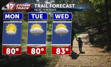
TONIGHT: Calm and cool conditions will continue through the evening as lows fall into the mid 50s. TOMORROW: Monday will kick off a beautiful week of seasonable temperatures with highs in the lower 80s and sunny skies. EXTENDED: Conditions will stay very similar each day, but we do have the opportunity to see temperatures fall
Continue Reading
TODAY: Sunday is going to be very pleasant with high temperatures today reaching into the upper 70s. The sun will be out for the whole day with some scattered clouds. We’ll also feel a bit less humid so today is the day to get outside and soak in the sun! MONDAY: Humidity makes a small return but
Continue Reading
TONIGHT: Conditions will largely remain calm this evening, but there is a small possibility for some spot showers and storms to make their way through the northern parts of the viewing area. Lows will fall into the mid 50s. TOMORROW: The sun will finally make a comeback as we kick off a stretch of some
Continue Reading
TODAY: Scattered storms continue for most of the morning. Rain will make an exit by the afternoon as the sun begins to peek out again. Temperature will stay cool in the mid to upper 70s. SUNDAY: Clear conditions as the sun sticks around and we begin to warm up again. Temperatures will rise to the
Continue Reading
TONIGHT: Mostly cloudy with scattered to numerous showers and thunderstorms. Heavy rain is possible north of I-70 where 1-3″ of rain could fall. Lows in the low to mid-60s with morning patchy fog likely in a few spots. TOMORROW: Scattered showers east of Highway 63 with mostly cloudy skies, becoming partly cloudy by afternoon. Highs
Continue Reading
Light rain and gloomy skies have been plaguing Mid-Missouri for most of Friday, but storms increase in coverage overnight into Saturday morning along a pre-frontal boundary draped north to south across the state. The National Weather Service has issued a Flash Flood Watch from 7PM through 10AM Saturday for the potential of isolated flash flooding
Continue Reading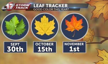
Fall foliage has already begun to pop across the upper Midwest and Rockies, likely aided by the big-time cooldown experienced in that part of the nation this past week. Our foliage tracker has mid-Missouri hitting peak color by late October and early November. For those with a keen eye, there have already been some leaves
Continue Reading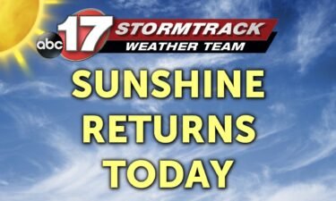
THIS AFTERNOON: Clouds continue to hold strong across most of the viewing area. Spotty mist/drizzle is possible. Some heavier showers can’t be ruled out either. Depending on if a little bit of sunshine can get going, a few storms could pop up into the early evening hours– something to watch out for the evening HS
Continue Reading
FRIDAY: Another foggy start greeting mid-Missouri out the door this morning. A few showers will be possible after the fog lifts around 10 AM but will stay on the light in nature. Some heavier pockets of rain will develop this afternoon and evening, just in time for the evening commute and some area high school
Continue Reading
TONIGHT: Scattered to spotty showers and mostly cloudy. Patchy fog possible overnight. Lows in the low 60s. TOMORROW: Foggy morning with scattered showers throughout the day. Highs in the low 70s. EXTENDED: The front responsible for our wild temperature swings and rounds of rain and clouds this week will begin to lift north Friday night
Continue Reading