Weather
Tracking dangerous heat before Tuesday showers and storms
TODAY: Monday is an ABC17 Stormtrack Weather Alert Day. Temperatures near 100 and dewpoints in the 70s will yield air that feels like 105-110. We’ll be mostly sunny, with a southwest wind at 5-10 mph. TONIGHT: It will be a war night as well, with lows in the mid-70s. Storms from Iowa will blow through the
Continue Reading
Tracking extreme heat on this side of a passing cold front
TODAY: Monday is an ABC17 Stormtrack Weather Alert Day. Temperatures near 100 and dewpoints in the 70s will yield air that feels like 105-110. We’ll be mostly sunny, with a southwest wind at 5-10 mph. TONIGHT: It will be a war night as well, with lows in the mid-70s. Storms from Iowa will blow through
Continue Reading
Tracking triple digit heat indices Monday, rounds of rain and storms by midweek
TONIGHT: Mostly clear and muggy with lows in the mid-70s. TOMORROW: Mostly sunny and brutally hot with highs in the upper 90s. Heat index values between 105-110 degrees. EXTENDED: Tomorrow will be the hottest day with highs in the upper 90s and a heat index between 105-110. Tuesday is starting to look a bit more
Continue Reading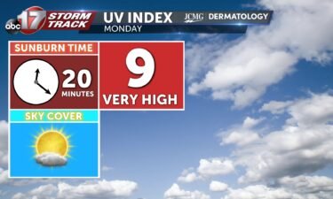
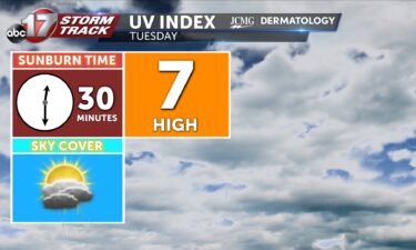
Monday’s UV index and pollen tracker
The UV index remains high on Monday and pollen levels stay fairly low for the week ahead.
Continue Reading
How to keep children safe in a heat wave; 10 reported deaths in the US in 2024
COLUMBIA, Mo. (KMIZ) As temperatures continue to rise in the coming days, experts are reminding people that it will be even hotter inside a vehicle. According to No Heat Stroke, the temperature inside a vehicle can be up to 50 times higher than outside. This year, 10 children have died nationally after being left in
Continue Reading
Tracking a stretch of brutal heat
TODAY: Partly cloudy and hot with highs in the mid-90s. The heat index ranges from 103 to 108 degrees. TOMORROW: Monday will be the worst with the heat index more easily above 105 across the area. EXTENDED: Try to limit outdoor exposure as much as possible through Tuesday with the heat index well into the
Continue Reading
Tracking dangerous heat starting tomorrow, triple digit heat through Tuesday
TONIGHT: Mostly clear and muggy with lows in the mid-70s. TOMORROW: Mostly sunny and hot with highs in the mid-90s. Heat index in the 104-108 degree range. EXTENDED: Dangerous heat and humidity settle in as upper high pressure takes hold across Mid-Missouri for the next few days. Try to limit outdoor exposure as much as
Continue Reading

Tracking a dangerous warmup settling in
TODAY: Isolated showers and storms are possible through the early afternoon but most stay dry. The rain and accompanying clouds at least limit the heat today compared to the end of the weekend. The heat index this afternoon still reaches 100 degrees in some spots. TOMORROW: The first of a string of Weather Alert Days
Continue Reading
Tracking isolated storms before dangerous heat beginning Sunday
TONIGHT: Isolated showers and storms remain possible with most of Mid-Missouri staying completely dry. Overnight lows cool to the lower 70s with winds out of the south at 5-10 mph. TOMORROW: Isolated showers and storms remain possible with most of Mid-Missouri remaining dry once again. Areas that see storms can still expect plenty of dry
Continue Reading
Tracking less rain and more heat into the weekend
TODAY: Even hotter temperatures today will push down on storm chances and keep the majority of Mid-MO dry. Highs reach the upper 80s and heavy humidity pushes the heat index into the 90s. THIS EVENING: Conditions remain clear through sundown while more rain develops late overnight. Lows will remain warm in the 70s. EXTENDED: The
Continue Reading Tracking slim rain chances and a dangerous warmup
THIS MORNING: Isolated morning storms may bring lightning and downpours in spots. Most stay dry and mild warming quickly to the 80s before noon. TODAY: Mostly sunny and humid with highs in the upper 80s. The heat index reaches the mid-upper 90s. A few isolated storms remain possible through the day. EXTENDED: The weekend is
Continue Reading
The science behind vibrant sunsets
Each evening brings the opportunity for vibrant orange and red hues to be reflected upon the afternoon skies. There is a bunch of factors that determine the colors seen throughout our atmosphere. To understand these factors, one must start with why the skies changes colors during the day. It has to do with the suns
Continue Reading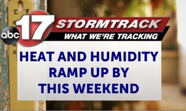
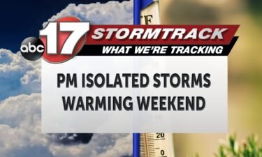
Tracking a few storms, dangerous heat by the end of the weekend
TONIGHT: Partly cloudy to mostly clear with a few isolated storms. Lows in the upper 60s to around 70. TOMORROW: Mostly sunny and humid with highs in the upper 80s. Heat indices reaching the mid-upper 90s. A few isolated storms possible. EXTENDED: Storms this evening will be very hit and miss, but wherever they pop
Continue Reading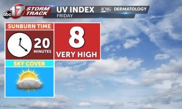
Tracking spotty pm storms with rising temps into weekend
TODAY: Isolated showers and storms remain possible with moderate downpours and lighting as the main threats. Highs warm into the mid-80s. TONIGHT: Overnight scattered showers and storms remain possible as lows cool to the upper 60s. EXTENDED: Hit-or-miss storms remain possible into the early weekend but most of us stay rain-free while temperatures gradually warm.
Continue Reading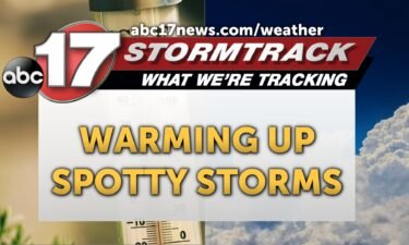
Tracking climbing temperatures and spotty storms
THIS MORNING: Isolated showers are possible in the morning but most are clear and mild starting off in the upper 60s. TODAY: Skies remain mostly sunny with an isolated shower or storm possible. Highs reach the upper 80s. EXTENDED: Hit-or-miss storms remain possible into the early weekend but most of us stay rain-free while temperatures
Continue Reading
Black Vulture population and livestock attacks increasing
Landowners are starting to notice that black vultures are killing some of their newborn calves or some of their smaller livestock animals. The identical species to that of the turkey vulture is becoming a more prevalent issue across the region throughout the last several years. Black vultures are different than turkey vultures in that
Continue Reading
Tracking scattered storms tonight, big weekend warm up coming
TONIGHT: Partly cloudy with isolated to scattered showers and storms. Lows in the mid-upper 60s. TOMORROW: Isolated shower or storm with mostly sunny skies. Highs in the upper 80s. EXTENDED: A Severe Thunderstorm Watch is in effect until 10:00 for counties along and north of Highway 24 for the potential of 60 mph winds and
Continue Reading