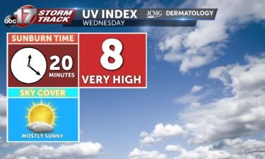
Wednesday’s UV index and pollen tracker
The UV index will be high under mostly sunny skies. Allergen levels remain high through the weekend. Ragweed, Chenopods, and Nettle are the primary allergens.
Continue Reading The UV index will be high under mostly sunny skies. Allergen levels remain high through the weekend. Ragweed, Chenopods, and Nettle are the primary allergens.
Continue Reading
TONIGHT: Today’s cold front teases us with a chance for a sprinkle tonight, ahead of an otherwise dry forecast. Even if we can get a shower or two to develop this evening, dry air may very well dry up any drops before they reach the ground. Expect a dry night, with skies becoming mostly clear
Continue Reading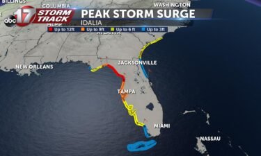
Currently, the state of Florida is preparing for a severe weather event, as Hurricane Idalia is rapidly strengthening and approaching parts of Florida’s Gulf Coast. This specific area is where a Storm Surge Warning is in effect, with some areas seeing chances for Storm Surge inundation of 10-15 feet above ground level, and devastating waves.
Continue Reading
TODAY: I’m tracking temperatures getting up into the mid 80s and partly cloudy skies once a cold front pushes through in the later afternoon. Little to no rain is expected with this front. Winds will be shifting into the NE after this system pushes through, and temperatures will drop into the low 60s overnight. TOMORROW:
Continue Reading
Today: Afternoon highs warm into the mid-80s as winds remain out of the northeast at 5-10 mph. Skies remain partly cloudy. Tonight: Overnight lows cool to the lower 60s with mostly clear sky conditions. Winds remain out of the northwest at 5-10 mph. Extended: The rest of the week sees mostly sunny sky conditions and
Continue Reading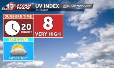
The UV index will be high under partly cloudy skies. Allergen levels remain high through the weekend. Ragweed, Chenopods, and Nettle are the primary allergens.
Continue Reading
TONIGHT: It’s been a mild day with more pleasant weather ahead, before heat returns. This evening, temperatures will fall into the 70s around sunset, with some high clouds overhead and a light variable breeze. TOMORROW: Winds will pick up from the south early Tuesday, before a cold front switches them by mid-morning. This cold front
Continue ReadingCOLUMBIA, Mo. (KMIZ) The Boone County Fire Protection District announced in a Monday press release that 45 members of Missouri Task Force One are heading to Florida. Members are deploying to the Pensacola, Florida, at 6 p.m. Monday ahead of Tropical Storm Idalia hitting the coast, according to the release. Task Force teams from Texas
Continue Reading
Today: The afternoon high rises into the lower 80s with partly cloudy sky conditions. Winds remain out of the northeast at 5-10 mph. Tonight: Overnight lows cool to the lower 60s as winds begin to switch out of the northwest at 5 mph. Skies remain partly cloudy. Extended: A warming trend begins after Thursday as
Continue Reading
TONIGHT: I’m tracking any sort of clouds dissipating overnight, and overall calm conditions for mid-MO. Temperatures will be cooling off into the low 60s, and skies will be staying clear. TOMORROW: I’m tracking another cool start to the morning, and temperatures warming up into the low 80s by mid-afternoon. Skies will be mostly sunny to
Continue Reading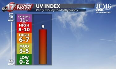
Tomorrow I’m tracking a UV index of 9 as skies are staying partly cloudy to mostly sunny. With these values, it takes 15-25 minutes of exposure to the sun without protection of sunscreen that’s SPF 50 or higher to receive a sunburn. As we stay dry this next week, pollen levels will be staying high.
Continue Reading
TODAY: Clouds and patchy fog will kick off the day with cooler temperatures in the 60s. Cloud cover somewhat clears out by the afternoon with temperatures nearing 80 degrees. A stray shower can’t be ruled out this afternoon near I-44. TOMORROW: Clouds linger into Monday with morning lows in the lower 60s. Highs will once
Continue Reading
TONIGHT: I’m tracking scattered rain and storm chances in the afternoon lasting through the evening, that could bring heavy rainfall to central and southeastern MO with the possibility of localized flooding. Humidity will be increasing through the afternoon and evening hours, with dewpoints and temperatures becoming very close right before sundown. Keeping that in mind,
Continue Reading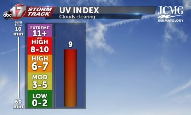
After clouds clear tomorrow morning and early afternoon, mid-MO will be observing a UV index of 9 tomorrow. This means that without protection of sunscreen that’s SPF 50 or higher, it only takes 15-25 minutes of consistent exposure to receive a sunburn. Pollen levels are staying high into next week after rainfall exits mid-MO.
Continue Reading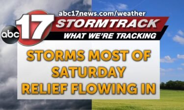
TODAY: A complex of storms will slowly chug eastward through Mid-MO today with the greatest rain chances between noon and 8 p.m. A few isolated high wind gusts are possible, but we’re mostly following relief from the heat today. Temperatures will still quickly warm to near 90 by noon before rain cools us into the
Continue Reading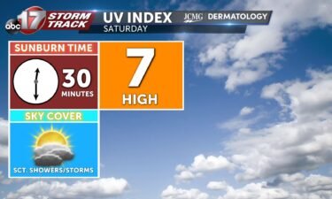
The UV index will be high under partly cloudy skies. Allergen levels remain high through the weekend. Ragweed, Chenopods, and Nettle are the primary allergens.
Continue Reading
With the recent heat, you’ve definitely heard mention of the heat index in forecasts. This metric is a very useful combination of heat and humidity but doesn’t account for many other factors in summertime. Sunshine alone can add up to 15 degrees to the feels-like, and the heat index is based on shaded air temperatures.
Continue Reading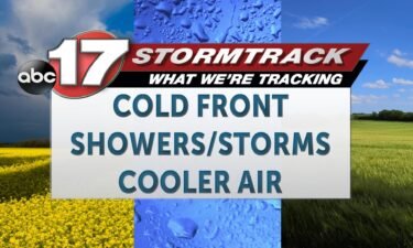
TONIGHT: Isolated storms will be possibility this evening, as our upper level ridge continues to break down. These storms will largely remain sub-severe and pose primarily a lightning risk, but an isolated strong storm cannot be ruled out. Storms that develop will die with or before sunset. The bigger story will be the continued heat.
Continue Reading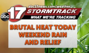
This Afternoon: A Weather Alert Day continues until 8 pm today due to the heat index climbing between 105-110 degrees across the region. Spotty afternoon storms are possible these remain very hit or miss with brief downpours and some gusty winds possible. Tonight: Lows cool to the mid-70s as a cold front moves through Mid-Missouri.
Continue Reading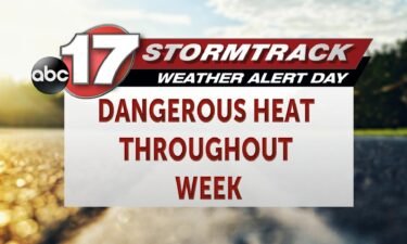
BLOG: The ABC 17 Stormtrack Weather Team has issued a Weather Alert Day lasting from Sunday through Friday evening, as heat index values may span 105-116 throughout the afternoon hours. SETUP: Upper level high pressure will allow this heat to build un-interrupted, and aid in our weekend warm up. This “heat dome” setup may keep
Continue Reading