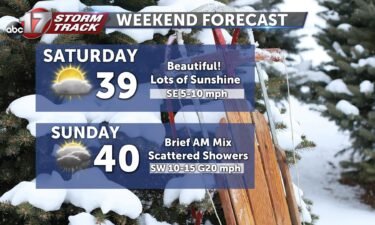
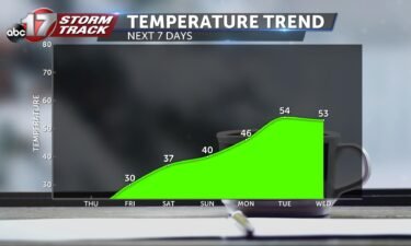
Skip to Content

Daily Forecast

Tracking a cold and cloudy weekend

FRIDAY: Yet another gloomy day is in store as we see a possibility for light flurries to fall this afternoon. Temperatures will top out in the mid-30s with a cool breeze from the north. TONIGHT: That isolated chance of flurries will continue into tonight. No accumulations are anticipated with them as lows bottom out in the middle

Continue Reading

Tracking snowflakes for some today

FRIDAY: Another gloomy day is in store to close out the week. A few flurries will be possible into this afternoon, but shouldn’t be anything more than something to watch. Highs will only top out in the middle 30’s with clouds holding firm. TONIGHT: That isolated chance of flurries will continue into tonight. No accumulations

Continue Reading

Tracking our sunniest day this week

TODAY: High pressure is settling in, calming those winds down this morning. That’s leading to some more fog to deal with to start the day. That looks to clear up around midday, but could linger into the afternoon north of HWY 24. With sunshine returning for the rest of us, temperatures will reach into the middle

Continue Reading

Tracking a calm start to this week

TODAY: That fog we saw this morning will slowly lift into this afternoon, but sunshine will be hard to come by. Highs will reach the upper 30’s to some low 40’s. TONIGHT: Mostly cloudy skies stick around as lows tumble into the middle 20’s. Some patchy fog could be possible, but it won’t be near as widespread

Continue Reading

Tracking a chance for snow today

TODAY: Mostly cloudy throughout the morning with highs in the low 30s. Light snow could begin to the west in the early afternoon and move through the area over the evening. Accumulation is expected to be between a dusting and 1/2″. SUNDAY: Clearer skies and warmer temperatures with highs approaching the upper 30s. EXTENDED: Warmer

Continue Reading