
WATCH: Strong storm moves through Columbia
A strong storm moved through part of Boone County on Tuesday afternoon, dropping heavy rain and hail.
Continue Reading A strong storm moved through part of Boone County on Tuesday afternoon, dropping heavy rain and hail.
Continue Reading
TODAY: Thunderstorms to our west this morning will be in the process of decaying and weakening as they approach our northwestern counties. Thunder and lightning will remain for some time, but these storms should present little threat as they pass by. The cold front driving these storms looks to stall just northwest of the area,
Continue ReadingTonight: Winds continue to remain gusty out of the south at 10-15 mph. Temperatures remain on the warmer side for the overnight low bottoming out just above 70 degrees with partly cloudy skies. Tomorrow: The morning hours begin warm and partly cloudy with temperatures quickly warming back to the 80’s by noon. After 3 PM,
Continue Reading
TODAY: Today is the last entirely dry day of this warm stretch. Yesterday, Columbia just barely cracked 90 degrees, and we’ll have the opportunity to do it again this afternoon. Given a warmer start this morning, and an even more south to southwest oriented wind with similar gustiness at times, temperatures should be able to
Continue Reading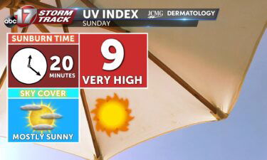
SUNDAY: Partly cloudy and breezy with wind gusts near 25 mph. Highs rise to the upper 80s. MEMORIAL DAY: Fewer clouds with highs approaching 90. A steady southerly breeze helps knock the heat with gusts near 30 mph. EXTENDED: Chances for storms return Tuesday as a cold front is set to impact the region in
Continue ReadingTonight: Temperatures will slowly fall to the mid-60’s tonight with gusty winds out of the south reaching up to 25 mph. Skies remain partly cloudy. Tomorrow: Sunday looks to be partly cloudy with sustained winds out of the south at 20 mph. Highs soar to the upper 80’s leading for potential choppy water on the
Continue Reading
Tonight: Temperatures tonight will slowly fall bottoming out in the mid-50’s. Skies remain mostly clear with winds out of the southeast at 4-8 mph Tomorrow: Skies become partly cloudy Saturday as winds raising out of the south at 8-12 mph lead to warmer temperatures. The afternoon high tops out in the lower 80’s. Extended: Temperatures
Continue Reading
TODAY: Skies will remain cloudy for much of the morning, but clearing is on the way by late morning and early afternoon. For folks near Columbia and eastward, it’s looking like the sun won’t reappear until the afternoon, which would keep temperatures near 70 for a high today. If that timeline speeds up, we may
Continue Reading
TONIGHT: Mostly cloudy with a chance for a spot shower or storm. Lows in the mid-50s. TOMORROW: Clouds decreasing with late day sunshine. Highs in the upper 60s to around 70. EXTENDED: Scattered showers and storms continue to dot the radar this afternoon with cloud cover sticking around, making for another gray evening. Lows fall
Continue ReadingToday: Showers and storms will continue to cycle in Mid-Missouri thanks to a stalled low-pressure system Showers along with the passing of yesterday’s cold front will lead to temperatures hovering around the mid-60’s. Tonight: Showers will persist in Central Missouri weakening after midnight. Temperatures cool to the mid-50’s. Winds remain out of the northwest at
Continue Reading
TODAY: Scattered rain and thunder will remain through the day on Thursday. This wet and gloomy weather keeps temperatures in the 60s this afternoon. Rain will be spotty in nature, so dry time is likely off and on through the day. While some may hear thunder, no severe weather is expected today. TONIGHT: Showers will
Continue Reading
TONIGHT: Mostly cloudy with scattered showers and a few storms. Lows in the upper 50s. TOMORROW: Cloudy with scattered showers and a few storms. Highs in the mid-upper 60s. EXTENDED: The better environment for severe weather for the rest of the afternoon and evening is going to be east of Highway 54. The risk will
Continue ReadingToday: Storms will begin to develop this afternoon to the east of Columbia beginning around 2 PM. All forms of severe risk are on the table including a possible brief spin-up tornado. Thankfully, all risks are on the side of lower probabilities. These storms will continue to build in and push to the east exiting
Continue Reading
TODAY: A Weather Alert Day is in place for the possibility of strong storms in today’s forecast. A cold front will push through today, bringing a line of thunderstorms through mid-Missouri. There is a possibility that storms in this line along the cold front and any that develop out ahead of it, produce hail, damaging
Continue Reading
TONIGHT: Showers and storms likely with lows remaining in the lower 60s. 1-1.5″ of rain is possible with overnight rain. TOMORROW: Plenty of dry time with cloud cover holding on. Isolated strong storms with wind, hail, and the threat of a tornado possible. Highs in the upper 70s. EXTENDED: Showers and a few thunderstorms will
Continue Reading
TODAY: We’re tracking rain slowly making its way into mid-Missouri this morning. This system will have to fight some dry air in place, so showers will take some time to spread over the region. Showers will be very sporadic and far between this morning, with an emphasis on our western counties. East of 63, folks
Continue Reading
TONIGHT: Mostly cloudy with a few showers before daybreak. Lows in the upper 50s. TOMORROW: Mostly cloudy with spot showers and highs in the upper 60s to around 70. Gusty winds up to 25 mph. Widespread rain looks to hold off until around or after sunset. EXTENDED: Clouds have started to roll in with low
Continue Reading
TODAY: Dry weather hangs on a bit longer as Monday is shaping up partly cloudy and cool. Expect temperatures to climb from the low to mid 40s, into the mid to upper 60s. TONIGHT: With added clouds, temperatures don’t fall so far. Most will wake up cloudy and in the 50s Tuesday morning. Showers will
Continue ReadingTonight: Winds remain out of the northeast at 5-10 mph as skies continue to clear. The overnight lows across Central Missouri drops into the mid-40’s. Tomorrow: Skies become partly cloudy as temperatures top out into the upper 60’s stippled by easterly flowing winds. Extended: A deep low-pressure system begins to move in from Oklahoma Monday
Continue Reading
TODAY: Sunday brings a break from the rain, and a return to temperatures more emblematic of early spring. Expect partly cloudy skies, and a high near 65. TONIGHT: Temperatures bottom out in the low 40s again overnight tonight with more clear skies and a light north breeze from high pressure settling to our north. EXTENDED:
Continue Reading