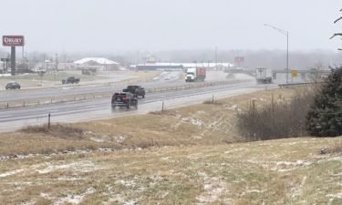
Road crews will return to business as usual for Monday morning commute
Road crews in Mid-Missouri are going back to their normal hours after winter weather created hazards for drivers Saturday.
Continue Reading Road crews in Mid-Missouri are going back to their normal hours after winter weather created hazards for drivers Saturday.
Continue Reading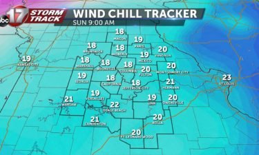
TODAY: Icy road conditions linger after yesterday, especially on untreated roads and roads that are not frequently traveled. Temperatures will begin to warm past freezing today, topping out in the lower 40s this afternoon. Steady winds will keep us with a wind chill factor all day today, and to start our morning, we will have
Continue Reading The Missouri Department of Transportation is warning drivers of flooding and ice-covered roads in parts of central Missouri as a winter storm system continues to move through the area.
Continue Reading
TONIGHT: The heaviest of the snow will move out of mid-Missouri by 8pm. Temperatures will continue falling through the teens this evening as well. Over night lows will fall into the middle teens with wind chills in the single digits by sunrise. SUNDAY: Slick roads will still be possible into the morning hours– especially in untreated
Continue Reading
SYNOPSIS: Snow continues to rotate out of mid-Missouri this evening. Most snowfall will exit our eastern counties by 7pm. Snow will continue to taper off with most of the area seeing 1-3″ total storm accumulation by sundown. In addition to the snowfall, temperatures stay below freezing with winds gusting up to 30 mph at times.
Continue Reading
SATURDAY: We’ll see a transition to a wintry mix, and eventually over to mostly snow. Accumulations are expected to be in the 1-4” range, for a detailed breakdown CHECK OUT THE INSIDER BLOG TONIGHT: We’ll see any lingering flurries taper off tonight as overnight lows fall into the teens. Any untreated roads will still be
Continue Reading
JEFFERSON CITY, Mo. (KMIZ) Jefferson City’s Public Works department is equipped with 24 plow trucks “ready to go” for the forecasted snow. Britt Smith, the Jefferson City Public Works operations division director said when temperatures near that freezing mark, he will have a crew of supervisors out monitoring the roads determining when to bring in
Continue Reading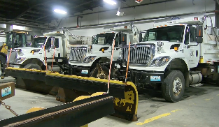
The city of Columbia says plow crews will be on duty starting at 1 a.m. Saturday as heavy rain transitions to ice.
Continue Reading
COLUMBIA, Mo. (KMIZ) A road in southwest Columbia was closed due to flooding amid heavy rainfall Friday night. According to a notification from Boone County Joint Communications, the 3900 block of Grant Lane between Post Oak and Maple Bluff was closed. Officials urged drivers to find an alternate route. The ABC 17 Stormtrack Weather team
Continue Reading
TONIGHT: Heavy rain and thunderstorms. Some could be strong with gusty winds. Flash flooding possible in some areas, especially flood prone zones. Rain transitions to freezing rain after midnight. Lows in the upper 20s. SATURDAY: Wintry mix changes to snow by late morning into early afternoon. Snow accumulation between 1-3″. Snow ends by early evening.
Continue Reading
National Weather Service and National Oceanic and Atmospheric Administration predictions show the Moreau River in Jefferson City swelling to moderate flood stage by Saturday.
Continue Reading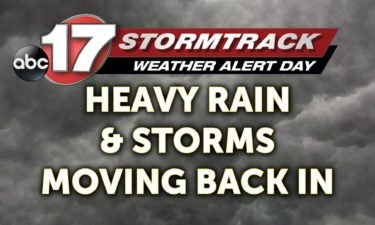
FRIDAY: We are relatively quiet to start the day other than a few showers southeast as temperatures start out mild once again. Showers and storms look to push back in this afternoon. These showers and storms will be heavy, efficient rain producers, which will lead to a flash flooding potential tonight, along with an outside
Continue Reading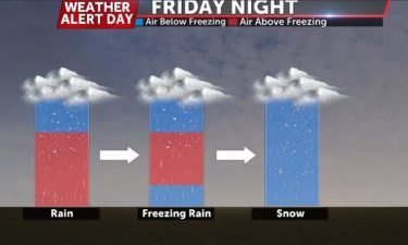
ABC 17 Stormtrack Meteorologist Kevin Schneider explains what is needed for freezing rain to happen.
Continue Reading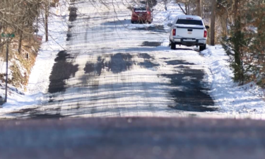
As winter weather moves close to Mid-Missouri, several agencies are gearing up for poor road conditions.
Continue Reading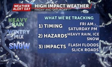
TONIGHT: Mostly cloudy, light showers possible. Lows in the upper 40s. FRIDAY: Mostly dry early with heavy rain and storms increasing across Mid-Missouri by afternoon. Highs in the mid-50s. A few storms may produce gusty winds. Rain amounts range between 2-4″. Flash flooding is possible through Friday night. EXTENDED: As cold air moves in behind
Continue Reading
THURSDAY: We’re starting off with clouds this morning and a southerly breeze, which is why we’ll get back into the upper 50s later this afternoon, even as rain chances move back in later in the day. There’s really no threat with this round, other than to saturate the ground, eventually causing some problems tomorrow. TONIGHT:
Continue Reading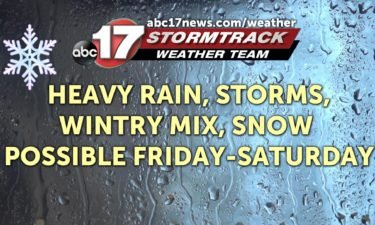
A Weather Alert Day is in effect for Friday and Saturday for the potential of heavy rain and wintry weather. TONIGHT: Increasing clouds and breezy, lows in the mid-40s. THURSDAY: Mostly cloudy, windy, and warm. Rain moves in by late afternoon. Highs in the upper 50s. EXTENDED: Tropical moisture will build in across Mid-Missouri as
Continue Reading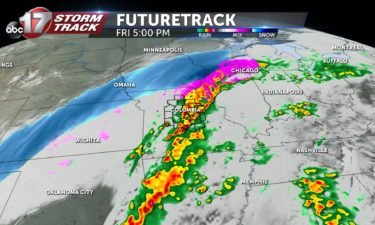
TONIGHT: A warm front will continue lifting north across mid-Missouri overnight. Clouds will build and temperatures will rise into the upper 40s by sunrise. THURSDAY: Thursday starts off dry, mild and cloudy. Rain showers will slowly build into the region after 3pm. Rain could be heavy at times with thunder. Especially following the evening rush. EXTENDED: Rain,
Continue Reading
WEDNESDAY: Temperatures top out in the upper 40s to near 50 once again with more sunshine. We will add in a steady southeast wind with a few gusts getting up around 25 mph. TONIGHT: Those winds keep up overnight as clouds build in. Both of those work together to keep temperatures in the 40s EXTENDED:
Continue Reading
Earlier this afternoon, the Army Corps of Engineers and National Weather Service Meteorologists met to discuss the latest flooding potentials and status on levee repairs. The meeting started out by outlining current conditions within the Missouri River Basin. Precipitation within the last month has been slightly above average across the forecast area. Thankfully, no major
Continue Reading