
Water safety important this upcoming summer
First responders and meteorologists give the warning every spring when heavy rains move through Mid-Missouri – “turn around, don’t drown.”
Continue Reading First responders and meteorologists give the warning every spring when heavy rains move through Mid-Missouri – “turn around, don’t drown.”
Continue Reading
TONIGHT: Most of us have kicked the rain to the curb, with the last of the showers activity on radar keeping south of Jefferson City as of about 4 p.m. Skies will start to clear after the rain exits, but high cloud cover moves in from the west. This won’t introduce any more chances for
Continue Reading
TONIGHT: Rain exits for most by mid-afternoon, with a cold front pushing it completely out of mid-Missouri by 7p.m. or so. Skies will start to clear after the rain exits, but high cloud cover moves in from the west. This won’t introduce any more chances for rain overnight. We’re cooling into the low 40’s early
Continue Reading
Today: Showers begin to creep in from the southwest after 7 AM leading to widespread showers by 9 AM. Temperatures continue to rise as winds filter in from the southwest with gusts up to 25 mph. Friday’s afternoon high tops out into the mid-’60s. Tomorrow: Temperatures cool slightly after the passage of Friday’s cold front
Continue Reading
TONIGHT: Under clear skies Temperatures fall into the low to mid-40’s by early Friday. TOMORROW: Friday morning, clouds return with a chance for showers. Some south of I-70 may hear thunder. Expect highs in the mid-60’s. EXTENDED: Saturday is a touch cooler but boasts more sunshine. Saturday will be the best day for egg hunts and
Continue Reading Today: Winds remained sustained at 10-15 mph with gusts up to 30 mph as sky conditions remain mostly sunny. The afternoon high tops out at 60 degrees. Tonight: Strong winds slowly begin to diminish as sustained winds remain at 8-12 mph. The overnight low crawls to the lower ’40s with partly cloudy skies. Extended: Chances
Continue Reading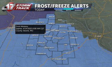
TODAY: Clear skies and near freezing early; a warmup will still get highs to the upper 50s. TOMORROW: Clouds return with a chance for showers. Highs in the mid-50s. EXTENDED: Friday will bring a few more clouds and a weak front that could trigger a couple showers or storms, but no severe threat is expected with
Continue Reading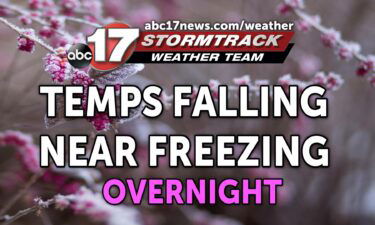
TONIGHT: Clearing skies and much cooler with lows in the lower 30s. TOMORROW: Breezy and mostly sunny with highs in the upper 50s to around 60. EXTENDED: Temperatures have fallen off dramatically after this morning’s storms, and we managed to escape much of the severe threat with a handful of severe storm warnings this morning thanks to more
Continue Reading Today: Lingering storms will slowly push to the east and out of Central Missouri by later this afternoon. Temperatures will gradually fall throughout the next several hour’s thanks to winds returning out of the northwest after the passage of the cold front. Tonight: Temperatures fall to the mid-’30s for tonight’s overnight low with partly cloudy
Continue Reading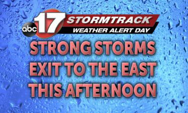
TODAY: This morning, a line of thunderstorms will pass from west to east. This line of storms will gradually weaken, but likely maintain enough strength to generate lightning, thunder, and pockets of heavy rain. A few stronger cells can’t completely be ruled out during the pre-dawn hours, but it looks increasingly unlikely given the environment
Continue Reading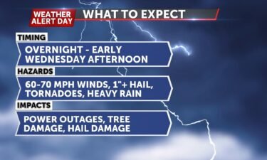
Tuesday Evening Update: A warm front has lifted north of Mid-Missouri bringing clouds more humid air to the region. As the front pushes farther north, temperatures will warm, and skies will start to clear which will boost temperatures even further. Despite temperatures pushing into upper 70s to low 80s and dewpoints in the mid-60’s, a
Continue Reading
TONIGHT: Mostly cloudy with lows in the low 60s. Showers and storms move in well after midnight. Some could bring heavy rain and strong winds. TOMORROW: Scattered storms early, becoming stronger into late morning. Some storms could bring damaging winds, large hail, and a few tornadoes, especially east of Highway 63. Temperatures falling into the
Continue Reading
TODAY: Fog, and light showers are anticipated early this morning as a warm airmass lifts through the region. We will trend drier the rest of the day though, as we pick up winds out of the south. Wind gusts in the 20 to 30 mph range, and sunshine will push temperatures into the 80’s this
Continue Reading
TONIGHT: Mostly cloudy with showers exiting before midnight. Lows in the upper 40s. TUESDAY: Morning clouds with a spot shower possible. Becoming mostly sunny and windy with highs in the lower 80s. EXTENDED: A Weather Alert Day will go into effect late tomorrow night through 5:00 p.m. Wednesday. A significant, multi-day severe weather outbreak is possible across the
Continue Reading
TODAY: Showers and storms at today’s onset will push southeast, and stall. The boundary driving them will settle far enough to our southeast to remove the severe threat for us today, but not far enough to dry us out completely. By 9am, most are dry, especially those north of I-70, and west of I-44. By
Continue Reading Tonight: An approaching cold front pulling in from the northwest will be a driving factor for tonight’s overnight storms. Beginning after 9 pm, isolated storms will begin to form over much of Central Missouri with an increased risk of large hail and strong winds. These storms will continue to lose energy past midnight and become
Continue Reading
THIS AFTERNOON: Mostly sunny and breezy with highs in the upper 70s to around 80. Winds gusting to 35 mph. TONIGHT: Breezy with increasing clouds and a chance of showers and storms ahead of a cold front. A few storms could become strong to severe south of I-70. EXTENDED: We’re warming up as a warm
Continue Reading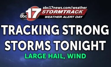
The ABC 17 Stormtrack Weather Team has issued a Weather Alert Day for the threat of severe storms tonight. Large hail and isolated damaging winds will be the main threats. A low pressure system to our northwest is pulling a warm front through the region today, bringing warmer air and gusty winds to Mid-Missouri, along
Continue Reading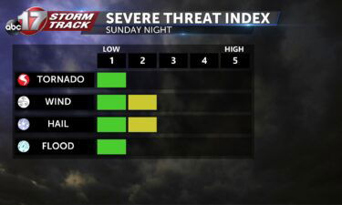
TODAY: Breezy and cloudy with highs in the upper 70s. Storms beginning near dinnertime tonight. A few severe storms are possible with hail and damaging winds as the main concern. TOMORROW: A cold front will settle to our south, keeping highs a little cooler in the mid-60s. More showers and storms are possible throughout the
Continue Reading Tonight: Winds remain out of the southwest at 8-12 mph with mostly clear skies. The overnight low drops to the lower ’40s. Tomorrow: Temperatures soar into the upper ’70s with mostly clear skies making for a beautiful day. Clouds begin to surge in from the west late Sunday afternoon. Extended: Storms begin to pop up
Continue Reading