Weather
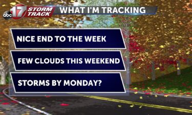
Tracking a mild end to the week
TONIGHT: Mostly clear and mild with lows in the mid-upper 50s. TOMORROW: Partly to mostly sunny with highs in the low 80s. \ EXTENDED: High pressure aloft keeps us warmer than normal through the rest of this week into the weekend as daily high temperatures will reach about 80 degrees, and lows in the upper
Continue Reading
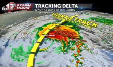
Tracking the impacts of Hurricane Delta through the weekend
Hurricane Delta has made landfall just to the south of Cancun this morning near Puerto Morelos as a category 2 storm. It weakened this morning to 110 mph winds as it bore down on the Yucatan Peninsula. An observation site in Cancun reported 84 mph sustained winds with gusts to 104 mph. As of 4:00
Continue ReadingMizzou, LSU game leads to staffing shortage; could boost economy
MU officially confirmed Wednesday that Saturday’s game moved to Columbia because of Hurricane Delta.
Continue Reading
Wednesday warmup! Temperatures near 90 this afternoon
THIS AFTERNOON: You’ll feel it out the door this afternoon– more like late-May than early-October! Temperatures will rise into the mid-80s across many areas. Our southern counties may even make a stretch into the upper 80s to near 90. Expect lots of sunshine. TONIGHT: Quiet and comfortable overnight with lows falling into the mid to upper 50’s.
Continue Reading
Tracking a toasty afternoon
WEDNESDAY: Temperatures keep up the warming trend this afternoon. Highs will make it into the middle 80’s under full sunshine once again. Humidity won’t get out of hand, but definitely more of a Summer-like feel today. TONIGHT: Quiet and comfortable overnight with lows falling into the mid to upper 50’s. EXTENDED: The introduction of clouds
Continue Reading
Jefferson City Council approves demolition for building damaged by tornado
The Jefferson City Council unanimously approved a demolition project for a building on East Capitol Avenue during its Monday night meeting.
Continue Reading
Tracking summer-like temperatures Wednesday
TONIGHT: Mostly clear and mild. Lows in the mid-50s. TOMORROW: Mostly sunny and warm with highs in the mid-80s. EXTENDED: High pressure builds overhead on Wednesday, giving us our warmest day of the week as highs skyrocket into the mid-80s, more than 10 degrees warmer than normal. The rest of the week will feature afternoon
Continue Reading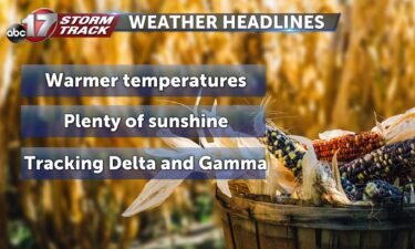
Tracking trouble in the tropics
TUESDAY: We’ll start off noticeably warmer this morning, and that will help us get into the upper 70’s this afternoon. It’ll be another day with just about wall-to-wall sunshine and a westerly breeze keeping things from feeling hot. TONIGHT: Mostly clear to end the day, which typically means cool nights. Winds out of the southwest will keep
Continue Reading
Tracking another bright afternoon
TUESDAY: We’ll start off noticeably warmer this morning, and that will help us get into the upper 70’s this afternoon. It’ll be another day with just about wall-to-wall sunshine and a westerly breeze keeping things from feeling hot. TONIGHT: Mostly clear to end the day, which typically means cool nights. Winds out of the southwest
Continue Reading
Tracking much warmer weather this week, remaining quiet
TONIGHT: Mostly clear and breezy with lows in the low 50s. TOMORROW: Mostly sunny with a few passing clouds. Highs in the upper 70s. EXTENDED: Upper level high pressure takes hold of our sensible weather this week in Mid-Missouri as south winds push warmer air across the region. A weak disturbance tries to move through
Continue Reading
Tracking another frosty start
MONDAY: After a cold start this morning, temperatures will recover into the upper 60’s this afternoon. Wall-to-wall sunshine and a breeze out of the south gusting to 20 mph at times will get the job done today. TONIGHT: Those southerly winds hang on tonight, but won’t be nearly as strong. But they will help keep
Continue Reading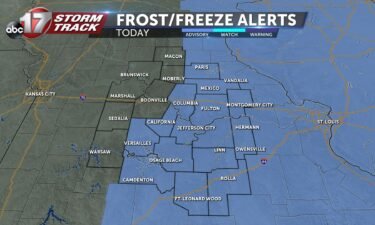
Tracking the potential for frost overnight
TONIGHT: Overnight, temperatures will drop into the mid to upper 30s, giving us the potential to see frost. The National Weather Service out of St. Louis has issued a frost advisory that continues into tomorrow morning at 8 AM. Cover those plants and incorporate a few extra minutes to scrape your windshield tomorrow morning! TOMORROW:
Continue Reading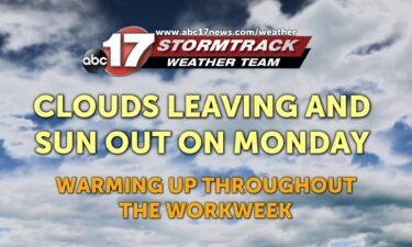
Clouds clearing out and a warmup on the way
TODAY: Those cloudy skies from yesterday are going to persist for much of the morning and afternoon. The sun will finally try to peek out as the evening approaches. This will keep us cool for most of the day as high temperatures stick around 60 degrees. MONDAY: The sunshine will make a big return as
Continue Reading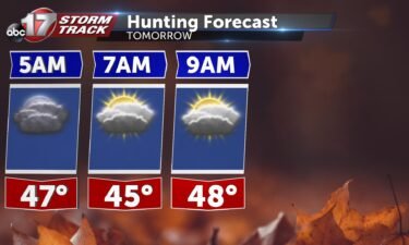
Tracking the end to our rain chances for the week
TONIGHT: A few spot showers on the back end of the system that brought us rain earlier today are possible later this evening, but it won’t be a washout. Temperatures will fall into the mid 40s as we head into Sunday. TOMORROW: Waking up, cloud cover will continue which will cause us to be slow
Continue Reading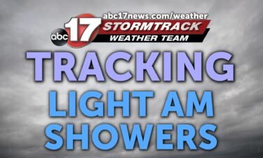
Tracking AM showers
TODAY: Showers will move in throughout the early hours today. These storms will be relatively weak and drop less than an inch of rain throughout the morning. Conditions clear up in the afternoon as the temperature approaches the upper 50s. Clouds will stick around all day. SUNDAY: Clouds begin clearing out in the afternoon and
Continue Reading
Tracking showers to start the weekend
TONIGHT: Increasing clouds and cool with a chance of showers after midnight. Lows in the low to mid-40s. TOMORROW: Cloudy with scattered showers through late afternoon into early evening. Highs in the upper 50s to around 60. Rain amounts between 0.1″ to 0.25″. EXTENDED: The disturbance responsible for Saturday’s rain will exit east on Sunday,
Continue Reading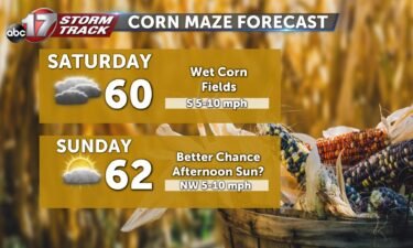
Tracking rain chances to start out the weekend
TODAY: Temperatures will climb out of the 30’s and into the low 60’s for highs this afternoon. Winds won’t be nearly as breezy as they have been, but still out of the northwest at about 5-10 mph. TONIGHT: Clouds will be on the increase this evening and continue overnight. Rain looks to make a return after midnight
Continue Reading
Tracking a cold start, with rain around the corner
FRIDAY: Many of us are getting off to one of the coolest starts since May so you’ll want to grab the jackets out the door. Temperatures will climb out of the 30’s and into the low 60’s for highs this afternoon. Winds won’t be nearly as breezy as they have been, but still out of
Continue Reading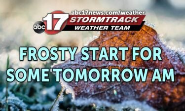
Tracking a frigid fall Friday morning
TONIGHT: Mostly clear and cold with lows falling into the upper 30s to low 40s. Patchy frost possible for areas north of Highway 36. TOMORROW: Mostly sunny and chilly with highs near 60. Not as breezy with clouds increasing by evening. EXTENDED: A weak disturbance riding along a cold front to our west will bring
Continue Reading