
Red Flag Warning takes effect at noon
The National Weather Service has issued a red flag warning for much of the viewing area that will be in effect until 6 p.m. Wednesday.
Continue Reading The National Weather Service has issued a red flag warning for much of the viewing area that will be in effect until 6 p.m. Wednesday.
Continue Reading
TONIGHT: Mostly clear and cool as winds ease. Lows in the upper 40s to around 50. TOMORROW: Mostly sunny and breezy. Fire weather conditions possible with dry soils and gusty winds up to 35 mph. Avoid outdoor burning. Highs in the lower 80s. EXTENDED: Another powerful cold front will plow through the area on Wednesday
Continue Reading
>More information on tonight’s opposition of Mars can be found here<
Continue Reading
TUESDAY: We’re off to a much cooler start this morning, but we’ll turn things around this afternoon. Highs will reach the upper 70’s with winds swinging out of the southwest. Some gusts will get up around 25 mph later today as that sunshine sticks around. TONIGHT: We’ll hang onto mostly clear skies overnight with temperatures
Continue Reading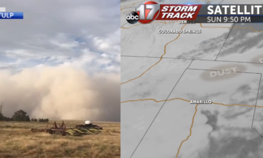
Strong front carried dust hundred of miles While most of the dust had thinned out by the time it had reached mid-Missouri, enough of it carried that you may notice a thin film of dust and grime on your car today. Infrared satellite picked up on the thick cloud of dust traveling across the southern
Continue Reading
TONIGHT: Mostly clear and cool with winds dying down. Lows in the mid-upper 40s. TOMORROW: Mostly sunny and breezy with highs in the upper 70s. EXTENDED: It will be a warm start to the week as winds shift back to the south on Tuesday, sending temperatures into the upper 70s and lower 80s through Wednesday.
Continue Reading
THIS AFTERNOON: Gusty winds behind a strong fall cool front will continue this afternoon. Winds upwards of 30-35 mph are possible. Expect a lot less humidity and comfortable temperatures through the day! TONIGHT: Winds back off tonight with mostly clear skies overhead. Temperatures will cool off into the upper 40’s. EXTENDED: Those winds turn more southwesterly tomorrow, but
Continue Reading
MONDAY: Winds will pick up this morning as a front arrives. Gusts will reach 30-35 mph at times as those winds swing out of the northwest behind the front. Temperatures will be held up this afternoon in the upper 60’s to some low 70’s, despite plenty of sunshine. TONIGHT: Winds back off tonight with mostly
Continue Reading
TONIGHT: Temperatures tonight will be comfortable until early tomorrow morning when a cold front pushes through. As the front approaches, winds will pick up into the ~20 mph mark, so tie down those trashcans before heading off to bed tonight! MONDAY: There’s a small chance for some AM showers as that cold front makes it’s
Continue Reading
TODAY: We’ll be seeing almost the same conditions as yesterday with temperatures today again reaching into the low 80s. Some humidity is hanging in the air and that’ll have us feeling a little warmer but it will be exiting the area soon. MONDAY: A front moving through in the early morning will begin our workweek cooldown. There’s
Continue Reading
TONIGHT: Conditions will be calm and cool tonight as temperatures fall into the lower 60s. TOMORROW: Sunday will be our last warm day in the 80s for a while with some humidity playing into the day. Clouds may flit across the sky, but we largely will be sunny. EXTENDED: After all of the warmth and humidity
Continue Reading
TODAY: Expect temperatures to rise quickly today as skies stay mostly clear. By kickoff for the game today we’ll be in the upper 70s. Some humidity has moved into the area so it’ll feel a little warmer than it actually is. High temp in the afternoon will top out in the low 80s and we’ll feel
Continue Reading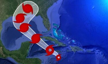
Watch live webcams from the area affected by Hurricane Delta.
Continue Reading
TONIGHT: A few clouds are expected into this evening with warm & slightly muggy weather holding on. Expect temperatures in the upper 70s through sunset. We’ll drop to near 60 by tomorrow morning. THIS WEEKEND: Looks like a great weekend for football and being outside! Enjoy the summer-like weather with low to mid 80s Saturday and
Continue Reading
FRIDAY: Another quiet afternoon expected today. Just about the only difference will be the southwesterly breeze. Those gusts could reach 20-25 mph later today, but highs will still top out in the low 80’s again. A few clouds will slide through later this afternoon, but just look like a brief interruption of sunshine. TONIGHT: Those
Continue Reading
TONIGHT: Mostly clear and mild with lows near 60. TOMORROW: Breezy and warm with sunshine. Highs in the low 80s. EXTENDED: Warmer than average temperatures stick around into the weekend despite some cloud cover on Saturday as the remnants of Hurricane Delta pass to our southeast. Temperatures will remain in the low 80s both Saturday
Continue Reading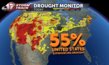
Interactive Drought Map Below https://droughtmonitor.unl.edu/
Continue Reading
THIS AFTERNOON: It will be another warm and muggy October afternoon across mid-Missouri. Expect a few more clouds today as clouds from Hurricane Delta continue to stream in. TONIGHT: The quiet weather sticks around tonight with lows backing off into the upper 50’s under mostly clear skies. EXTENDED: Another warm afternoon will get us to the weekend on
Continue Reading
THURSDAY: It doesn’t look to be quite as warm as we got yesterday. Temperatures will top out in the low 80’s with more sunshine to go around. A few more clouds will move in than we’ve seen, but looks like we’ll stay dry again with any sprinkles staying south. TONIGHT: The quiet weather sticks around
Continue Reading