Skip to Content

Daily Forecast

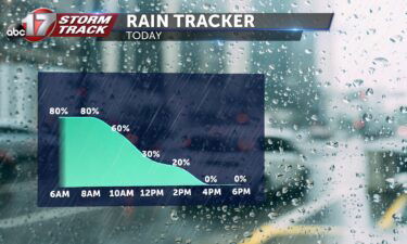
Tracking rain chances through the week

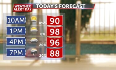
TODAY: After a brief stint of rainfall on Sunday, a better chance for rain comes area wide with scattered showers and storms throughout the day. A stationary boundary has storms ongoing near the lake and I-44 this morning. Rain chances will lift to the north through the morning. By this afternoon, a better chance for

Continue Reading

Tracking dangerous heat

Today: Temperatures will continue to surge into the triple digits with the heat index reaching 105 degrees across many areas. Winds remain out of the south at 5-10 mph. Skies remain mostly sunny with chances of isolated afternoon showers/ storms near the highway 44 region. Storms will remain short lived and very spotty. Tonight: Skies

Continue Reading

Tracking a steady warm up this week

TODAY: Monday marks the return of a sunnier forecast, after weekend rain. After some picked up more than half an inch, little rain looks to populate the next 7 days. High pressure keeps sunshine in the forecast Monday, with a high near 90. TONIGHT: High pressure is slowly exiting overnight, but it keeps conditions ripe

Continue Reading

Tracking scattered showers and storms becoming widespread by Sunday

Tonight: Scattered showers and storms will continue throughout Saturday night as temperatures cool to the lower 70’s. Lightning and some strong downpours will be possible. Tomorrow: Showers and storms will become more widespread by Sunday morning aiding in diminishing short term drought conditions. Areas east of highway 63 will see greatest rainfall totals between 0.5″-1″.

Continue Reading