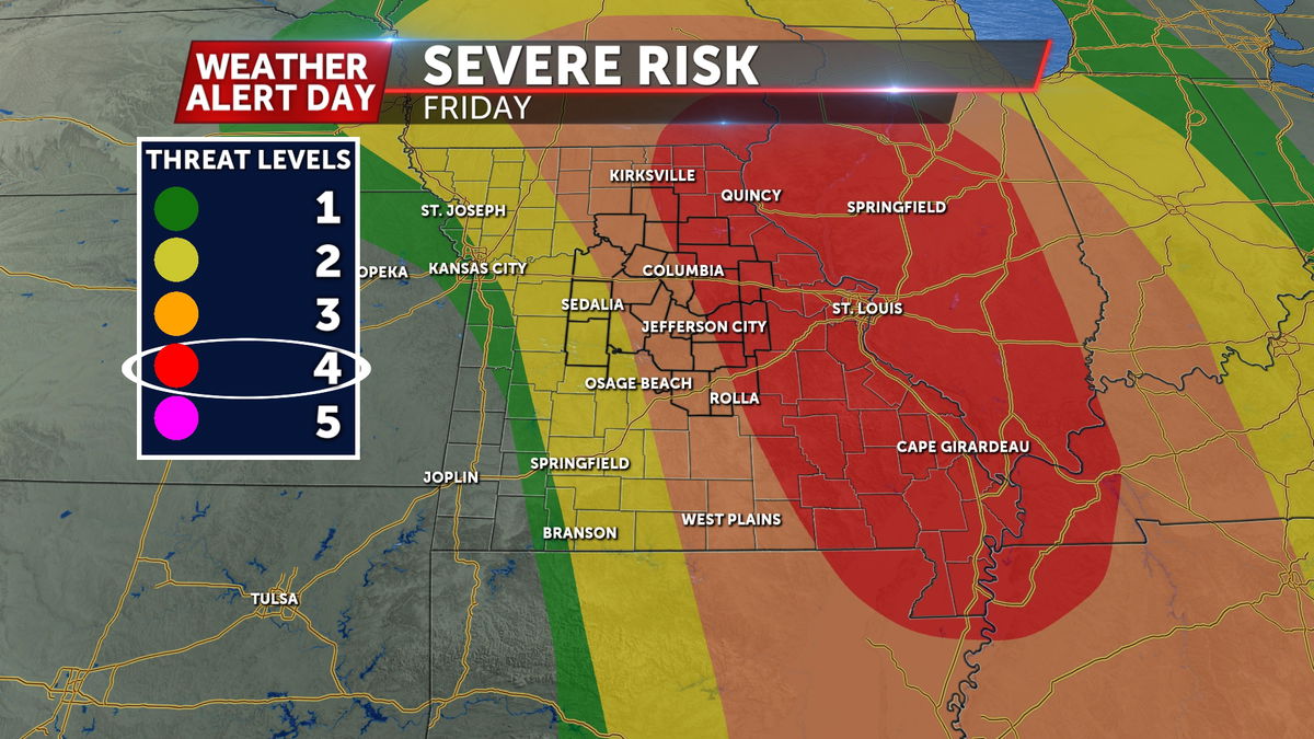
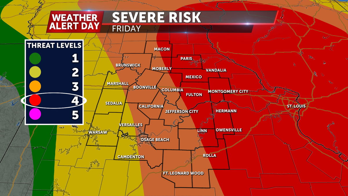
WEATHER ALERT DAY: Friday afternoon storms intensify and move quickly, bring significant damaging wind threat
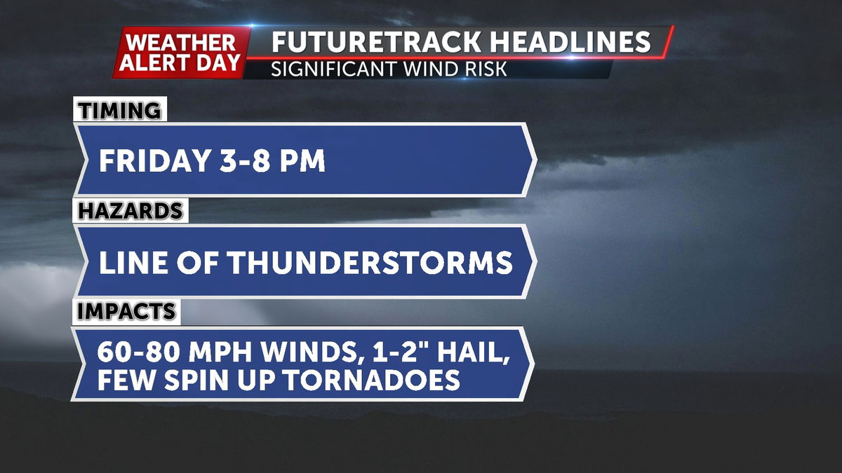
The weather team is issuing an ABC 17 Stormtrack Weather Alert Day for Friday, March 14th. We are tracking a system that is poised to threaten significant damaging winds, large to very large hail, and a few tornadoes from 3-8 p.m.
SETUP:
A deep area of low pressure, rivaling that of our last ABC17 Stormtrack Weather Alert Day we issued. That one was for wind, whereas this go-around will bring a chance for severe storms.
This area of low pressure will do it's best to foster an environment for severe storms by pulling moisture northward from the gulf, and blowing in plenty of warmth under sunny skies. The latter will bolster pockets of modest instability in mid-Missouri and places eastward by the peak heating hours of the day.
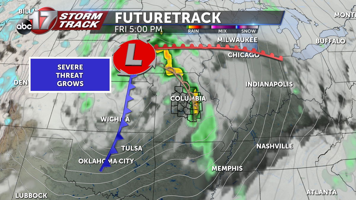
It is now more clear that we will be able to reach more impressive numbers. Despite strong winds trying to pull in moisture from the south, available moisture has been thought of as a possible limiting factor on our severe threat. It still could be, but at this point, confidence is increasing that a robust system with abundant forcing from and with strong wind support through the atmosphere will be able to make use of what storm environment is available. On a high end, we'll get development west of us, earlier in the event. On the lower end of the spectrum, storms could struggle to initiate until the dry line gets into mid-Missouri, but when they likely do, they could become strong very quickly.
TIMING:
The greatest environment for these storms looks to peak during the late afternoon and early evening. This system's timing places that environment along and east of HWY 63.
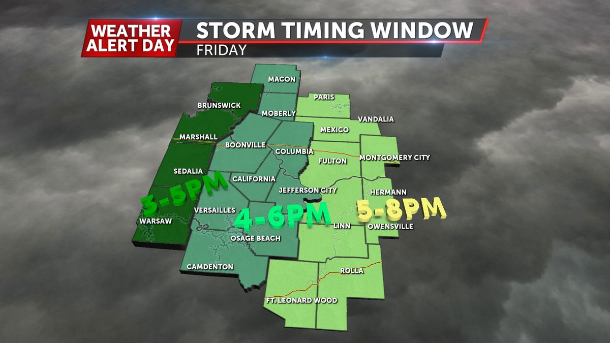
Prior to this, storms will likely fire in the early afternoon along a dry line in eastern Kansas and western Missouri. This will begin a cluster of storms that will likely form into a line of thunderstorms, or a Quasi-linear Convective System - QLCS for short. This line will march across the region from 3 p.m. in the west to an exit in the east by 8 p.m.
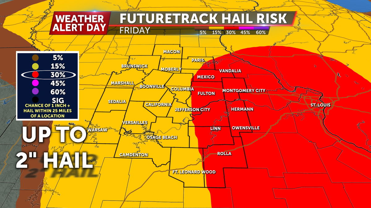
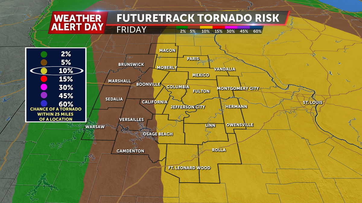
HAZARDS:
This QLCS will have abundant mechanical support in the atmosphere to drive a wind threat. The low level jet, which is a stream of lower atmosphere wind just above the surface, will be racing along from the south to the north at a pace of 50-60+kts (58-70mph). This will support a severe (58mph) to a possible but isolated significant severe (75mph) wind threat.
QLCS events like these often produce what we would consider weak spin-up tornadoes. This is where rotation develops in the line of storms because of wind speed differences through the line. This may result in these QLCS type tornadoes, but a large scale strong tornado risk does not appear likely with this event in mid-Missouri.
Some storms may also produce a risk for large hail, with 1 inch or quarter size the upper limit of current expectations.
IMPACTS:

Don't get caught off guard! With Friday afternoon being a warm start to the weekend, our concern is that a significant amount of the community may be out enjoying a beautiful, albeit windy evening when storms roll in. Pay close attention to the weather Friday afternoon and evening, and share this with those especially those with outdoor plans. It may take storms a while to cross the region from west to east, but individual storms within the greater line will move from southwest to northeast very quickly.
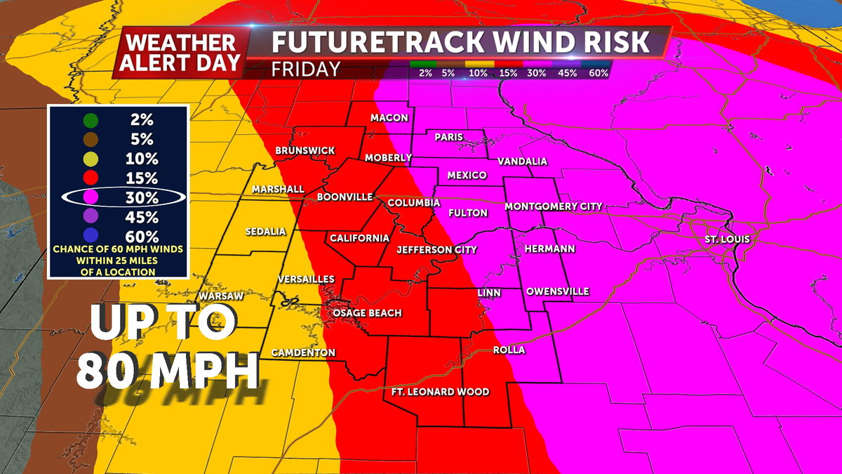
The severe wind threat is our greatest concern, which would be dangerous for those stuck outside. Damage to structures is possible, especially those that are less sturdy like barns, sheds, or other outbuildings. Power outages are also possible with damage expected to power infrastructure in the strongest winds.
In the event of a severe thunderstorm, take shelter in a sturdy building away from windows. In the event of a tornado warning, get to the lowest level of a sturdy building (a basement if possible), and to the innermost room, away from exterior walls.
