Weather

Weather calming down rest of the week, warm into weekend
THIS AFTERNOON: It’s a pretty decent day out today, temperatures are expected in the mid 80s over the next couple of hours. Should be a good evening to get outside! TONIGHT: We’re looking dry tonight, with a few passing clouds. Lows will fall into the middle 60’s. EXTENDED: Temperatures look a touch warmer tomorrow, into the mid
Continue Reading
Tracking some slight rain chances today
WEDNESDAY: A frontal boundary draped to our south will keep most of the rain chances with it today. That would mean folks around the I-44 corridor see the best chance of a few showers throughout the day. Most of us, on the other hand, look to stay dry today. We’ll be fighting out of the
Continue Reading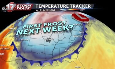
FALL BLAST: Next week to bring jacket-weather back to mid-Missouri
2020 continues to zip right on by… Yeah, pretty crazy to think we’re already talking about truly fall-like air. It’s looking more and more likely we’re be in the thick of it by this time next week! And if we’re going to talk technicalities, the fall season has already begun! Meteorologists use September 1st to
Continue Reading
Tracking lower rain chances, cool down by the weekend
TONIGHT: Partly cloudy with lows in the mid-upper 60s. Spotty showers possible early. Fog developing late into Wednesday morning. TOMORROW: Partly to mostly cloudy with a slight chance for showers and possibly a thunderstorm south of I-70. Highs in the mid-80s. EXTENDED: The cold front responsible for this week’s rain will slowly move south over
Continue Reading
Gloomy weather continues this afternoon
THIS AFTERNOON: Clouds will try to hold on for this afternoon, but some peeks of sunshine here and there are expected as well. A few more rain showers are possible too. The highest chance will be to the southeast of Columbia. Temperatures will behave, expect 70s for most of the rest of the day. TONIGHT: Still can’t
Continue Reading
Tracking another stormy start
TUESDAY: More storms to start us off this morning. Expect most of these to remain below severe limits, but some more heavy downpours will make driving tough. Coverage starts to thin out this afternoon and evening with highs in the upper 70’s and low 80’s. TONIGHT: Still can’t rule out a stray storm or two
Continue Reading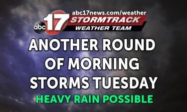
Tracking another round of storms Tuesday morning
TONIGHT: Spotty storms possible, mostly cloudy with patchy fog developing. Lows in the upper 60s. TOMORROW: Widespread showers and storms early. Some storms could bring heavy rain and frequent lightning, but the severe weather threat is much lower than Monday. Rain amounts will range from 0.5″ to 1″. Storms diminish southeast by late afternoon. Highs
Continue Reading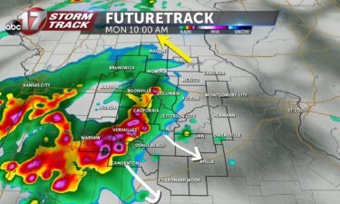
Storms tapering off this afternoon
MONDAY: A complex of showers and thunderstorms are possible this morning. Some storms could contain strong wind gusts or small hail. The most widespread activity will be along and south of I-70… especially if you close to the Lake of the Ozarks. The main timeframe for storms will be between 9:00am-1:00pm. Temperatures will be mild, in
Continue Reading
Rain chances increasing for the workweek
TODAY: Mid-Missouri won’t see quite as much rain as yesterday with some spot showers possible in the afternoon. It will remain cloudy most of the day to help keep us cool. The high temperature is expected to reach 80 degrees. MONDAY: Rain moves back into the forecast with some morning showers possible throughout some of the
Continue Reading
Tracking cooler and drier conditions
TONIGHT: Conditions will dry out as we close out our Saturday, and temperatures will fall into the mid 60s. Tomorrow: Sunday is expected to stay on the drier side with only a few spot showers being possible in the afternoon. Some stubborn clouds will likely hang out through the majority of the day. Temperatures will
Continue Reading
Tracking storms and cooler temps
TODAY: A cold front is making its way through Missouri today, bringing with it the potential for rain and cooler temperatures. Rain chances looking to stay low for much of the morning; however, our southern counties will see some storms throughout the afternoon. The high temperature for today should stick around 81. SUNDAY: Conditions calm down a
Continue Reading
Cooldown leads to rain chances this weekend
TONIGHT: Clouds will increase again overnight with temperatures falling to near 70. A few showers/storms are possible by tomorrow morning. SATURDAY: A complex of showers looks to roll through the southern half of mid-Missouri between sunrise and lunch tomorrow. Those from Jeff City to the Lake will want the umbrella in the morning. We will get
Continue Reading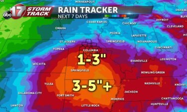
Tracking heat and plentiful rain chances
TODAY: The remnants of tropical storm Laura will track across far southeast Missouri, keeping cloud cover over our eastern areas. A few of our western counties may see some sunshine later in the day. As Laura’s remains push out of southeastern Missouri, we could see a few spot showers or storms, especially in our far
Continue Reading
Tracking spot storms tomorrow, much cooler weekend
TONIGHT: Mostly cloudy and muggy with lows in the low 70s. Rain chances stay fairly slim. TOMORROW: The remnants of tropical storm Laura will track across far southeast Missouri, keeping cloud cover over our area. Some of the outer bands of this system will bring scattered showers and a few thunderstorms for places east of
Continue Reading
Tracking slight chances of storms through the weekend
THIS AFTERNOON: A few storms are occurring south of HWY 50 this afternoon. For the most part, that’s where the activity is going to tend to hang around today. Most of us are going to see increasing cloud cover through the rest of the afternoon, which should keep temperatures in the mid to upper 80s. TONIGHT: Rain
Continue Reading
Tracking more warm weather this afternoon
THURSDAY: It’s looking like more of the same this afternoon. Highs will once again reach the low 90’s and feel like nearly 100 this afternoon. That is where we don’t pick up a stray storm or two later today. Most locations will stay dry, but those south of I-70 stand the best chance at picking up
Continue Reading
Tracking continued heat, effects of Hurricane Laura
TONIGHT: Partly cloudy and mild with lows in the low 70s. Staying muggy. TOMORROW: Increasing clouds, slight chance of a few showers or storms. Highs in the upper 80s to around 90 with a heat index between 95-96. EXTENDED: Clouds begin to increase Thursday and Friday ahead of what’s left of Hurricane Laura, which is
Continue Reading

Tracking fleeting warm weather
WEDNESDAY: Another toasty afternoon on tap once again. Just about the only saving grace we might find will be a spot shower. Most of that activity will once again be around the I-44 corridor, however. The rest of us will see highs in the low 90’s with a heat index in the upper 90’s. TONIGHT:
Continue Reading