
GALLERY: Storms cause flash flooding, damage in Jefferson City
The Jefferson City Fire Department responded to at least 25 incident Sunday as a severe thunderstorm swept through the area.
Continue Reading The Jefferson City Fire Department responded to at least 25 incident Sunday as a severe thunderstorm swept through the area.
Continue Reading
A line of severe thunderstorms blossomed across the Highway 50 corridor this evening. It brought extremely heavy rainfall to Moniteau and Cole Counties. Flooding was reported on several roadways near creeks and streams in Jefferson City. A flash flood warning remains in effect until 11:15pm for Moniteau, Cole and Southern Callaway Counties. Radar indicated rainfall
Continue Reading
TONIGHT: A flash flood watch is in effect for several mid-Missouri counties until 1:00 am. The main threat looks to be between HWY 50 and I-70 and for cities along and near the Missouri river. Avoid crossing flooding roadways into the evening! Storms will continue past midnight before tapering off by sunrise tomorrow MONDAY: While
Continue Reading
The ABC 17 Stormtrack Weather Team has issued a Weather Alert Day in effect today through tonight for the potential of dangerous heat. A Heat Advisory is in effect for the entire viewing area for heat indices between 105-107 on Sunday. The jet stream will continue to lift north this week, with high pressure building
Continue Reading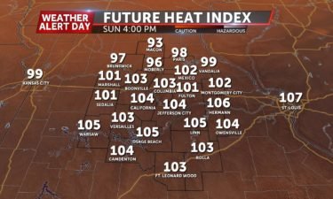
TODAY: Today will largely mirror yesterday’s temperatures, but we’re also tracking rain chances for the day. A cold front will be approaching mid-Missouri, and as it settles into the area, we will start to see storms developing along that I-70 corridor. The first round of storms will begin in the afternoon and last until after dinner,
Continue Reading
TONIGHT: Warm & Muggy. Temperatures fall into the mid-70s. SUNDAY: We’re off to another warm day tomorrow. Expect a few more clouds as a cold front approaches into the afternoon. Storms are possible after 5pm… until then expect low to mid 90s and heat index values above 100º. EXTENDED: Storms are expected to become more numerous Sunday
Continue Reading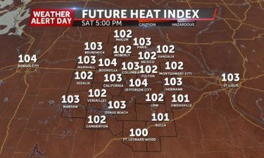
SATURDAY: Today will be defined by the intense heat and humidity that we will be seeing. Expect temperatures between 93-96 degrees with feels like temperatures around 105 degrees. Partly cloudy skies will dominate, but rain chances are minimal. TONIGHT: This evening will not cool down all too well as lows only fall into the mid 70s.
Continue Reading
TONIGHT: It will be warm and muggy with temperatures only dropping to about 75. SATURDAY: It’s another hot and steamy day tomorrow. We’ll have to watch out for a stray storm or two, especially north of I-70 and an outflow boundary from storms up north ripples toward mid-Missouri. Most of us will likely stay dry. Expect
Continue Reading
FRIDAY: Temperatures will warm up a few degrees this afternoon into the low 90’s. With the return of some humid conditions, heat indices will reach the century mark in a few spots. A stray storm or two will be possible later this afternoon, primarily south of I-70. TONIGHT: Any activity should fizzle with the loss
Continue Reading
TONIGHT: Partly cloudy and mild with lows in the low 70s. TOMORROW: Partly sunny with increasing humidity. Rain chances mainly stay south, but highs reach the low 90s with a heat index between 98-101 degrees as a warm front lifts north over the area. EXTENDED: The front stays to our north along with the jet
Continue Reading THIS AFTERNOON: Not all that bad out there today. Think temperatures in the mid to upper 80s with tolerable humidity. TONIGHT: Mostly clear and mild. Lows fall into the low 70s. EXTENDED: Those southerly winds will return with a warm front lifting back north, along with the Summer heat. Temperatures look to top out in the low
Continue Reading
THURSDAY: It’s fairly settled moving into this afternoon. We’ll enjoy some sunshine, which will help temperatures into the upper 80’s and low 90’s. Feels like temperatures will be held in check with a northerly breeze throughout the day. TONIGHT: Winds will try to turn a little more southerly overnight. Lows will still get back into
Continue Reading
TONIGHT: Storms end, with clouds sticking around overnight. Temperatures hold around 70 through dawn. TOMORROW: Partly to mostly cloudy and a bit less humid, with lower heat indices in the low 90s. Highs get into the upper 80s. Any rain chances will be tied to the front that will be draped across southern Missouri. EXTENDED:
Continue Reading
You the NASA teleconference that has more information on viewing NEOWISE by clicking here.
Continue Reading
People who need a break from the heat can choose from four cooling centers in Columbia, but a fifth center is closed because of the COVID-19 pandemic.
Continue Reading
WEDNESDAY: Showers and thunderstorms are moving in from the north this morning. How far south these make it will determine who might see some stronger storms this afternoon. Current thinking is that anywhere from the I-70 corridor and south will be under the gun to redevelop storms after midday with all severe threats in play.
Continue Reading
TONIGHT: Partly cloudy and muggy with lows in the low 70s. A line of showers and thunderstorms is expected to move in well after midnight, bringing potentially periods of heavy rain and gusty winds. TOMORROW: Morning storms will keep temperatures a bit cooler, and mainly stay north of I-70 through midday. Another round of storms
Continue Reading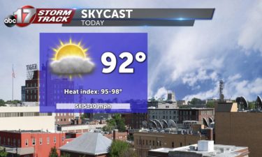
TUESDAY: That warmth finally sets in as we get into this afternoon as highs will push into the low to mid 90’s with a heat index threatening the triple-digits. We’ll see a few more clouds than we’ve had these past few days, but conditions will remain calm. TONIGHT: Storm chances return late tonight. Depending on how organized
Continue Reading
TUESDAY: We start the warming trend this afternoon. Highs will push into the low to mid 90’s with a heat index threatening the triple-digits. A batch of showers out west will throw some more cloud cover our direction, but we’ll stay quiet other than that today. TONIGHT: Storm chances return late tonight, however. Timing’s a
Continue Reading
TONIGHT: Mostly clear and comfortable with lows in the upper 60s to around 70. TOMORROW: Intense heat begins with dew points rising in to the low 70s, getting us to the upper 90s to around 100 for the heat index. Expect a breezy afternoon with gusts up to 20 mph. Storm chances will be limited
Continue Reading