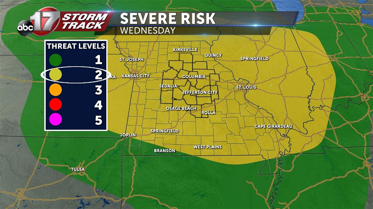
Weather Alert Day: Strong storms possible Wednesday
UPDATE
WEDNESDAY NIGHT UPDATE
Confidence is increasing this morning in a severe round of storms after 9 p.m. Storms will generally redevelop after 7 p.m. along a boundary in the atmosphere left by activity from earlier in the day. This boundary will roughly trace I-70, but understand chances for development will fall on both sides of the interstate. While we will have to watch development here in mid-Missouri for severe potential, the focus will be on activity in eastern Kansas, and it's potential for upscale growth as it travels eastward into mid-Missouri. Latest estimates have this element arriving in our western counties between 10 p.m. and 11 p.m. These storms will continue into the 2 a.m - 3 a.m. time frame before exiting mid-Missouri to the south and east.


TUESDAY UPDATE
As of Tuesday night, it is becoming more clear that we will have two main rounds. One in the morning, that may consist of some sub-rounds. While a strong storm can't be ruled out here, activity that arrives in the north in the morning should be on a weakening trend. Another round later in the evening and overnight will have a better chance at bringing chances for strong to severe storms capable of damaging winds. The best chance for severe weather will likely come in the south, where the atmosphere will be less worked over compared to areas north of I-70.
SETUP

Mid-Missouri is sandwiched between an upper level low pressure to the north, and high pressure to the south. This has the jet stream bringing stout northwest flow through the region; not just today, but through the rest of the week. A symptom of this, is an almost daily dose of what we call "shortwaves". These are small disturbances in the upper level flow that can create thunderstorms if other ingredients are also present in the atmosphere.

As you might imagine, we have those ingredients present on Wednesday; it's why we're writing this blog! This shortwave we just talked about is going to likely trigger storms in Nebraska and Iowa where we have moisture and instability, Tuesday night. These storms will likely grow and upscale themselves into a complex of storms, or mesoscale convective complex (MCS for short). This shortwave/MCS combination can be a tricky feature to forecast, but they tend to grow and travel along the storm energy gradient. This will likely bring the line of storms southeast into mid-Missouri.
IMPACTS
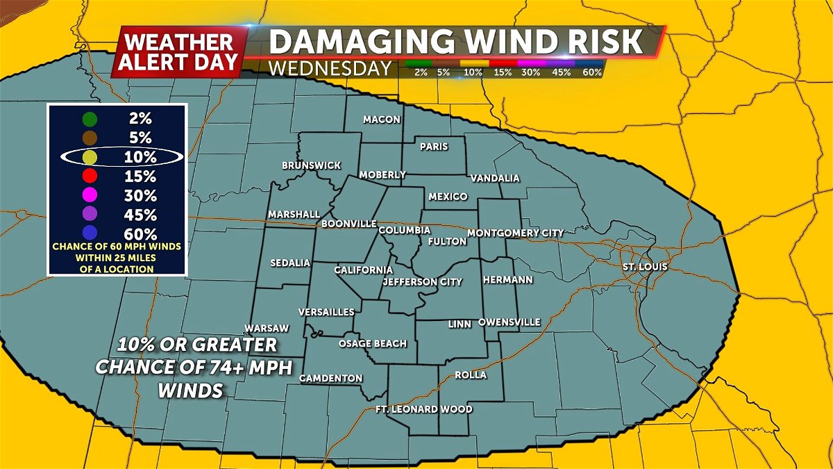
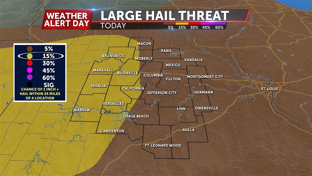
All types of severe weather will be possible with this line of storms. Hail, damaging wind, flash flooding, and tornadoes will all be possible, with damaging winds and hail being the most likely impacts.

TIMING
This is a frame work on timing. Given the highly variable nature of this event, you should expect things to change, and check the forecast often. Timing will have some impact on storm strength and forecast temperatures, but even an early morning arrival could carry a severe risk with it. There are a couple of scenarios that may play out; one being a morning arrival, and the other being an afternoon arrival. This will depend on when the storms develop, and its possible we see both coming in two separate rounds.
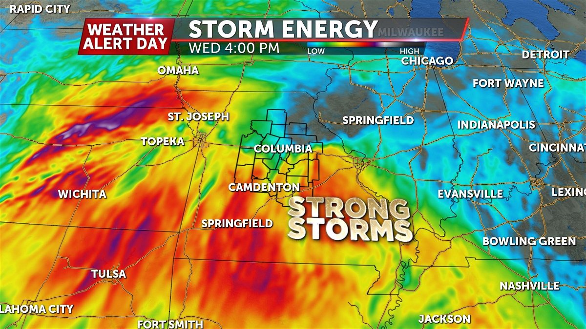
The atmosphere will have enough instability early Wednesday morning, that an arrival here could still present potential for severe, but an afternoon arrival may be that much stronger with additional instability from daytime surface heating. Current estimates bring the line of storms into mid-Missouri initially, as soon as 4:00 a.m. - 5:00 a.m. This is just the initial round of thunderstorms. Depending on how well instability or storm energy rebounds later into the afternoon, more redevelopment will be something to watch as could pose another severe threat.
More chances for storms linger in the days ahead, but confidence is low in timing and placement of these rain chances. What we do know is that an active pattern is in play, as the upper level jet stream will remain overhead through the weekend. As long as enough moisture and and instability remain in place, we can count on more chances for rain.
