Weather Alert Day: Heaviest snow sliding south this morning
THURSDAY AFTERNOON UPDATE:
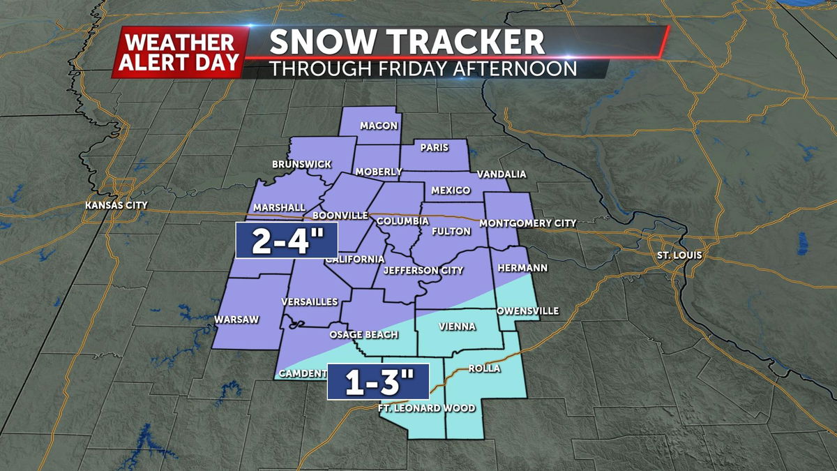
Snowfall amounts with this morning's last-minute data is coming in a little higher. The highest amounts will still be expected in our northwestern counties, but more of us look to end up closer to 2-4". Most of our accumulation will come with the wave expected tonight.
WEDNESDAY EVENING UPDATE:
As the storm system gets closer to us, there have been some changes to the forecast in the timing and snow totals have increased slightly across the board with two distinct waves of snow between Thursday and Friday. The first round moves in early Thursday morning for northwest Missouri, and continues for areas along and north of I-70 through Thursday afternoon. The second round looks to impact more of the southern half of Mid-Missouri, with snow showers continuing to slowly work south-southeast through early Friday afternoon.
BLOG:
The ABC 17 Stormtrack Weather Team has issued a Weather Alert Day effective from Thursday afternoon through noon on Friday for the potential of accumulating snow across most of Mid-Missouri.
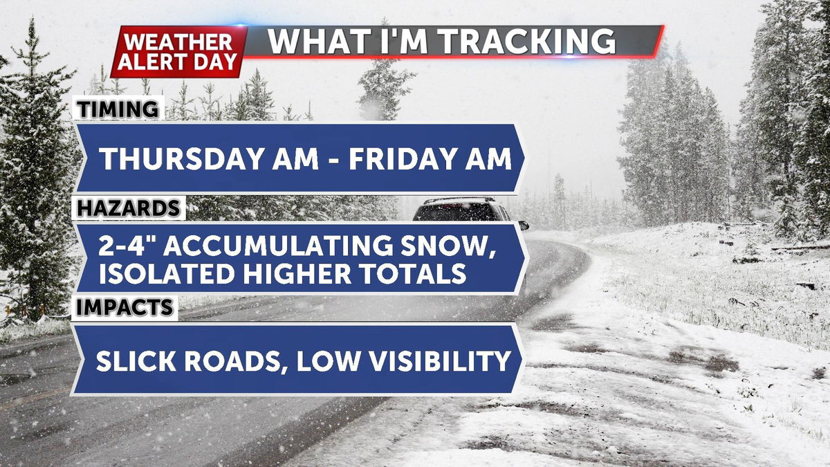
Road impacts are expected by Thursday afternoon and could continue into Friday as temperatures remain right around freezing for much of the day.
SETUP:
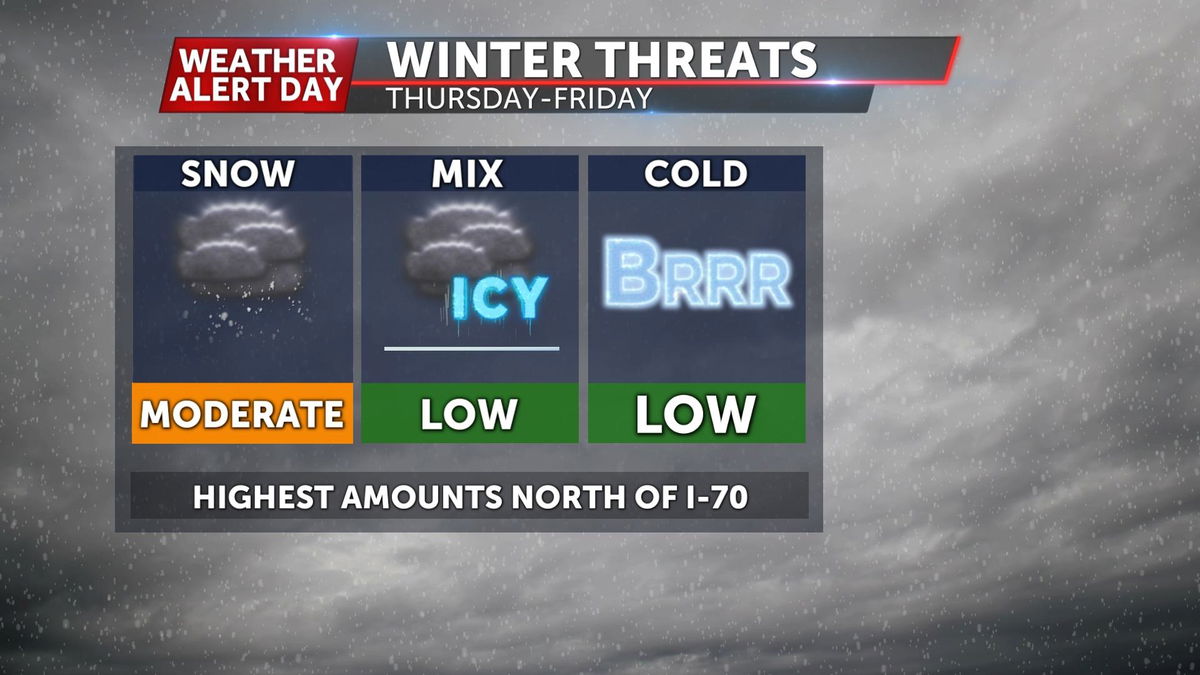
A deep area of low pressure is developing in the upper levels of the atmosphere, and that associated disturbance starts moving over the Rockies into the Plains on Wednesday. Meanwhile, a frontal boundary is expected to stall out over Mid-Missouri Wednesday night into Thursday, creating a dividing line between temperatures below and above freezing. As this disturbance gets closer, precipitation is expected to develop across northwest Missouri and eastern Kansas late Wednesday night into Thursday. Precipitation will spill south throughout the day on Thursday, and at times will be enhanced by stronger low-level winds Thursday night.

TIMING:
Precipitation could briefly start as rain as temperatures try to get above freezing on Thursday, but that scenario is more likely the farther south you go across Mid-Missouri, especially south of I-70. Snow showers will start for areas north of Highway 24 by Thursday morning, moving into the I-70 corridor by late morning or early afternoon. Precipitation continues to slowly work south throughout the day, and will continue on into Thursday night. Snow showers are expected to exit to our east on Friday morning, with lingering patchy flurries or freezing drizzle possible during the day depending on temperatures.

IMPACTS:
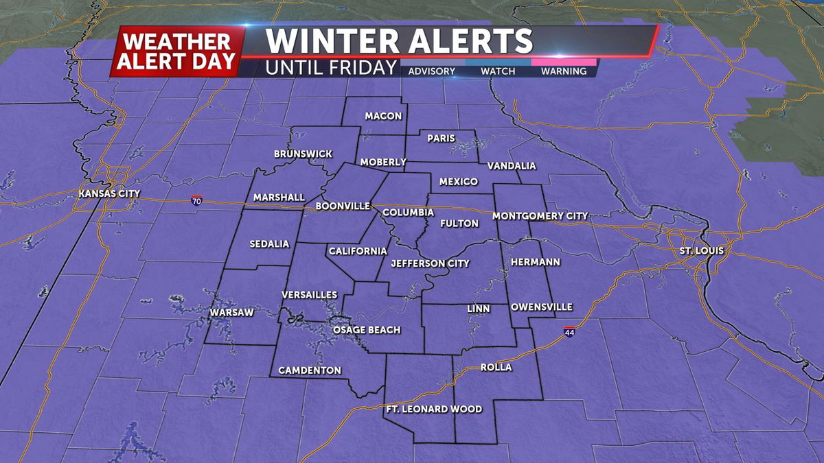
Most areas will be in the zone of 2-4" of snowfall accumulation, with slightly lower amounts near I-44. A Winter Weather Advisory is in effect until Friday for the entire Mid-Missouri viewing area. Slick roads will be a possibility but might be delayed as road temperatures have been warm after a week of spring-like temperatures. Count on slick spots on untreated routes Thursday night through Friday morning as air temperatures dip into the 20s. Wind chills will also be an issue on Friday night as snow moves out with feels like temperatures in the single digits.
PREPARE:
We're constantly updating this blog with the latest forecast model data, snow totals, and potential timing changes. Book mark this on your ABC 17 Stormtrack Weather app (you can download that here). Meteorologist Kevin Schneider will have the earliest look at any updates to the forecast from 5:00 to 7:00 and 9:00 a.m., Meteorologist John Ross at Noon, and Chief Meteorologist Jessica Hafner at 5:00, 6:00, 6:30, and 10:00 p.m. on KMIZ. You can also see her at 9:00 p.m. on KQFX. All of our newscasts are live-streamed to abc17news.com, and you can see live radar at abc17news.com/weather.
