WATCH: Forecast update as temperatures drop to dangerous levels
Temperatures were plummeting Friday afternoon as another winter storm hit the area and they’re expected to get lower.
Continue Reading Temperatures were plummeting Friday afternoon as another winter storm hit the area and they’re expected to get lower.
Continue Reading
TODAY: Temperatures plummet this afternoon down to the teens by sundown. This will be ushered in via winds that may gust as high as 30-40 mph. Roads will quickly become treacherous as slick spots develop. For details on snow, read our ABC 17 Stormtrack Weather Alert Day Blog. TONIGHT: Dangerous cold hits quick as temperatures fall
Continue Reading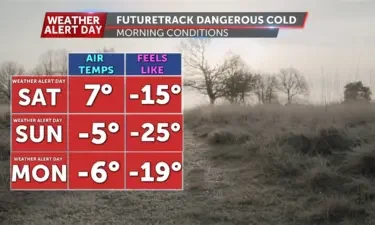
A live 10 a.m. forecast update.
Continue Reading
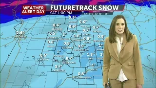
TODAY: We’re starting with widespread rain this morning, before switching to a wintry mix, and likely snow for most through the morning into the afternoon. Temperatures are near 40 at sunrise, but fall through the day, to put us near 20 this afternoon. Expect temperatures to fall another 20 degrees or so into the overnight
Continue Reading
MACON, Mo. (KMIZ) The Missouri Electric Cooperative is preparing for a second round of storms beginning Friday that are expected to bring powerful winds and snow. According to CEO of the Missouri Electric Cooperatives, Caleb Jones, storms that hit previously in the week on Tuesday left more than 20,000 people across four cooperatives without power
Continue Reading
This weekend looks to see dangerously low temperatures, but not just for yourself, for pets too. Professionals from the Horton Animal Hospital had important tips for pet owners to remeber this weekend. Some of these tips includes making sure to use pet safe salts, keeping your pet hydrated and make sure the water stays unfrozen,
Continue Reading
TONIGHT: Mostly cloudy with rain and a few thunderstorms late. Temperatures holding steady in the upper 30s. TOMORROW: Rain changes to snow from west to east by mid-late morning. Total snow accumulation around 1-2″. Strong winds will gust up to 45 mph as temperatures fall throughout the day into the low 20s. EXTENDED: We are
Continue Reading
Missouri agriculture is varied like our weather patterns, and it will also change with the warming climate. Shifting precipitation and temperatures will have sweeping effects on the environment and the food we can grow locally. Over recent decades Missouri has seen less extreme winter cold and hotter summers that change what plants can thrive in
Continue Reading
TODAY: Afternoon highs climb to nearly 40 degrees with winds out of the east at 8-12 mph. Skies remain mostly cloudy. TONIGHT: Overnight lows remain steady for much of Mid-Missouri into the upper 30s. Scattered showers move in after 6 pm for far northern portions of Central Missouri in Northern Macon. After 9 pm, the
Continue Reading
TODAY: Thursday is mostly cloudy and dry, with temperatures again approaching 40, but landing in the upper 30s for many. TONIGHT: Rain returns this evening, ahead of a quick moving low pressure system that will move in after the dinner hour. Rain begins as soon as 6-7 p.m. as spotty showers in the southwest, but
Continue Reading
A low pressure system looks to move into the region Friday causing the chance for portions of Mid-Missouri to see 1-3″ of snowfall, but on the back side of the snow we could see wind chills in the -10 to -20 degree range. With extreme cold setting in, hypothermia can set in within a short
Continue Reading
TONIGHT: Gradually decreasing clouds, lows in the upper 20s. TOMORROW: Partly to mostly cloudy with highs in the upper 30s. Rain moves in after sunset. EXTENDED: Another round of wintry weather is on the way for the end of the week, prompting another Weather Alert Day. A low pressure system will track northeast into the
Continue Reading
TODAY: Afternoon highs warm to near 40 degrees helping melt frozen slush on roadways with partly cloudy skies. Winds remain from the south at 8-12 mph and gusts up to 25 mph. TONIGHT: Overnight lows cool to the mid-20s as skies become mostly cloudy. Winds remain out of the south at 10-15 mph. EXTENDED: Thursday
Continue Reading
TODAY: Clouds will clear faster than the snow this morning. Expect slick conditions behind yesterday’s storms, as icy conditions remain this morning, after falling well below freezing overnight. Temperatures will climb from the teens, to near 40 this afternoon, with sunshine and southwest winds. Existing snow pack may keep most of us in the mid-to-upper
Continue Reading
Check back for updates related to weather conditions in Mid-Missouri.
Continue Reading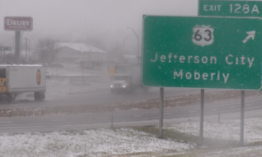
COLUMBIA, Mo. (KMIZ) During snow storms, it’s important to remember that the busier roads are going to be cleared first. Back roads and residential streets will take longer to get cleared. Chad Slate, with I-70 Towing, said there’s always more crashes and slide offs during the first big snow storm of the winter. “Any time
Continue Reading
TONIGHT: Snow exits early, but gusty winds up to 35 mph could blow snow over roads. Lows in the upper teens. Slick spots on untreated roads will be possible into the morning. TOMORROW: Gradual clearing with lighter winds. Highs in the upper 30s. EXTENDED: Snow showers continue to press east this afternoon as low pressure
Continue Reading
TUESDAY LATE AFTERNOON UPDATE: Snow showers are starting to exit the region from west to east, with snow ending east of Highway 63 between 6-7:00 p.m. While snow showers will come to an end, visibility could still be low as winds have gusted past 35 mph in some spots. Slick spots will be possible into
Continue Reading
TODAY: Snowfall continues to surge through Mid-Missouri with the heaviest bands becoming widespread from 2-5 pm. All falling snow looks to accumulate this afternoon and early evening thanks to at or below freezing surface temperatures. Travel impacts look to deteriorate with these heavier bands making for hazardous driving conditions. An additional 2-3″ is expected in
Continue Reading ABC 17 News went live at 4 a.m. Tuesday as snow continued to fall on Mid-Missouri during the first major snowstorm of the season.
Continue Reading